Method for selecting autonomous landing area of unmanned aerial vehicle under complex environment based on visual SLAM

A technology for complex environment and area selection, applied in attitude control, three-dimensional position/channel control and other directions, can solve problems such as poor practicability and achieve good practicability.

Inactive Publication Date: 2017-10-24
NORTHWESTERN POLYTECHNICAL UNIV +1
View PDF7 Cites 47 Cited by
  • Summary
  • Abstract
  • Description
  • Claims
  • Application Information

AI Technical Summary

Problems solved by technology

[0004] In order to overcome the shortcomings of poor practicability of the existing UAV landing area control methods, the present invention provides a method for selecting UAV autonomous landing areas in complex environments based on visual SLAM

Method used


Image

  • Method for selecting autonomous landing area of unmanned aerial vehicle under complex environment based on visual SLAM
  • Method for selecting autonomous landing area of unmanned aerial vehicle under complex environment based on visual SLAM
  • Method for selecting autonomous landing area of unmanned aerial vehicle under complex environment based on visual SLAM

Examples


Embodiment Construction

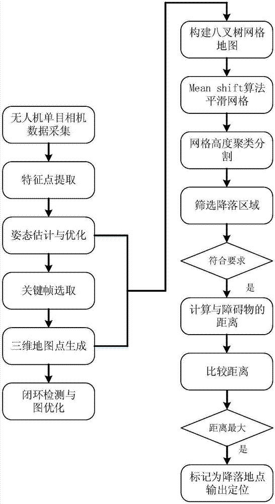
[0042] refer to figure 1 . The specific steps of the method for selecting the autonomous landing area of ​​the UAV in a complex environment based on visual SLAM in the present invention are as follows:

[0043] 1. Camera internal reference calibration.

[0044] Because the internal parameter matrix of the camera needs to be known in the process of pose calculation, the monocular camera onboard the drone is used to collect 20 images of the calibration board first, and Zhang’s calibration method is used to calibrate the internal parameters of the camera with the Matlab toolkit .

[0045] 2. Simultaneous positioning and mapping.

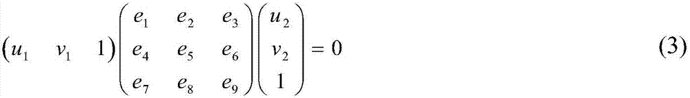
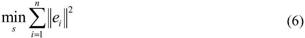
[0046] If the scene is a plane, or approximately a plane, or when the parallax is small, motion estimation can be performed through homography. However, using the basic matrix F to restore motion requires the scene to be a non-planar scene with large parallax. Although the camera is facing the ground, the data captured by the drone may have uneven ...


PUM


Abstract

The invention discloses a method for selecting an autonomous landing area of an unmanned aerial vehicle (UAV) under a complex environment based on visual SLAM, which is used for solving the technical problem of poor practicability of the existing UAV landing area control method. According to the technical solution, the method comprises the steps of obtaining an image sequence via an overlooking monocular camera carried by a UAV mobile platform, calculating the pose of the UAV in real time via an SLAM algorithm and establishing a sparse point cloud map, and meshing the point cloud map to construct a two-dimensional grid height map; then dividing the grid map according to the height in combination with a Means shift image segmentation algorithm, and finally screening an area that is farthest from a potential obstacle and is suitable for landing of the UVA according to the landing height requirement. According to the method, the pose of the UAV is calculated by adopting the monocular visual SLAM and estimated in real time, the two-dimensional grid height map is constructed, and the area suitable for landing of the UVA is screened. The method, which does not depend on a landmark, has good practicability.

Description

technical field [0001] The invention relates to a method for controlling a landing area of ​​an unmanned aerial vehicle, in particular to a method for selecting an autonomous landing area of ​​an unmanned aerial vehicle in a complex environment based on visual SLAM. Background technique [0002] As drones are used more and more widely, the safety of drones during flight is becoming more and more important. During the flight of the UAV, there are many situations that require emergency landing, such as low battery power, machine failure or some unexpected situations that require emergency landing in an unknown environment, so the autonomous landing of the UAV is of great significance. When the UAV selects a landing area, it needs to choose a flat landing area while avoiding obstacles. If the landing area cannot be screened well, it will lead to the failure of the drone to land, causing serious consequences such as machine damage. [0003] Document "Vison-based UAV Landing on...

Claims


Application Information

Patent Timeline
Patent Type & Authority Applications(China)
IPC IPC(8): G05D1/08G05D1/10
Inventor 杨涛李珮琦张慧明张艳宁
Owner NORTHWESTERN POLYTECHNICAL UNIV
Why Eureka
Try Eureka