Method for visualizing three-dimensional environmental map in virtual reality system

An environment map and virtual reality technology, applied in the field of virtual reality, can solve the problems of difficult parameter selection, large amount of live video image data, video streaming delay, etc., to reduce network communication bandwidth requirements, reduce communication bandwidth requirements, and compress The effect of the amount of map data

Active Publication Date: 2017-10-24
NAT UNIV OF DEFENSE TECH
View PDF5 Cites 16 Cited by
  • Summary
  • Abstract
  • Description
  • Claims
  • Application Information

AI Technical Summary

Problems solved by technology

Directly use the display device to display the robot environment video, the operator does not have a strong sense of presence in the third perspective, and usually the network bandwidth of the environment where the robot is located is limited, and the environment video is directly transmitted to the display device through the network, the amount of data is large and the required network The transmission bandwidth is large, and there are often delays and packet loss in the returned video stream, which not only increases the difficulty of the operator's operation, but also easily fatigues the operator;
[0005] 2) Directly use graphics functions to draw, that is, use graphics functions to directly draw real-scene images. The complexity of real scenes is generally relatively high, which includes a large number of irregular surfaces. It is difficult to select parameters for function drawing, and it is difficult to draw accurately. real-world images;
[0006] 3) Use third-party modeling software to model the environment and display the model after exporting, but this method must be based on environmental information. The modeling process is complicated to implement, and the application environment is limited, so it can only be applied to known scenarios. In the application of the unknown environment, it cannot be applied;
This type of method usually needs to be realized by relying on specific equipment and processing methods. The implementation process is complex and the implementation cost is high, and the amount of transmitted data is usually still large, which cannot meet the needs of applications with strict communication bandwidth requirements.
[0008] Chinese patent application CN106131493A discloses a somatosensory control system based on a virtual reality remote on-site intelligent fire-fighting robot, in which the head-mounted reality module receives live video images collected by the robot for 3D visual display, so that the operator can obtain the live robot Live video images, but to directly obtain live video images for 3D visual display, on the one hand, complex visual algorithms are required to realize image 3D video display; Wider network communication bandwidth

Method used


Image

  • Method for visualizing three-dimensional environmental map in virtual reality system
  • Method for visualizing three-dimensional environmental map in virtual reality system
  • Method for visualizing three-dimensional environmental map in virtual reality system

Examples


Embodiment Construction

[0032] The present invention will be further described below in conjunction with the accompanying drawings and specific preferred embodiments, but the protection scope of the present invention is not limited thereby.

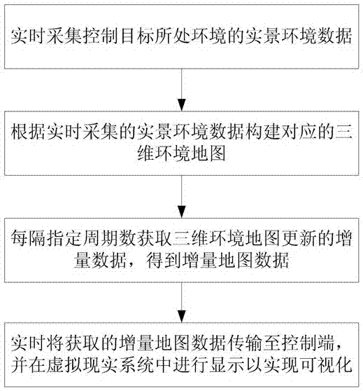
[0033] Such as figure 1 , 2 As shown, the steps of the visualization method of the three-dimensional environment map in the virtual reality system of this embodiment are as follows:

[0034] S1. Real-time collection of real-time environmental data of the environment where the control target is located.

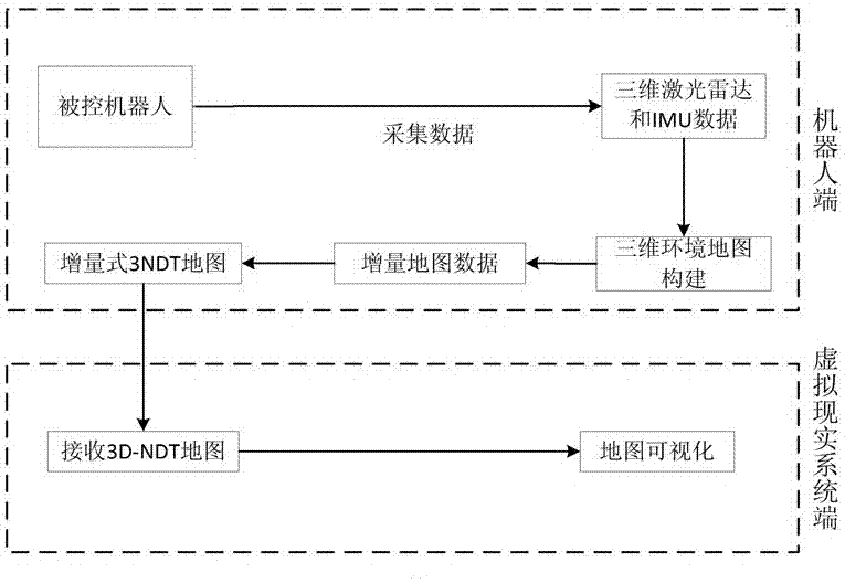
[0035] The control target is the remote-controlled robot, which can be an aircraft, land mobile robot or underwater robot, etc. By arranging collection equipment on the robot side, the real-time environmental data of the scene where the robot is located is collected in real time.

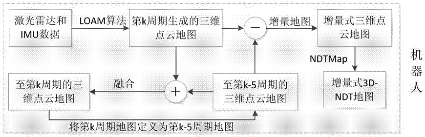
[0036] In a specific application example, the real-scene environmental data of the environment where the control target is located is collected through the lidar and IMU (inertial m...


PUM


Abstract

The invention discloses a method for visualizing a three-dimensional environmental map in a virtual reality system. The method includes: S1, acquiring and controlling real environment data of an environment where a target locates; S2, constructing a corresponding three-dimensional environmental map according to the real environment data acquired in real time; S3, acquiring updating incremental data of the three-dimensional environmental map at specified period intervals to obtain increment map data; S4, transmitting the increment map data acquired in real time to a control end, and displaying in the virtual reality system to realize visualization of the three-dimensional environmental map. The method is capable of realizing visualization of the three-dimensional environmental map in the virtual reality system and has the advantages of simplicity in realizing method, low realizing cost, small needed communication bandwidth, flexibility in application environments, good realizing effect and the like.

Description

technical field [0001] The invention relates to the technical field of virtual reality, in particular to a visualization method for a three-dimensional environment map in a virtual reality system. Background technique [0002] Virtual Reality (VR) technology is widely used in various fields such as rescue and high-risk operations, that is, the operator performs various operations on the remote control robot, and the operator only needs to control the robot according to the real-time environment in which the robot is located. , without the need for operators to operate on-site, with high execution efficiency and safety performance. During the remote control process, the operator needs to obtain the robot environment information in real time through network data transmission because he cannot directly obtain the robot environment information, so as to control the robot to perform corresponding actions. [0003] In order to realize the visualization of robot environment inform...

Claims


Application Information

Patent Timeline
Patent Type & Authority Applications(China)
IPC IPC(8): G06F17/30G06T17/00G06T19/00
CPCG06F16/904G06T17/00G06T19/003
Inventor 肖军浩王盼张辉卢惠民李义陈谢沅澧
Owner NAT UNIV OF DEFENSE TECH
Why Eureka
Try Eureka