Supercharge Your Innovation With Domain-Expert AI Agents!

Method for converting unmanned aerial vehicle operation data into air traffic control monitoring information format

A technology of operating data and information format, applied in radio transmission systems, electrical components, transmission systems, etc., can solve problems such as unmanned aerial vehicles cannot receive and process operating data, and are not equipped with secondary surveillance radar, etc., to make up for low-altitude surveillance blind spots , Improve economic and social benefits, and save resources

Inactive Publication Date: 2017-11-03
青岛云世纪信息科技有限公司
View PDF3 Cites 9 Cited by
  • Summary
  • Abstract
  • Description
  • Claims
  • Application Information

AI Technical Summary

Problems solved by technology

[0004] However, drones that mainly fly at low and ultra-low altitudes are generally not equipped with secondary surveillance radar (SSR) transponders or ADS-B airborne equipment, and mainly use satellite navigation systems such as global satellite navigation (GPS) or Beidou (BD2) For positioning, the UAV operation data obtained by the UAV cloud system cannot be directly received and processed by the existing ATC system, and must be equipped with a dedicated independent UAV monitoring system
Therefore, such "low altitude, small and slow" targets have become the monitoring "blind spot" of the existing domestic ATC system, which is a major hidden danger in the current air safety. In order to strengthen monitoring and ensure air order, the ATC system must be solved technically. The problem of accessing drone operation data

Method used


Image

  • Method for converting unmanned aerial vehicle operation data into air traffic control monitoring information format
  • Method for converting unmanned aerial vehicle operation data into air traffic control monitoring information format
  • Method for converting unmanned aerial vehicle operation data into air traffic control monitoring information format

Examples


Embodiment Construction

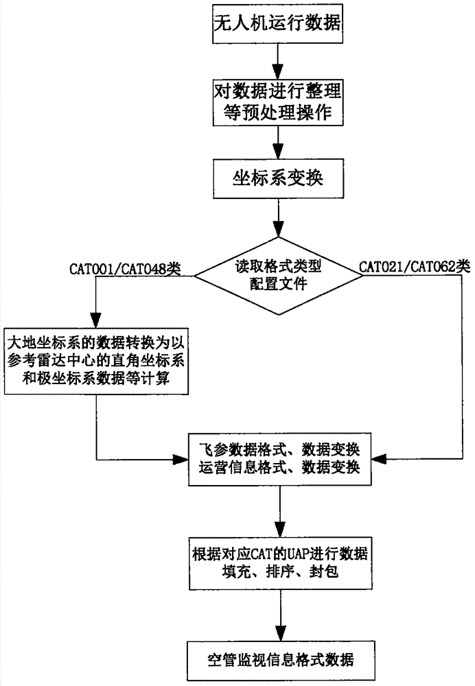
[0033] See attached picture. Such as figure 1 , figure 2 and image 3 As shown, the present invention discloses a method for converting unmanned aerial vehicle operation data into an air traffic control monitoring information format, and the method includes the following steps:

[0034] Step (1), read the drone operation data;

[0035] Step (2), performing preprocessing operations such as coding and data sorting on the data;

[0036] Step (3), the received non-WGS-84 geodetic coordinate system (such as CGCS-2000 coordinate system, Beijing 54, Xi'an 80 coordinate system) UAV flight parameter data (mainly including longitude and latitude position, altitude, relative ground Height, speed and acceleration in the geodetic coordinate system, etc.) are transformed into data based on the WGS-84 coordinate system.

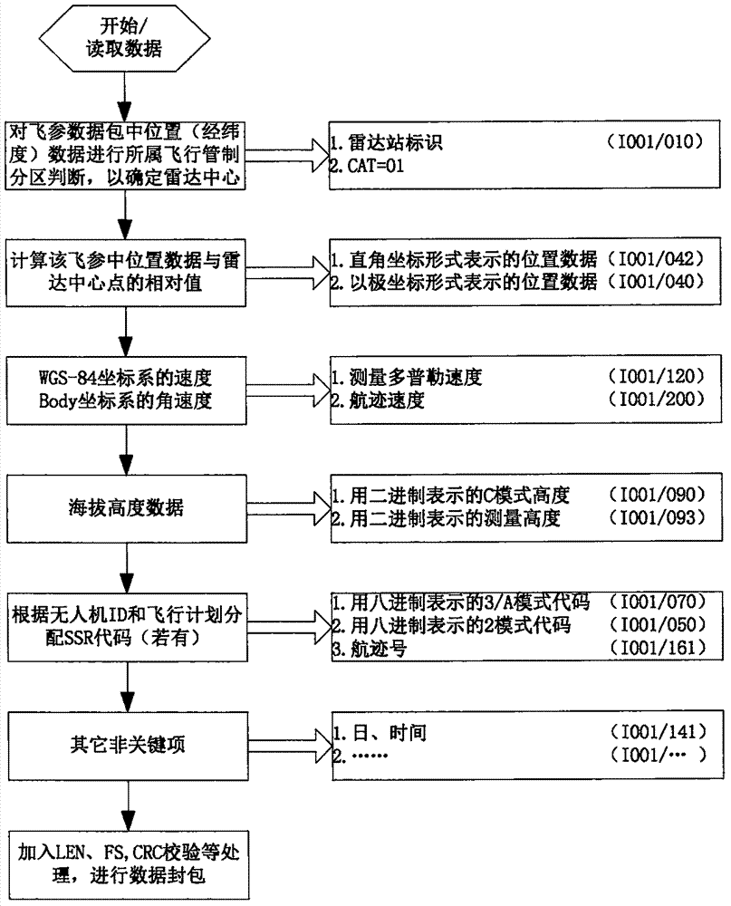
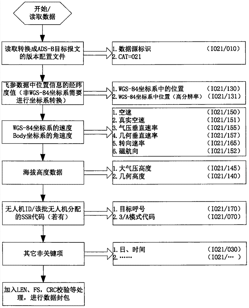
[0037] Step (4), when it needs to be converted into CAT001 single radar target report data in the European standard Asterix, such as figure 2 As shown in the flowch...


PUM


Abstract

The invention discloses a method for converting unmanned aerial vehicle operation data into an air traffic control monitoring information format and belongs to the field of computer technology application to monitor data processing and transmission in an unmanned aerial vehicle cloud system and an air traffic control automatic system. The method is mainly used for solving the problem that an existing air traffic control automatic system cannot directly receive and process the unmanned aerial vehicle operation data output by the unmanned aerial vehicle cloud system. The main thinking of the method comprises the steps of carrying out operations such as sorting and coordinate system conversion and data sorting and filling on the received unmanned aerial vehicle operation data; and converting the unmanned aerial vehicle operation data into data of single radar target message or ADS-B target message and monitoring data processing system track message transmission and exchange data formats in European standard Asterix. After the data is converted, the data can be directly transmitted to the ATC system. The data can be directly processed by the existing ATC system without upgrading or modification. A low altitude monitoring dead zone in the current ATC system is compensated. The method has very high economic benefit and social effect. The method can be widely applied to the ATC system and the unmanned aerial vehicle cloud system and has wide application prospect.

Description

technical field [0001] This method is a kind of data processing and data conversion of UAV operation data (including data such as operation information, position, height and speed) into single radar target report in European standard Asterix format or ADS-B target report and other air traffic control monitoring information formats. transfer method. It belongs to the computer technology application field of receiving, processing and transmitting the operation data of the UAV in the UAV cloud system or the air traffic control automation system. Background technique [0002] An unmanned aerial vehicle (UAV), also known as an unmanned aerial vehicle, is an aircraft that flies autonomously or is managed remotely by a control station. UAV operation data mainly includes data such as operation information, location, height and speed, among which operation information mainly includes UAV ID, UAV operator information (affiliation company, etc.) Human-machines are generally positione...

Claims


Application Information

Patent Timeline
IPC IPC(8): H04L29/08H04B7/185
CPCH04B7/18506H04L67/565
Inventor 刘向东
Owner 青岛云世纪信息科技有限公司
Features
  • R&D
  • Intellectual Property
  • Life Sciences
  • Materials
  • Tech Scout
  • Unparalleled Data Quality
  • Higher Quality Content
  • 60% Fewer Hallucinations
Learn More