Remote-sensing image feature selection method based on early land thematic map

A feature selection method and remote sensing image technology, applied in the field of object-oriented remote sensing image analysis, can solve the problems of unsupervised, few feature selection methods, limited improvement of image analysis effect, etc., and achieve the effect of improving effect and accuracy

Active Publication Date: 2017-11-24
HOHAI UNIV
View PDF6 Cites 3 Cited by
  • Summary
  • Abstract
  • Description
  • Claims
  • Application Information

AI Technical Summary

Problems solved by technology

[0004] Although scholars have proposed a large number of feature selection methods and carried out numerous feature selection experiments; most of the methods and experiments are unsupervised (without the support of prior knowledge), globally consistent (oriented to the optimal Feature selection is difficult to do adaptive optimization for the local characteristics of the image), so the improvement of image analysis effect is limited
[0005] To sum up, in the currently visible patent and literature research, most feature selection methods are unsupervised and globally fixed, while there are few feature selection methods that can effectively incorporate prior knowledge and can be locally adaptively optimized. In particular, there are still many problems in the integration mechanism of prior knowledge, the adaptive optimization method and process of feature weights, and the application of feature weights in remote sensing analysis, and no practical solutions have been developed.

Method used


Image

  • Remote-sensing image feature selection method based on early land thematic map
  • Remote-sensing image feature selection method based on early land thematic map
  • Remote-sensing image feature selection method based on early land thematic map

Examples


Embodiment Construction

[0030] The present invention will be further described below in conjunction with the accompanying drawings. The following examples are only used to illustrate the technical solution of the present invention more clearly, but not to limit the protection scope of the present invention.

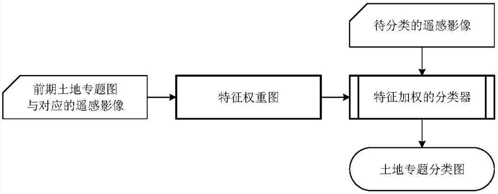
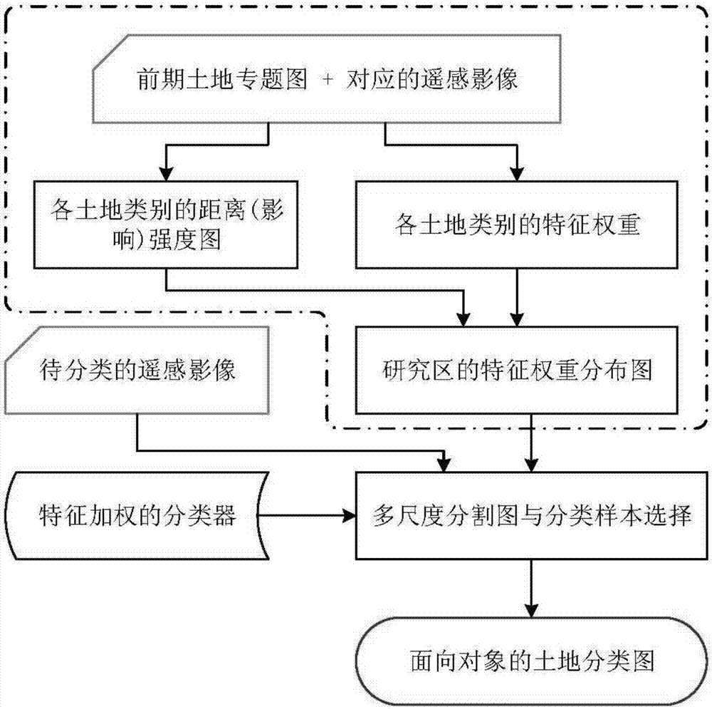
[0031] figure 1 is a schematic diagram of remote sensing image feature selection supported by the previous land thematic map. In the step of calculating the feature weight map, the distance intensity map of each land category and the feature weight of each land category are extracted from the previous land thematic map and its corresponding remote sensing image. Matrix, and construct the feature weight map of the experimental area; in the feature weighted classification step, according to the spatial position of the object to be analyzed in the segmentation map, the weight of each feature is queried from the feature weight map, and the weight of the classifier is set accordingly ; In this way, ...


PUM


Abstract

The invention discloses a remote-sensing image feature selection method based on an early land thematic map; the method comprises the steps of selecting a remote-sensing image partitioning algorithm and an image feature set of partitioning objects, and setting corresponding partitioning parameters and a feature extraction algorithm; segmenting the early land thematic map into a corresponding amount of layers according to plot classes, and extracting an influence strength map and a feature weight matrix to generate a feature weight distribution map; partitioning a remote-sensing image to be analyzed, and extracting image features of the partitioning objects; selecting an image classifier, modifying weight settings of classification features of the image classifier, and constructing a feature weighted classifier; setting feature weights for the objects in the partitioned maps, inputting image features and weights of the objects into the feature weighted classifier, and calculating land classes of the partitioning objects to generate a land thematic map. The method of the invention has the advantages that feature weights of local areas of a remote-sensing image can be adaptively optimized and adjusted, and remote-sensing image analysis precision can be improved.

Description

technical field [0001] The invention relates to a remote sensing image feature selection method based on a previous land thematic map, and belongs to the field of object-oriented remote sensing image analysis. Background technique [0002] With the rapid development of high (spatial) resolution remote sensing, object-based remote sensing analysis (Object-Based Image Analysis, OBIA) method has become the main technical means of remote sensing applications. Compared with the traditional pixel-based remote sensing analysis technology, the object-oriented image analysis method can fully exploit the rich geometric features, texture features and spatial pattern features of high-resolution images on the basis of using the spectral characteristics of the image. etc., and can further integrate high-level knowledge such as socio-economic and spatial models to achieve higher-precision and more efficient image analysis. Corresponding references on object-oriented remote sensing analysi...

Claims


Application Information

Patent Timeline
Patent Type & Authority Applications(China)
IPC IPC(8): G06T7/11G06T7/194G06T7/33G06K9/62
CPCG06T7/11G06T7/194G06T7/33G06T2207/10032G06T2207/20021G06T2207/20152G06T2207/20112G06F18/24147
Inventor 周亚男
Owner HOHAI UNIV
Why Eureka
Try Eureka