High precision water level elevation extraction algorithm

A high-precision, high-level technology, applied in the field of satellite remote sensing and geographic information, can solve the problem that the interference echo waveform of the Cryosat-2 satellite cannot be solved well, and achieve the effect of precise extraction

Active Publication Date: 2017-12-01
青岛美吉海洋地理信息技术有限公司
View PDF3 Cites 24 Cited by
  • Summary
  • Abstract
  • Description
  • Claims
  • Application Information

AI Technical Summary

Problems solved by technology

[0006] Many existing re-tracking algorithms (such as: ocean, Ice-1, Ice-2, sea-ice and OceanCS, etc.) are almost all proposed for the uncontaminated ...

Method used


Image

  • High precision water level elevation extraction algorithm
  • High precision water level elevation extraction algorithm
  • High precision water level elevation extraction algorithm

Examples


Embodiment

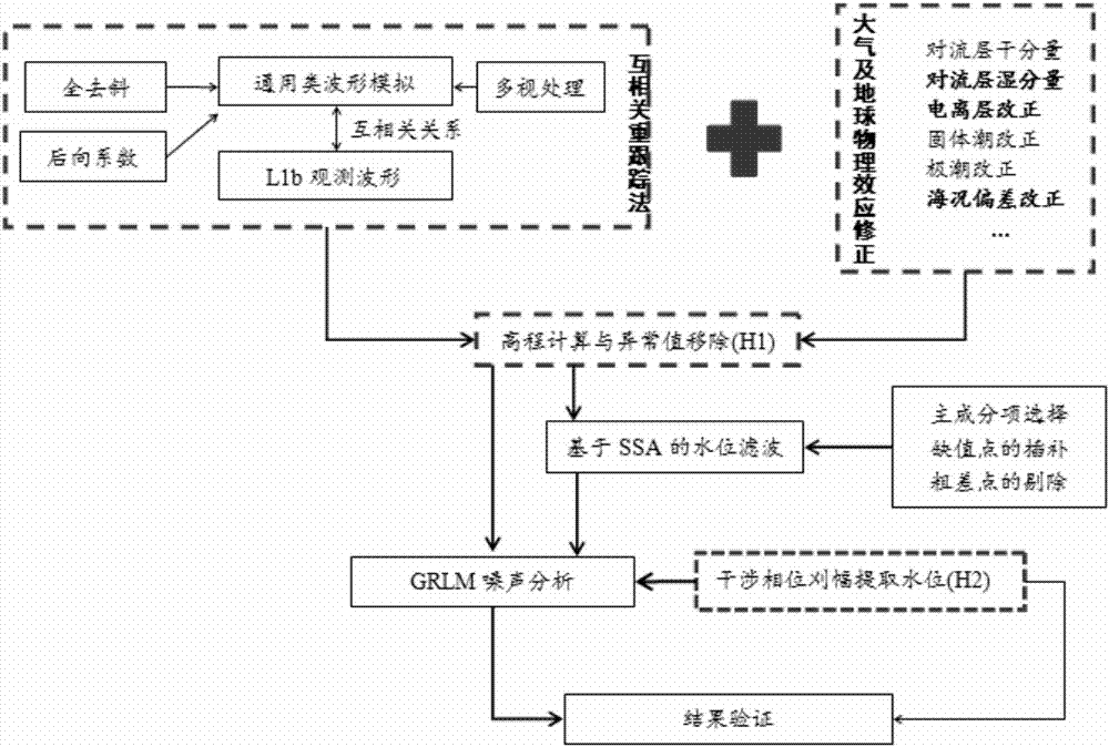
[0043] The specific technical solution process of this embodiment is as follows: figure 1 As shown, it mainly includes the following five steps:

[0044] (1) Simulation of general-purpose waveforms;

[0045] (2) Cross-correlation re-tracking algorithm between general-purpose waveforms and Level 1b interference waveforms;

[0046] (3) Correction of atmospheric and geophysical effects;

[0047] (4) Elevation calculation and outlier exclusion;

[0048] (5) Water level filtering and noise analysis based on SSA.

[0049] The following is a detailed analysis of the above process:

[0050] (1) Simulation of general-purpose waveforms

[0051] Through the research on the interference processing process of the cryosat-2 satellite and sub-satellite echo signals, we mainly solve the signal modulation problems in the following three aspects in the process of simulating general-purpose waveforms: Simulation, simulation of waveform from deramped echoes, setting of optimal waveform back...


PUM


Abstract

The invention discloses a high precision water level elevation extraction algorithm comprising simulation of a universal waveform; mutual correlation retracing algorithm of the universal waveform and a Level 1b interference waveform; atmosphere and geophysical correction; elevation computation and exclusion of abnormal values; and water level filtering and noise analysis based on SSA. Due to limitation of a satellite altimeter and complex geographical environment, a Cryosat-2 Level 2 altimeter data product has a lot of data losses and precision losses in an inland or nearshore region, the invention improves an altimeter echo waveform retracing algorithm to extract a high precision wave level sequence product, and thus the defect that inland water body or nearshore height measurement data is small in quantity and not high in precision is remedied.

Description

technical field [0001] The invention belongs to the technical field of satellite remote sensing and geographic information, and in particular relates to a water surface elevation extraction method based on satellite altimetry. Background technique [0002] Satellite altimetry is used as an effective tool to extract water level (water surface elevation) with ranging accuracy ranging from decimeter to centimeter level. The water level is usually calculated by fitting the theoretical echo model of the satellite altimeter with the received waveform. This process is called Waveform retracking. The secondary GDR data of the satellite altimeter has undergone waveform re-tracking processing before the release, and the possible data elimination of the waveform that is greatly affected by the land terrain has been carried out. The number of lakes observed by satellite altimeter data is very limited. Since the diameter of the ground footprint illuminated by radar altimeter (T / P, Jaso...

Claims


Application Information

Patent Timeline
IPC IPC(8): G01C5/00G01F23/284G01S19/14
CPCG01C5/00G01F23/284G01S19/14
Inventor 高乐郭伟王邦松
Owner 青岛美吉海洋地理信息技术有限公司
Why Eureka
Try Eureka