Landsat8 remote sensing ground surface temperature inversion method

A technology for surface temperature and remote sensing inversion, applied in radiation pyrometry, measurement devices, instruments, etc., can solve the problems of complex logic structure and low inversion accuracy, and achieve low acquisition cost, high signal-to-noise ratio, and current situation. Good results

Inactive Publication Date: 2018-01-09
TAIYUAN UNIV OF TECH
View PDF4 Cites 11 Cited by
  • Summary
  • Abstract
  • Description
  • Claims
  • Application Information

AI Technical Summary

Problems solved by technology

[0022] The object of the present invention is to provide a kind of practical Landsat8 remote sensing inversion surface temperature method, aims to solve the problem that the inversion precision of existing similar algorithm technology is slightly low and logic structure is complicated

Method used


Image

  • Landsat8 remote sensing ground surface temperature inversion method
  • Landsat8 remote sensing ground surface temperature inversion method
  • Landsat8 remote sensing ground surface temperature inversion method

Examples


Embodiment Construction

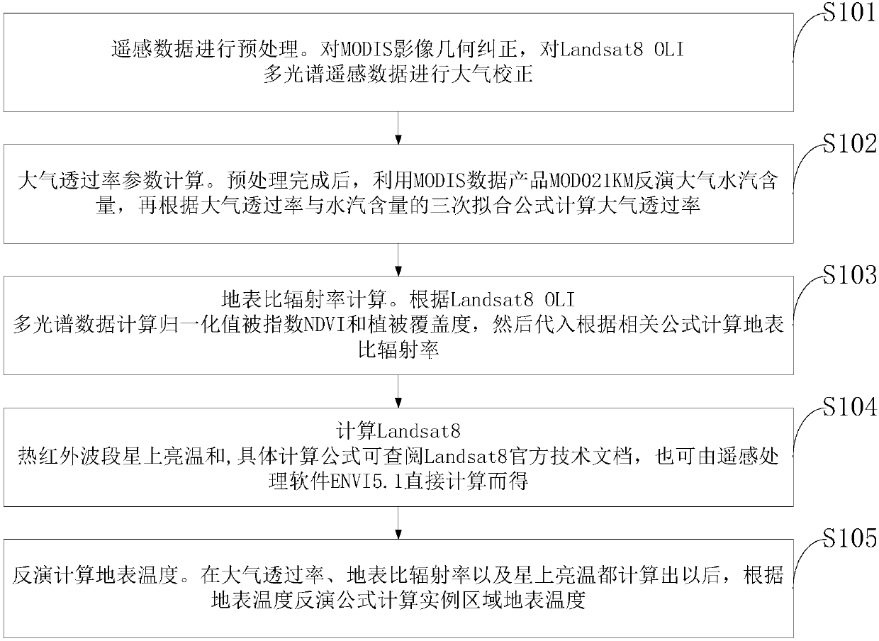
[0052] In order to make the object, technical solution and advantages of the present invention clearer, the present invention will be further described in detail below in conjunction with the examples. It should be understood that the specific embodiments described here are only used to explain the present invention, not to limit the present invention.

[0053] Taking the urban area of ​​Taiyuan City as the example area, the Landsat8OLI multi-spectral and TIR thermal infrared remote sensing data and the MODIS data corresponding to the same day and similar phases in the summer of June 27, 2013 under the cloudless and sunny weather covering the example area were selected as the surface temperature reflection. Perform data source. The remote sensing data projection is Universal Transverse Mercator (UTM) North 49 area, and the projection datum is WGS-84 ellipsoid.

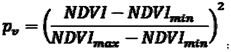
[0054] Such as figure 1 As shown, the Landsat8 remote sensing retrieval surface temperature method provided by the...


PUM


Abstract

The present invention discloses a Landsat8 remote sensing ground surface temperature inversion method. The method includes the following steps that: step 1, atmospheric water vapor content w is calculated; step 2, an atmospheric transmissivity tau10 and an atmospheric transmissivity tau11 which are corresponding to two thermal infrared bands of the Landsat8 are calculated; step 3, a ground surfaceemissivity epsilon10 and a ground surface emissivity epsilon11 corresponding to the two thermal infrared bands of the Landsat8 are calculated; and step 3, ground surface temperature TS is calculatedthrough inversion: on the basis of the step 1 to step 3, the above parameter calculation results are substituted into an inversion formula to calculate a surface temperature value. According to the Landsat8 remote sensing ground surface temperature inversion method of the invention, Landsat8 remote sensing ground surface temperature inversion algorithm technology is improved and developed throughdifferent algorithm ideas, so that the accuracy of the calculation of the ground surface temperature by means of inversion through the thermal infrared bands of the Landsat8 can be improved; non-professionals can better understand and master the algorithm technology by means of simple and direct logical relationships, and therefore, the algorithm technology can be widely used and can fruit certainoverall efficiency and overall value.

Description

technical field [0001] The invention belongs to the field of remote sensing and earth observation, in particular to a Landsat8 remote sensing inversion method for surface temperature. Background technique [0002] With the development of remote sensing and earth observation technology, the extraction and monitoring of the surface temperature can be realized by carrying the thermal infrared band on the satellite. Since the 1990s, after many studies, the algorithms of remote sensing inversion of land surface temperature have been extensively studied. Up to now, they have roughly formed three types: single-channel, dual-channel and multi-angle inversion algorithms. Qin et al. (2001) proposed a single-window inversion algorithm for land surface temperature suitable for Landsat TM thermal infrared remote sensing data. Subsequently, Jiménez- &Sobrino (2003) and Jiménez- (2009) proposed a general single-channel temperature inversion algorithm. Scholars such as Li et al. (2004)...

Claims


Application Information

Patent Timeline
Patent Type & Authority Applications(China)
IPC IPC(8): G01J5/00
Inventor 晋美俊李俊明胡允涛
Owner TAIYUAN UNIV OF TECH
Why Eureka
Try Eureka