High-spatial-and-temporal-resolution land surface temperature fusion method based on multi-source satellite data

A technology with spatial and temporal resolution and satellite data, which is applied in the field of satellite remote sensing and can solve problems such as inability to obtain

Active Publication Date: 2018-01-19
北京航天绘景科技有限公司
View PDF3 Cites 9 Cited by
  • Summary
  • Abstract
  • Description
  • Claims
  • Application Information

AI Technical Summary

Problems solved by technology

However, it is currently based on the fusion of two sensors, mostly focusing on MODIS and TM; when more sat

Method used


Image

  • High-spatial-and-temporal-resolution land surface temperature fusion method based on multi-source satellite data
  • High-spatial-and-temporal-resolution land surface temperature fusion method based on multi-source satellite data
  • High-spatial-and-temporal-resolution land surface temperature fusion method based on multi-source satellite data

Examples


Embodiment Construction

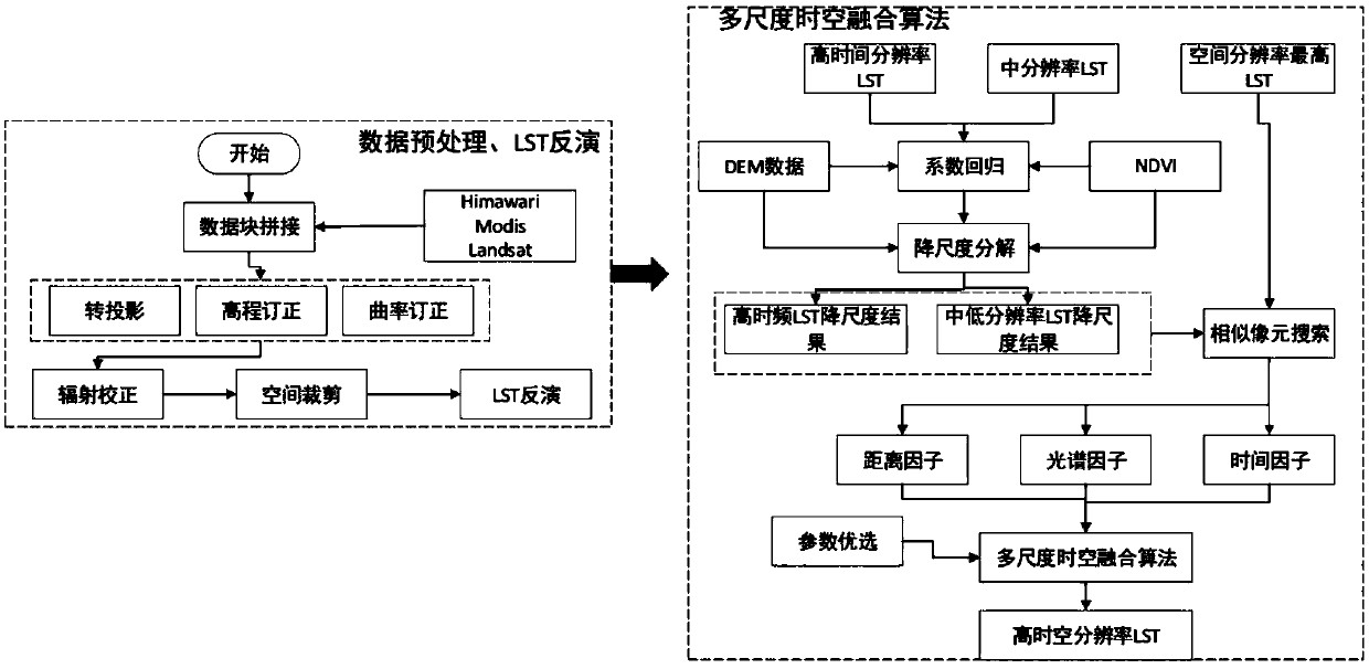
[0042] The present invention will be described in further detail below in conjunction with the accompanying drawings and examples. The following examples are only descriptive, not restrictive, and cannot limit the protection scope of the present invention.

[0043] To make the purposes, technical solutions and advantages of the embodiments of the present invention clearer, the technical solutions in the embodiments of the present invention will be clearly and completely described below with reference to the accompanying drawings in the embodiments of the present invention. Obviously, the described embodiments are Some, but not all, embodiments of the present invention. The components of the embodiments of the invention generally described and illustrated in the drawings herein may be arranged and designed in a variety of different configurations. Thus, the following detailed description of the embodiments of the invention provided in the accompanying drawings is not intended t...


PUM


Abstract

The invention discloses a high-spatial-and-temporal-resolution land surface temperature fusion method based on multi-source satellite data, which is characterized by including the following steps: A,inputting multiple pieces of satellite image data, and preprocessing the satellite image data; B, selecting the preprocessed satellite image data for land surface temperature (LST) inversion; and C, carrying out fusion calculation on the result of LST inversion to get LST data with high spatial and temporal resolution. According to the invention, fusion calculation can be carried out on the imagedata of multiple satellite sensors to get more accurate land surface temperature with high spatial and temporal resolution.

Description

technical field [0001] The invention belongs to the field of satellite remote sensing, and in particular relates to a land surface temperature fusion method with high temporal and spatial resolution based on multi-source satellite data. Background technique [0002] Land Surface Temperature (LST) is a key parameter of land surface system processes on regional and global scales. It integrates the interaction between the surface and the atmosphere and the results of the energy exchange between the atmosphere and the land, and is widely used in surface energy. Research fields such as balance, climate change and resource and environmental monitoring. Timely grasping the temporal and spatial distribution of land surface temperature on the regional and global scales, especially the comprehensive, complete and continuous temporal and spatial distribution of land surface temperature, is of great significance for the study of the energy balance of the earth-atmosphere system and the ...

Claims


Application Information

Patent Timeline
IPC IPC(8): G06T3/40G06T5/50G06T5/00G01N21/31G01N21/35G01J5/00
Inventor 屈新原杨鹤松盖滢
Owner 北京航天绘景科技有限公司
Why Eureka
Try Eureka