Three-dimensional automatic modeling and visualization method for city building

An automatic modeling and building technology, applied in 3D modeling, image data processing, special data processing applications, etc., can solve the problems of lack of catastrophe scenario simulation technology, improve modeling processing efficiency, fast visual expression, The effect of fast data reading and rendering

Inactive Publication Date: 2018-01-19
EARTHQUAKE ADMINISTRATION OF BEIJING MUNICIPALITY
View PDF4 Cites 16 Cited by
  • Summary
  • Abstract
  • Description
  • Claims
  • Application Information

AI Technical Summary

Problems solved by technology

Therefore, in the current earthquake prevention and disaster reduction work, there is a lack of catastrophe scenario simula

Method used


Image

  • Three-dimensional automatic modeling and visualization method for city building
  • Three-dimensional automatic modeling and visualization method for city building
  • Three-dimensional automatic modeling and visualization method for city building

Examples


Embodiment Construction

[0023] In order to make the above objects, features and advantages of the present invention more obvious and understandable, the present invention will be further described below through specific embodiments and accompanying drawings.

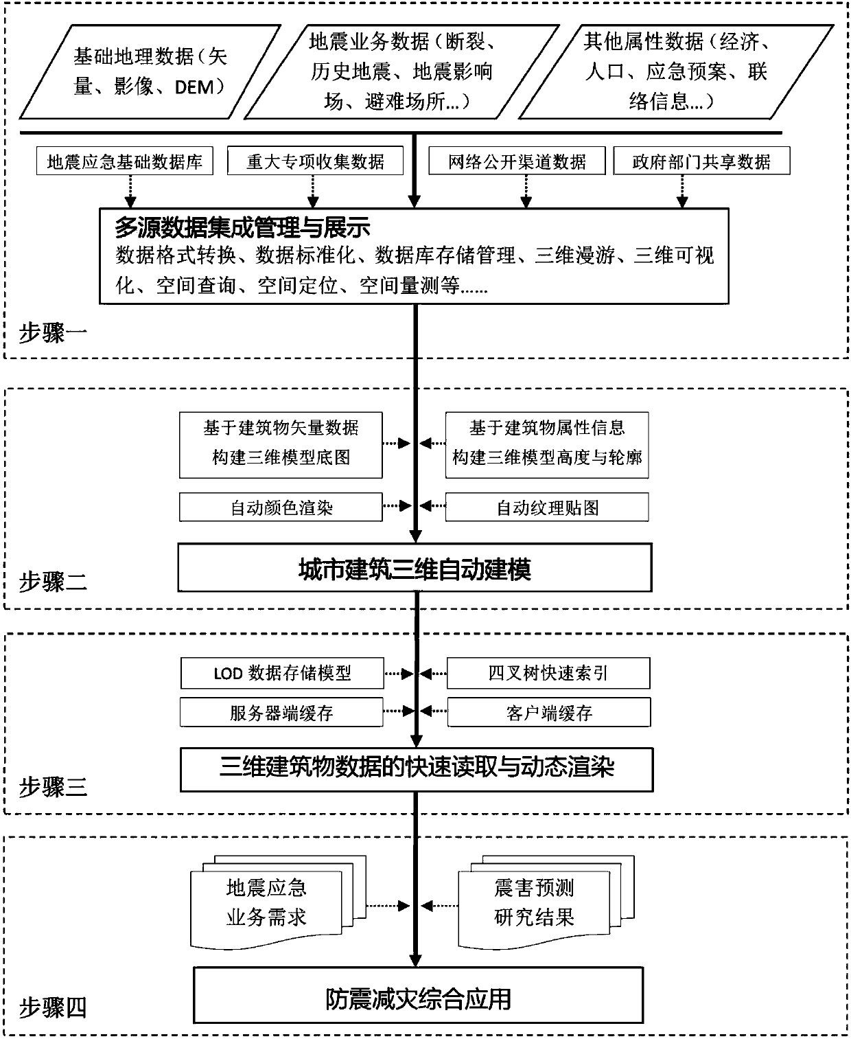
[0024] As technical process of the present invention figure 1 As shown, it is mainly divided into the following steps:

[0025] 1) Step 1: Multi-source data integration management and display

[0026] In the data preprocessing stage, multi-source data is integrated and managed and can be superimposed on the 3D digital earth software for display. Multi-source data includes basic geographic data (vector, image, DEM, etc.), seismic business data (fractures, historical earthquakes, shelters, etc.) and other attribute data (economy, population, earthquake plan, etc.).

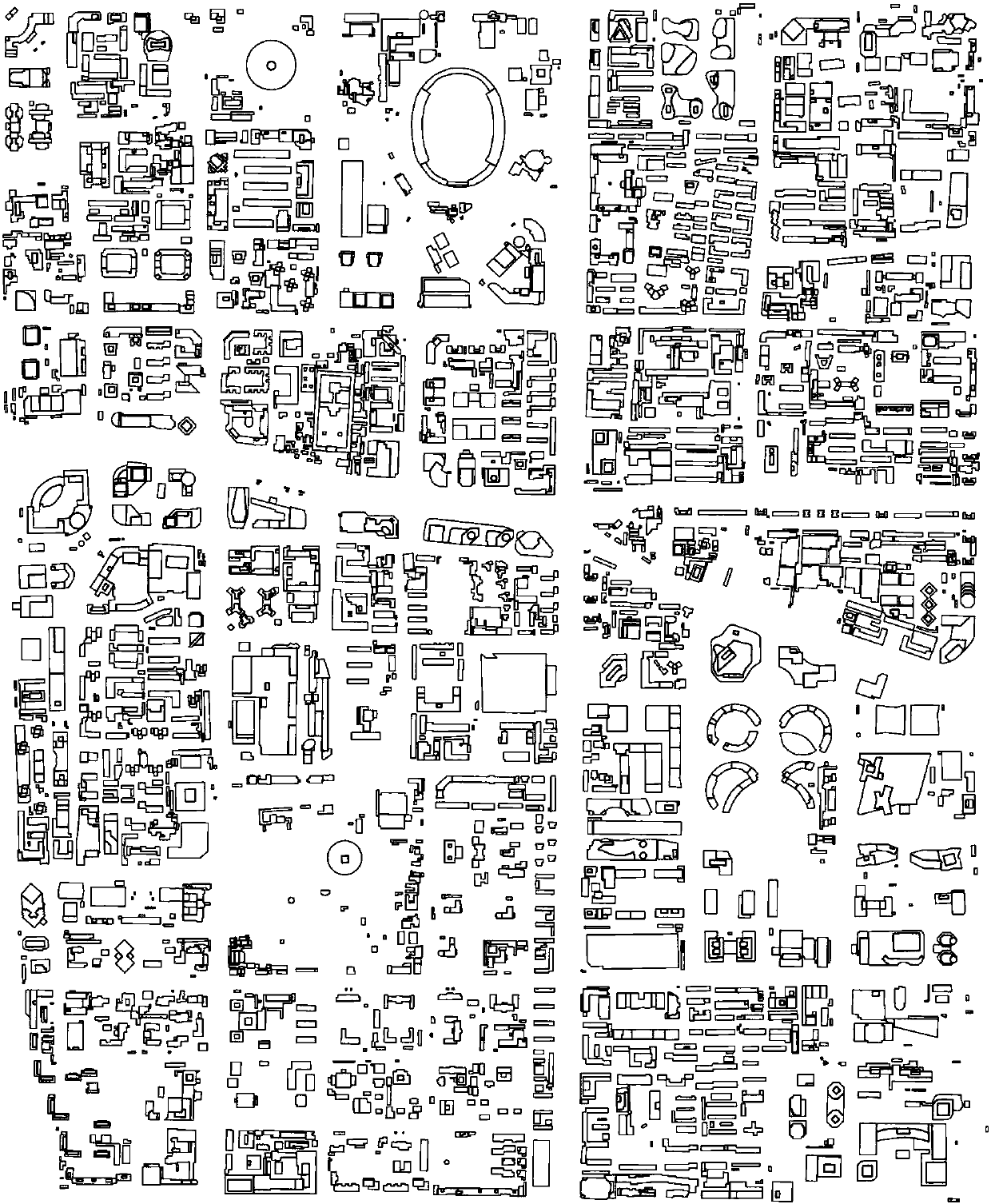
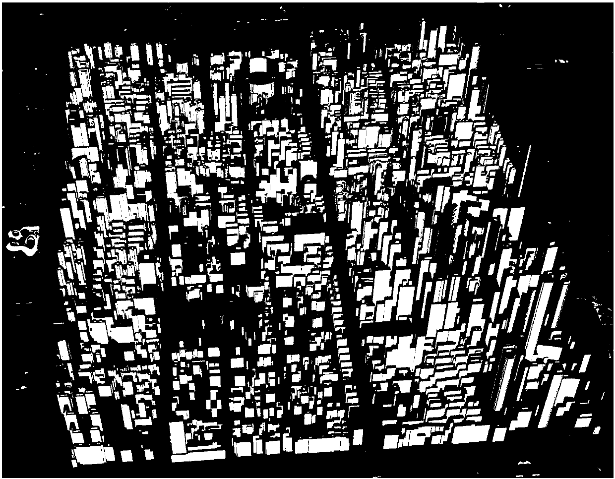
[0027] 2) Step 2: 3D automatic modeling of urban building data

[0028] In the stage of 3D modeling of urban buildings, automatic modeling and color rendering or texture mapping a...


PUM


Abstract

The invention discloses a three-dimensional automatic modeling and visualization method for a city building. In a data preprocessing stage, integrated management is carried out by aiming at multisource data, and the data can be overlapped in three-dimensional digital globe software to be displayed. In the three-dimensional modeling stage of the city building, according to building vector data andattribute information thereof, automatic modeling or color rendering or texture mapping is carried out. In the loading and dynamic visualization stage of a three-dimensional building model, on the basis of a LOD (Limit Of Detection) storage model, a quadtree index and a caching technology, quick data reading and rendering can be realized. Finally, in a comprehensive application stage of earthquakeprevention and disaster reduction, earthquake emergency and earthquake damage prediction application requirements are combined and can be directly integrated into a corresponding business applicationsystem to be used. Under a large-range city scene condition, the three-dimensional quick and automatic modeling and visualization of the building can be realized, and the problem of the three-dimensional visualization expression of the earthquake disaster situation of the city building.

Description

technical field [0001] The invention relates to a three-dimensional automatic modeling and visualization method for urban buildings, which belongs to the interdisciplinary technical field of earthquake prevention and disaster reduction and geographic information systems. Background technique [0002] Beijing is the capital of our country, the political center, cultural center, international communication center and technological innovation center of our country. Beijing's urban security and social stability are of great significance. As the capital, Beijing has brought a large concentration of population and wealth, changed the original natural environment and social environment, and magnified the earthquake disaster effect. The background of the earthquake in the Beijing area and the earthquake situation it is facing are also very complicated and severe. [0003] Strong earthquakes in Beijing and its adjacent areas are mainly concentrated in the fault depression area of ​​...

Claims


Application Information

Patent Timeline
IPC IPC(8): G06T17/00G06Q10/06G06F17/30
Inventor 谭庆全刘群薄涛王治国罗桂纯郁璟贻陈亚男李春连刘英华谢鸿臻
Owner EARTHQUAKE ADMINISTRATION OF BEIJING MUNICIPALITY
Why Eureka
Try Eureka