Airborne LiDAR point cloud roof patch segmentation method and system

A roof surface and point cloud technology, applied to radio wave measurement systems, 3D modeling, 3D image processing, etc., can solve problems such as uneven distribution of point cloud data, difficulty in calculating local features of point cloud, unstructured, etc.

Inactive Publication Date: 2018-01-30
WUHAN UNIV
View PDF3 Cites 13 Cited by
  • Summary
  • Abstract
  • Description
  • Claims
  • Application Information

AI Technical Summary

Problems solved by technology

However, the point cloud data acquired by airborne LiDAR is often unevenly distributed, and the distribution density on the roof surface of the building is much greater than that on the building facade. In the general point cloud neighborhood system, it is difficult to choose a global and general calculation method to calculate Point Cloud Local Features
Therefore, a re

Method used


Image

  • Airborne LiDAR point cloud roof patch segmentation method and system
  • Airborne LiDAR point cloud roof patch segmentation method and system
  • Airborne LiDAR point cloud roof patch segmentation method and system

Examples


Embodiment Construction

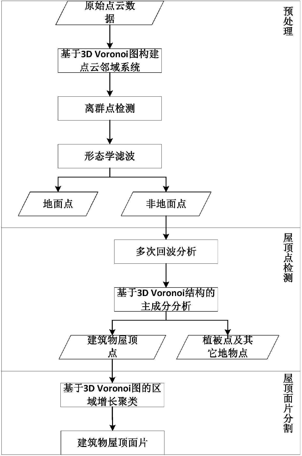
[0051] The technical solution of the present invention will be specifically described below in conjunction with the accompanying drawings and embodiments.

[0052] The invention proposes to apply the 3D Voronoi diagram to the construction of the airborne LiDAR point cloud neighborhood relationship. For a set of points in three-dimensional space, the cell space of each point is defined as the space that is closer to the point than to other points. The point cloud space is subdivided according to the above rules. From a geometric point of view, the vertical bisector between any two points is found to form the 3D Voronoi subdivision of the point cloud. Voro++ is an open source library for constructing 3D Voronoi subdivision, which is easy to use. The present invention intends to complete the following contents in conjunction with the 3DVoronoi diagram:

[0053] (1) Construction of LiDAR point cloud data neighborhood system based on 3D Voronoi diagram

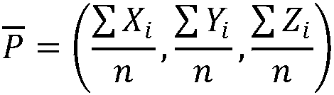
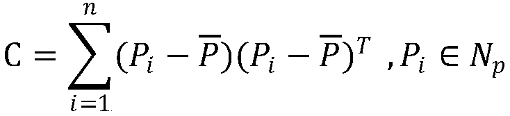
[0054] The present inven...


PUM


Abstract

The invention provides an airborne LiDAR point cloud roof patch segmentation method and system. Based on a 3D Voronoi diagram, airborne LiDAR point cloud roof patch segmentation is carried out. The method comprises the steps that a point cloud neighborhood system is built based on the 3D Voronoi diagram for airborne LiDAR point cloud data; outlier detection is carried out, and outliers are deleted; morphological filtering is used to separate ground points and non-ground points in the point cloud data; the difference between a building and vegetation in multiple echo information of the point cloud data is used to initially distinguish building points and vegetation points to acquire initial building point cloud; based on a 3D Voronoi neighborhood, vegetation points and fracture line pointson the ridge of the building are removed from the initial building point cloud; the characteristic that a building wall normal vector is perpendicular to the direction of a plumb line is used to remove the wall points of the building to acquire the roof points of the building; and based on the 3D Voronoi neighborhood connectivity, the final building roof patch is acquired through area growth.

Description

technical field [0001] The invention belongs to the technical field of airborne laser LiDAR data processing, and relates to an airborne LiDAR point cloud roof patch segmentation method and system based on a 3D Voronoi diagram. Background technique [0002] Airborne LiDAR measurement (Light Detection and Ranging, LIDAR for short), as an emerging space-to-earth observation technology, has produced a major breakthrough in the real-time acquisition of three-dimensional spatial information. The airborne laser radar measurement system integrates the three technologies of laser scanner, global positioning system and inertial navigation system. It measures the target's azimuth, distance and target surface by actively emitting laser light and receiving the target's reflection and scattered echo of the laser beam. It can quickly obtain accurate high-resolution digital ground models and three-dimensional coordinates of ground objects. In recent years, with the development of related t...

Claims


Application Information

Patent Timeline
IPC IPC(8): G06T15/00G06T17/00G01S17/06G01S17/89
Inventor 邵振峰张程
Owner WUHAN UNIV
Why Eureka
Try Eureka