Method and system for monitoring urban heat island effect based on domestic satellite

An urban heat island effect, a domestically produced technology, applied in radiation pyrometry, measurement devices, climate change adaptation, etc., can solve the problems of no research system, only focus on surface temperature inversion, etc., and achieve the effect of quantitative monitoring

Inactive Publication Date: 2018-02-09
SHENZHEN INST OF ADVANCED TECH
View PDF0 Cites 17 Cited by
  • Summary
  • Abstract
  • Description
  • Claims
  • Application Information

AI Technical Summary

Problems solved by technology

Third, in previous studies, researchers mostly used domestic satellite data to only focus on surface temperatur

Method used


Image

  • Method and system for monitoring urban heat island effect based on domestic satellite
  • Method and system for monitoring urban heat island effect based on domestic satellite
  • Method and system for monitoring urban heat island effect based on domestic satellite

Examples


Embodiment Construction

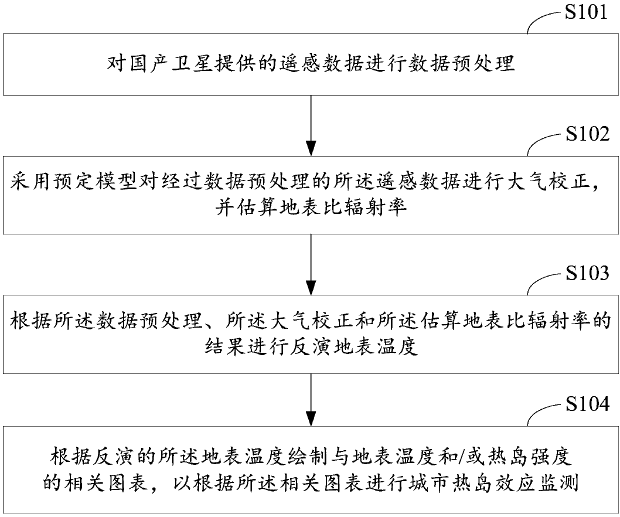
[0026] see figure 1 , is a flow chart of a method for monitoring urban heat island effect based on domestic satellites in an embodiment. This embodiment provides a method for monitoring urban heat island effect based on domestic satellites. The monitoring method includes but is not limited to the following steps.

[0027] Step S101, data preprocessing is performed on the remote sensing data provided by domestic satellites.

[0028] Step S102, using a predetermined model to perform atmospheric correction on the remote sensing data that has undergone data preprocessing, and estimate the surface specific emissivity.

[0029] Step S103, inverting the surface temperature according to the results of the data preprocessing, the atmospheric correction and the estimated surface emissivity.

[0030] Step S104 , drawing a correlation chart with the ground surface temperature and / or heat island intensity according to the retrieved ground surface temperature, so as to monitor the urban he...


PUM


Abstract

The application relates to a method and system for monitoring a urban heat island effect based on a domestic satellite. The monitoring method includes: preprocessing remote sensing data provided by the domestic satellite; performing atmospheric correction on the preprocessed remote sensing data by using a predetermined model, and estimating the earth's surface emissivity; inverting the earth's surface temperature based on the data preprocessing, the atmospheric correction, and the estimated earth's surface emissivity; and drawing a correlation graph corresponding to the earth's surface temperature and/or heat island intensity according to the inverted earth's surface temperature and monitoring the urban heat island effect based on the correlation graph. The method and system can make use of the data of the domestic satellite, quantitatively invert the earth's surface temperature, construct and form a variety of thematic maps and profile maps to realize the quantitative monitoring of the urban heat island effect.

Description

technical field [0001] This application relates to the technical field of heat island effect monitoring, in particular to a domestic satellite-based urban heat island effect monitoring method and system. Background technique [0002] Land surface temperature is a key parameter of radiation and energy exchange between the land surface and the atmosphere, as well as regional and global surface physical processes. Thermal infrared remote sensing is an effective means to detect land surface temperature. Environment-1 Satellite A, B (HJ-A / B) is a brand new civil satellite launched in 2008 by our country after meteorological, oceanographic and land resources satellites. The thermal infrared band spatial resolution of the infrared camera (IRS) on the HJ-1B satellite is 300m. There are not many thermal infrared studies on this star, and they mainly focus on the early stage of model simulation, on-orbit evaluation, or relatively complex inversion process. For example, Duan Sibo et a...

Claims


Application Information

Patent Timeline
IPC IPC(8): G01W1/00G01J5/00
CPCG01J5/007G01W1/00G01J5/804Y02A30/60
Inventor 钱静彭树宏孙博易琳
Owner SHENZHEN INST OF ADVANCED TECH
Why Eureka
Try Eureka