
Rapid identification method of urban low-efficiency industrial land based on electricity consumption data

A technology of electricity consumption data and identification method, which is applied in data processing applications, electrical digital data processing, special data processing applications, etc., and can solve problems such as inefficiency and inefficient research without industrial systems

Active Publication Date: 2018-09-14
SOUTH CHINA UNIV OF TECH
View PDF4 Cites 1 Cited by
  • Summary
  • Abstract
  • Description
  • Claims
  • Application Information

AI Technical Summary

Problems solved by technology

In addition, some scholars use industrial GDP to conduct low-efficiency research on first-class, second-class or certain types of industries, but they have not conducted systematic inefficiency research on industries of different industry categories.

Method used


Image

  • Rapid identification method of urban low-efficiency industrial land based on electricity consumption data
  • Rapid identification method of urban low-efficiency industrial land based on electricity consumption data
  • Rapid identification method of urban low-efficiency industrial land based on electricity consumption data

Examples


Embodiment 1

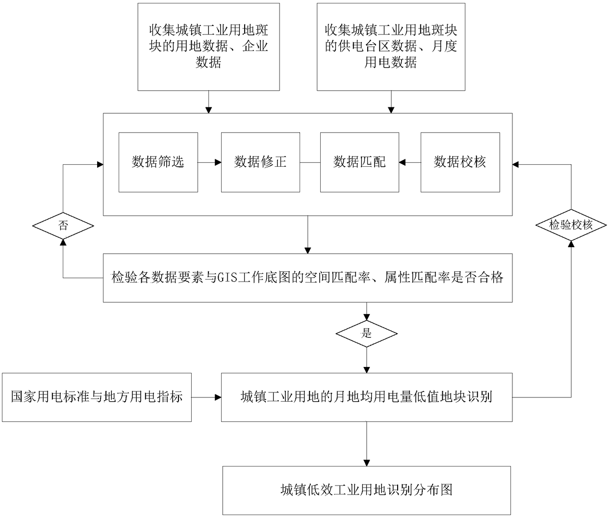
[0098] like figure 1 As shown, this embodiment provides a rapid identification method for urban inefficient industrial land, the method includes the following steps:

[0099] 1) Basic data collection

[0100] 1.1) Collection and verification of working base map

[0101] In this embodiment, the urban construction land patch in the GIS (Geographic Information System, Geographic Information System) land database of the planning and land department is used as the spatial unit for research and analysis. First, the working base map needs to be processed and verified. In the processing of the working base map, the patches of non-industrial land attributes should be deleted, and the patches of urban industrial land attributes should be retained. Since the attribute information of urban industrial land patches is relatively rich, various attribute information of industrial land patches should be integrated in the GIS system to facilitate the identification of urban inefficient indust...

Embodiment 2

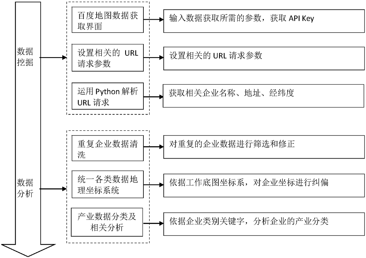
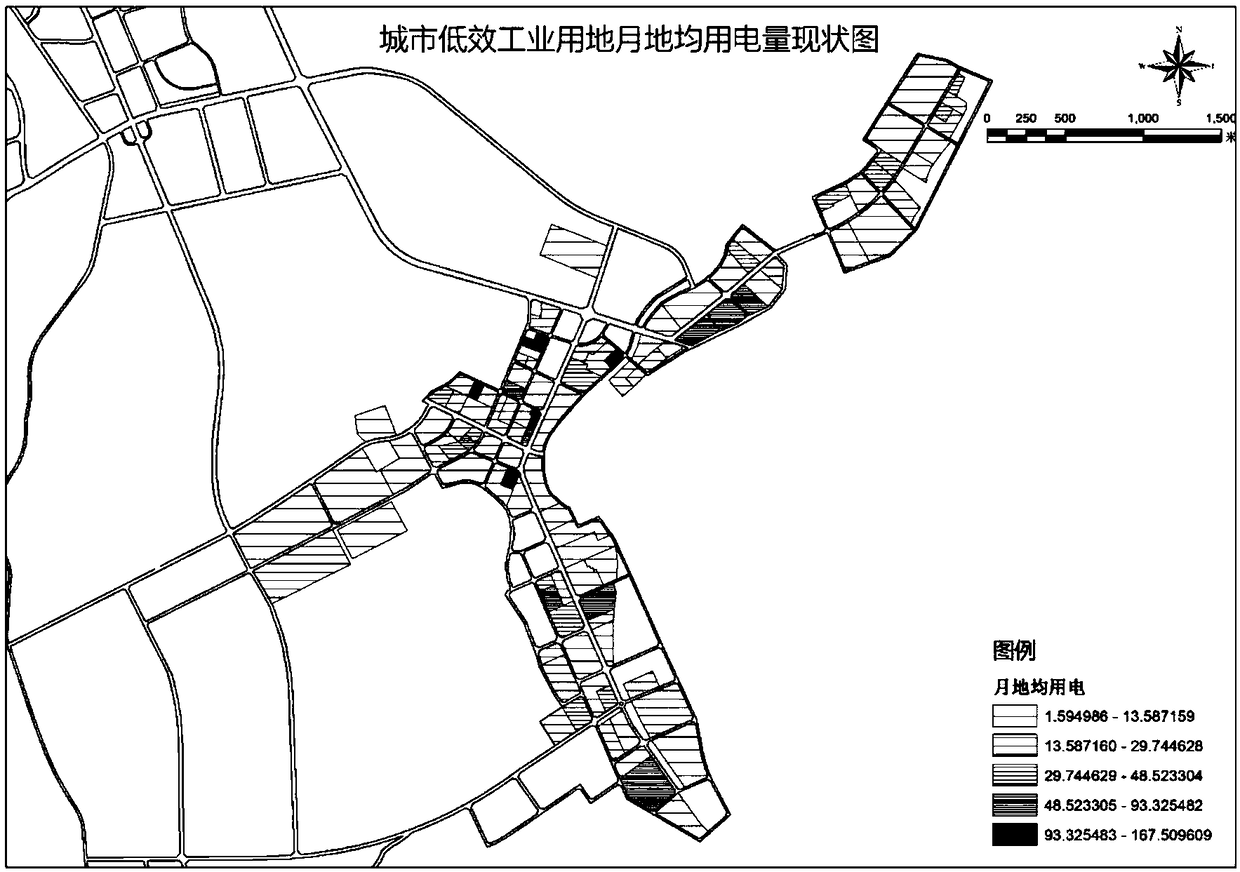
[0158] This embodiment is an application example, taking Wuning County, Jiangxi Province as the operation object, based on the area, nature, boundary, name, development status of the urban industrial land patch in Wuning County, and the enterprise name, address, latitude and longitude in the industrial land patch, Based on the data of the power supply station area and the monthly electricity consumption data, the data processing and data analysis methods of GIS, Python, CAD, and Excel were used to complete the identification of 102 low-efficiency industrial lands, and the potential rating of the inefficient industrial land patches was proposed. The research mainly includes three parts: basic data collection and verification, identification of urban low-efficiency industrial land, and evaluation of urban low-efficiency industrial land redevelopment potential.

[0159] 1) Basic data collection and verification

[0160] First, collect data. Taking the urban industrial land patch...


PUM


Abstract

The invention discloses an electricity consumption data-based method for rapidly recognizing urban low-efficiency industrial lands. The method comprises the following steps of: collecting road trafficnetworks, lands, enterprises, power supply regions and monthly electricity consumption data of urban industrial land plaques; screening elementary data through development statuses and addresses; modifying default and abnormal elementary data through a variable coefficient method, land areas and monthly land average electricity consumption values; matching the elementary data through a high-definition satellite imagery and geographic coordinates; checking the elementary data through a topological relationship and the addresses; and recognizing the plaques, monthly land average electricity consumptions of which are lower than a national electricity consumption standard, so as to generate an urban low-efficiency industrial land recognition and distribution diagram. According to the method,urban low-efficiency industrial lands are recognized on the basis of industrial electricity consumption data, so as to evaluate whether the urban industrial land plaques are sufficiently utilized or not and whether the urban industrial land plaques have re-developing potentials or not, thereby realizing efficient and sustainable utilization of the urban industrial land plaques.

Description

technical field [0001] The invention relates to a method for quickly identifying urban low-efficiency industrial land, in particular to a method for quickly identifying urban low-efficiency industrial land based on electricity consumption data, and belongs to the technical field of urban planning. Background technique [0002] According to the "Analysis Report on China's Land Development Industry Market Prospects and Investment Strategic Planning" by Qianzhan Industrial Research Institute, my country's construction land area expanded from 6,720 square kilometers in 1981 to 49,900 square kilometers in 2014, an increase of 6.44 times, with an average annual growth rate The rate is 6.27%, and the average annual growth area is 1265 square kilometers, showing a clear expansion trend. In addition, data show that the per capita construction area of ​​Chinese cities in 2014 was 129.57 square meters, which greatly exceeded the national standard of 85.1 to 105.0 square meters per perso...

Claims


Application Information

Patent Timeline
Patent Type & Authority Patents(China)
IPC IPC(8): G06F17/30G06Q10/06G06Q50/26
CPCG06F16/215G06F16/2462G06F16/248G06F16/29G06Q10/0639G06Q50/26Y02D10/00
Inventor 邓小兵赵渺希何元权
Owner SOUTH CHINA UNIV OF TECH
Learn More