Unmanned-aerial-vehicle visual-SLAM (Simultaneous Localization and Mapping) method based on binocular camera, unmanned aerial vehicle and storage medium

A technology for binocular cameras and drones, which is applied in image data processing, editing/combining graphics or text, instruments, etc., can solve the problems of simultaneous use of multiple cameras and mutual interference, easy to be interfered by sunlight, etc., so as to solve the problem of interference. The effect of questions, precise maps, precise positioning

Active Publication Date: 2018-03-16
EHANG INTELLIGENT EQUIP GUANGZHOU CO LTD
View PDF3 Cites 42 Cited by
  • Summary
  • Abstract
  • Description
  • Claims
  • Application Information

AI Technical Summary

Problems solved by technology

The existing technology is usually implemented by RGB-D cameras. Since RGB-D cameras use the method of emitting light waves and receiving and returning to measure depth, they are easily disturbed by sunlight when used in outdoor scenes, and multiple cameras are used at the same time. interfere with each other

Method used


Image

  • Unmanned-aerial-vehicle visual-SLAM (Simultaneous Localization and Mapping) method based on binocular camera, unmanned aerial vehicle and storage medium
  • Unmanned-aerial-vehicle visual-SLAM (Simultaneous Localization and Mapping) method based on binocular camera, unmanned aerial vehicle and storage medium
  • Unmanned-aerial-vehicle visual-SLAM (Simultaneous Localization and Mapping) method based on binocular camera, unmanned aerial vehicle and storage medium

Examples


no. 1 example

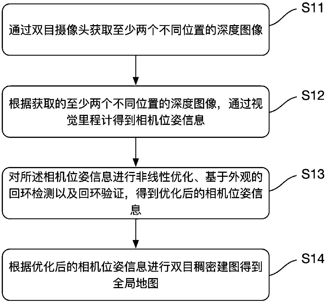
[0034] like figure 1 As shown, the first embodiment of the present invention provides a binocular camera-based UAV visual SLAM method, the method comprising steps:

[0035] S11. Obtain depth images of at least two different positions through a binocular camera.

[0036] In this embodiment, the left and right eye images can be obtained respectively through the binocular camera, and the stereo vision technology is used to calculate the pixel distance through the left and right eye disparity to obtain a depth image, which contains the three-dimensional world coordinate information of all pixels.

[0037] S12. According to the acquired depth images of at least two different positions, the camera pose information is obtained through the visual odometry.

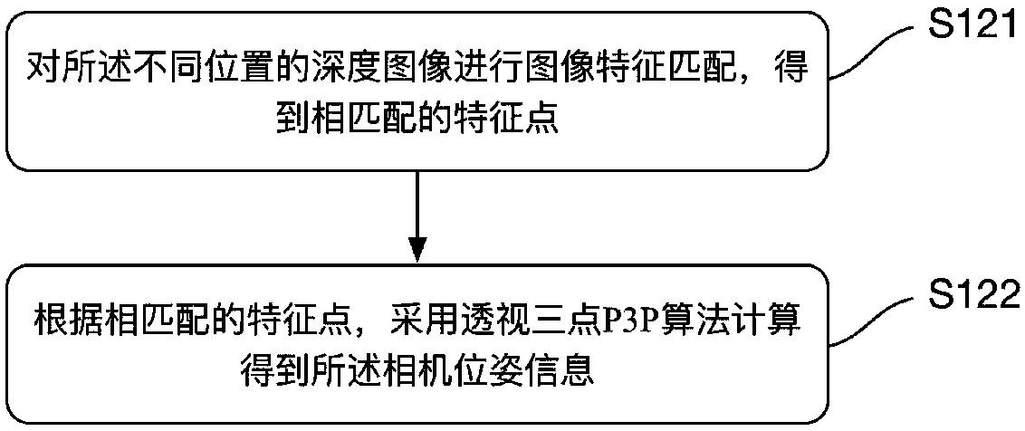
[0038] Please refer to figure 2 As shown, in this embodiment, according to the depth images of the different positions, obtaining the camera pose information through the visual odometer includes steps:

[0039] S121. Perform i...

no. 2 example

[0064] refer to Figure 4 , Figure 4 An unmanned aerial vehicle provided by the second embodiment of the present invention, the unmanned aerial vehicle 20 includes: a memory 21, a processor 22, and a dual-based The UAV visual SLAM program of the eye camera, when the UAV visual SLAM program based on the binocular camera is executed by the processor 22, it is used to realize the UAV visual SLAM method based on the binocular camera as described below A step of:

[0065] S11. Obtain depth images of at least two different positions through a binocular camera;

[0066] S12. According to the acquired depth images of at least two different positions, the camera pose information is obtained through the visual odometry;

[0067] S13. Perform nonlinear optimization, appearance-based loop closure detection and loop closure verification on the camera pose information to obtain optimized camera pose information;

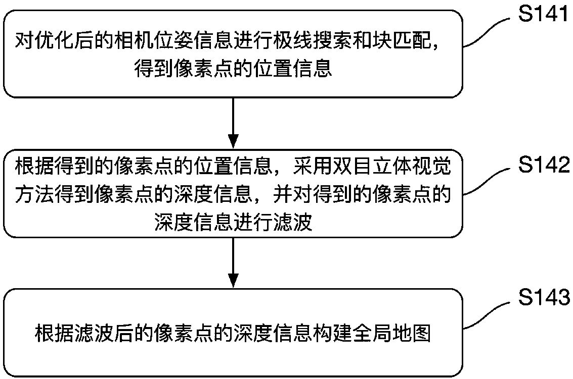
[0068] S14. Perform binocular dense mapping according to the optimized c...

no. 3 example

[0088] The third embodiment of the present invention provides a computer-readable storage medium, the computer-readable storage medium is stored with a UAV visual SLAM program based on a binocular camera, and the UAV visual SLAM program based on a binocular camera When executed by the processor, the steps of the binocular camera-based UAV visual SLAM method described in the first embodiment are realized.

[0089] The computer-readable storage medium provided by the embodiment of the present invention obtains depth images at different positions through a binocular camera, and performs binocular dense mapping to obtain a global map after visual odometer, nonlinear optimization, loopback detection, and loopback verification; On the one hand, it can solve the interference problem of using RGB-D cameras, on the other hand, it can obtain more accurate positioning and establish a more accurate map.


PUM


Abstract

The invention discloses an unmanned-aerial-vehicle visual-SLAM (Simultaneous Localization and Mapping) method based on a binocular camera, an unmanned aerial vehicle and a computer-readable storage medium. The method includes the steps of: acquiring depth images of at least two different locations through the binocular camera; obtaining camera pose information through a visual odometer according to the acquired depth images of the at least two different locations; carrying out nonlinear optimization, appearance-based circle loop detection and circle loop verification on the camera pose information to obtain optimized camera pose information; and carrying out binocular dense mapping according to the optimized camera pose information to obtain a global map. According to the method, the depthimages of the different locations are acquired through the binocular camera, and binocular dense mapping is carried out after use of the visual odometer, nonlinear optimization, circle loop detectionand circle loop verification to obtain the global map; and on the one hand, the interference problem existing with adopting of RGB-D cameras can be solved, and on the other hand, more precise localization can be realized, and the more precise map is established.

Description

technical field [0001] The present invention relates to the technical field of unmanned aerial vehicles, in particular to a binocular camera-based unmanned aerial vehicle visual SLAM method, an unmanned aerial vehicle and a computer-readable storage medium. Background technique [0002] A drone is an unmanned aerial vehicle that can be controlled by wireless remote control or programming. In recent years, the application of unmanned aerial vehicle (UAV) in military and civilian fields has attracted widespread attention. For example, in the military, it can be used for reconnaissance, monitoring, and small-scale attacks; in civilian use, it can be used for aerial photography, surveying and mapping, remote sensing, pesticide spraying, high-voltage transmission line inspection, and earthquake rescue. As a kind of small UAV, quadrotor UAV has outstanding advantages such as strong maneuverability, simple structure design and high safety, and it can approach the target at close r...

Claims


Application Information

Patent Timeline
Patent Type & Authority Applications(China)
IPC IPC(8): G06T11/60G06T7/55
CPCG06T11/60G06T2207/10032G06T7/55
Inventor 胡华智刘剑孙海洋
Owner EHANG INTELLIGENT EQUIP GUANGZHOU CO LTD
Why Eureka
Try Eureka