Solar tdoa measurement method and integrated navigation method for formation flight

A technology of formation flight and integrated navigation, applied in the field of autonomous navigation of formation flight, can solve the problems to be improved and limited navigation accuracy, and achieve the effect of great application significance, market value and high precision

Inactive Publication Date: 2021-07-20
WUHAN UNIV OF SCI & TECH
View PDF6 Cites 0 Cited by
  • Summary
  • Abstract
  • Description
  • Claims
  • Application Information

AI Technical Summary

Problems solved by technology

Xiong Kai combines pulsar navigation and inter-satellite links to improve relative navigation accuracy, but relative navigation accuracy is still limited and needs to be improved

Method used


Image

  • Solar tdoa measurement method and integrated navigation method for formation flight
  • Solar tdoa measurement method and integrated navigation method for formation flight
  • Solar tdoa measurement method and integrated navigation method for formation flight

Examples


Embodiment Construction

[0043] The technical solutions of the present invention will be clearly and completely described below in conjunction with the embodiments of the present invention and the accompanying drawings.

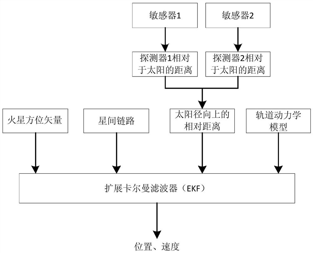
[0044] An embodiment of the present invention provides a solar TDOA measurement method for formation flight, comprising the following steps,

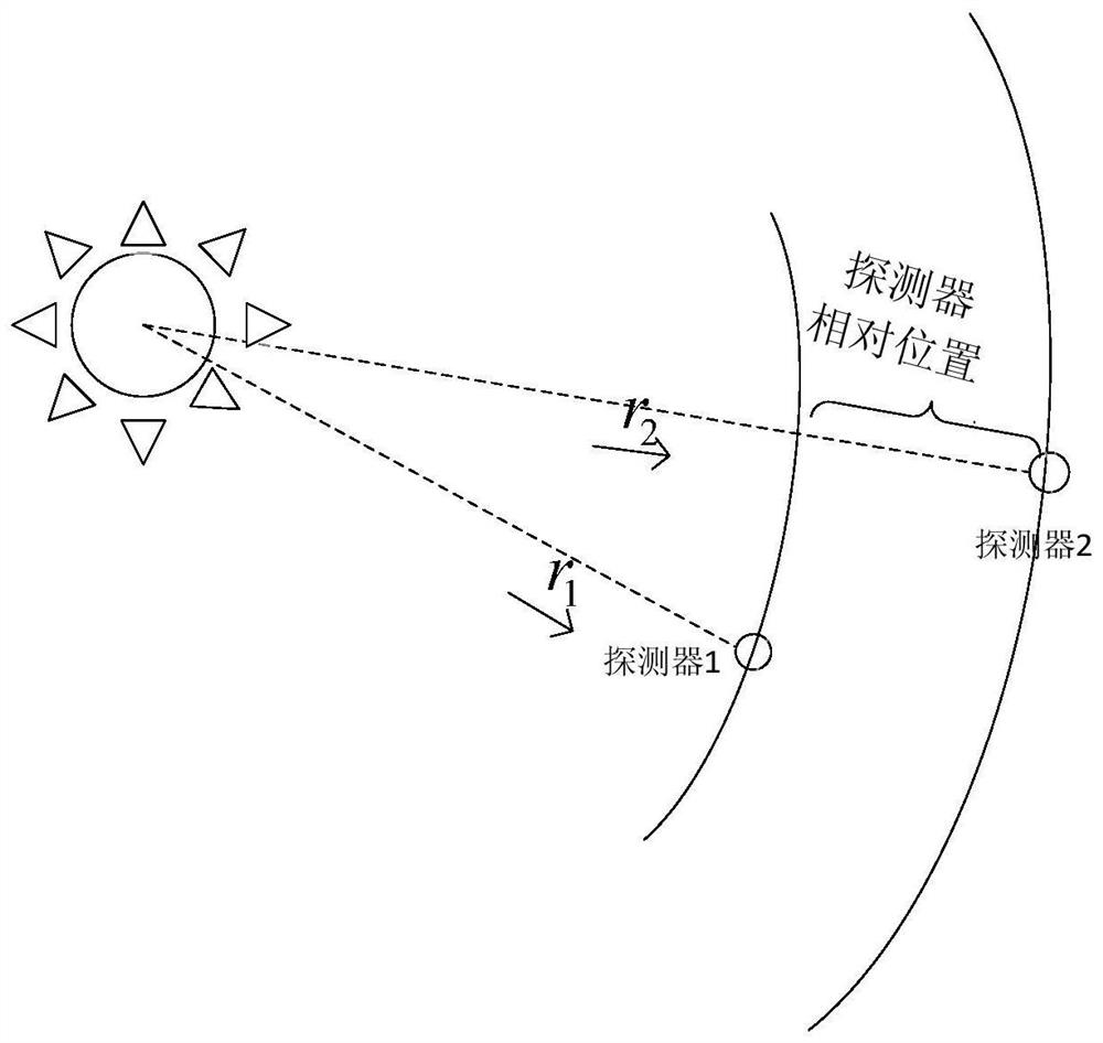
[0045] Step A1, establish the solar TDOA (difference of photon arrival time measured by the detectors flying in formation) measurement model as follows,

[0046] Z 1 (t)=h 1 [X(t),t]+V 1 (t) (Formula 1)

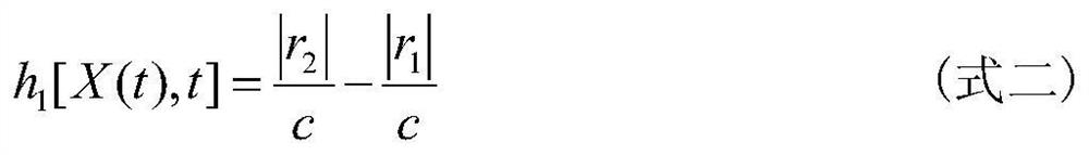
[0047] where Z 1 (t) is the measured value of the relative distance between the two detectors in the radial direction of the sun, V 1 (t) is the measurement noise, h 1 [X(t),t] is the measurement equation, X(t) is the state vector of the detector, t is time, h1 [X(t),t] is expressed as follows,

[0048]

[0049] Among them, c is the speed of light in vacuum, |r 1 |and|r 2 | are the distances between the two detectors in the solar ...


PUM


Abstract

The present invention discloses a solar TDOA measurement method and an integrated navigation method oriented to formation flight, including establishing a solar TDOA measurement model as follows, executing an orbital dynamics model oriented to formation flight for detectors in formation flight, and establishing a Mars direction measurement model , establish the inter-satellite link ranging model; use the extended Kalman filter EKF as the navigation filter, use the star sensor to obtain the celestial body orientation information, the inter-satellite link measurement value and the relative distance in the radial direction of the sun, combined with the formation The orbital dynamics model of the flying probe, under the action of the EKF, obtains the estimated position and velocity information of the probe. The present invention proposes a solar TDOA measurement technical solution for formation flight, which can provide relative position information in the radial direction; the present invention makes full use of a variety of navigation measurement information, and can be used for formation flight in the entire space The sensor provides absolute and relative navigation information with higher accuracy.

Description

technical field [0001] The invention belongs to the field of autonomous navigation of spacecraft, and in particular relates to a technical solution for autonomous navigation of formation flight based on astronomical direction-finding and ranging information. Background technique [0002] Formation flight is a new field in aerospace technology. Flying in formation can increase redundancy, reduce costs, and provide a multi-point platform. In the field of deep space exploration formation flight, both absolute and relative navigation accuracy are very important, especially relative navigation accuracy. [0003] The autonomous navigation of deep space exploration often uses the measurement information of the sun for navigation, including angle measurement, velocity measurement and distance measurement. Solar angle measurement navigation uses the sun's azimuth vector as the measurement information. This method is the most traditional, but the distance between the probe and the s...

Claims


Application Information

Patent Timeline
Patent Type & Authority Patents(China)
IPC IPC(8): G01C21/02G01C21/24
CPCG01C21/02G01C21/24
Inventor 刘劲韩雪侠喻子原陈璇康志伟吴谨
Owner WUHAN UNIV OF SCI & TECH
Why Eureka
Try Eureka