Method for rapidly extracting same name point information of unmanned aerial vehicle images in coastal zone

An extraction method and technology for coastal zones, which are applied in the field of rapid extraction of point information with the same name from UAV images in coastal zones, can solve problems such as insufficient automation, and achieve the effects of good data processing capability, high computing efficiency, and strong versatility.

Active Publication Date: 2018-03-27
THE CHINESE PEOPLES LIBERATION ARMY 92859 TROOPS
View PDF13 Cites 1 Cited by
  • Summary
  • Abstract
  • Description
  • Claims
  • Application Information

AI Technical Summary

Problems solved by technology

[0007] The purpose of the present invention is to overcome the deficiencies in the prior art, and provide a method for quickly extracting the same-name point information of UAV images in the coastal zone

Method used


Image

  • Method for rapidly extracting same name point information of unmanned aerial vehicle images in coastal zone
  • Method for rapidly extracting same name point information of unmanned aerial vehicle images in coastal zone
  • Method for rapidly extracting same name point information of unmanned aerial vehicle images in coastal zone

Examples


Embodiment Construction

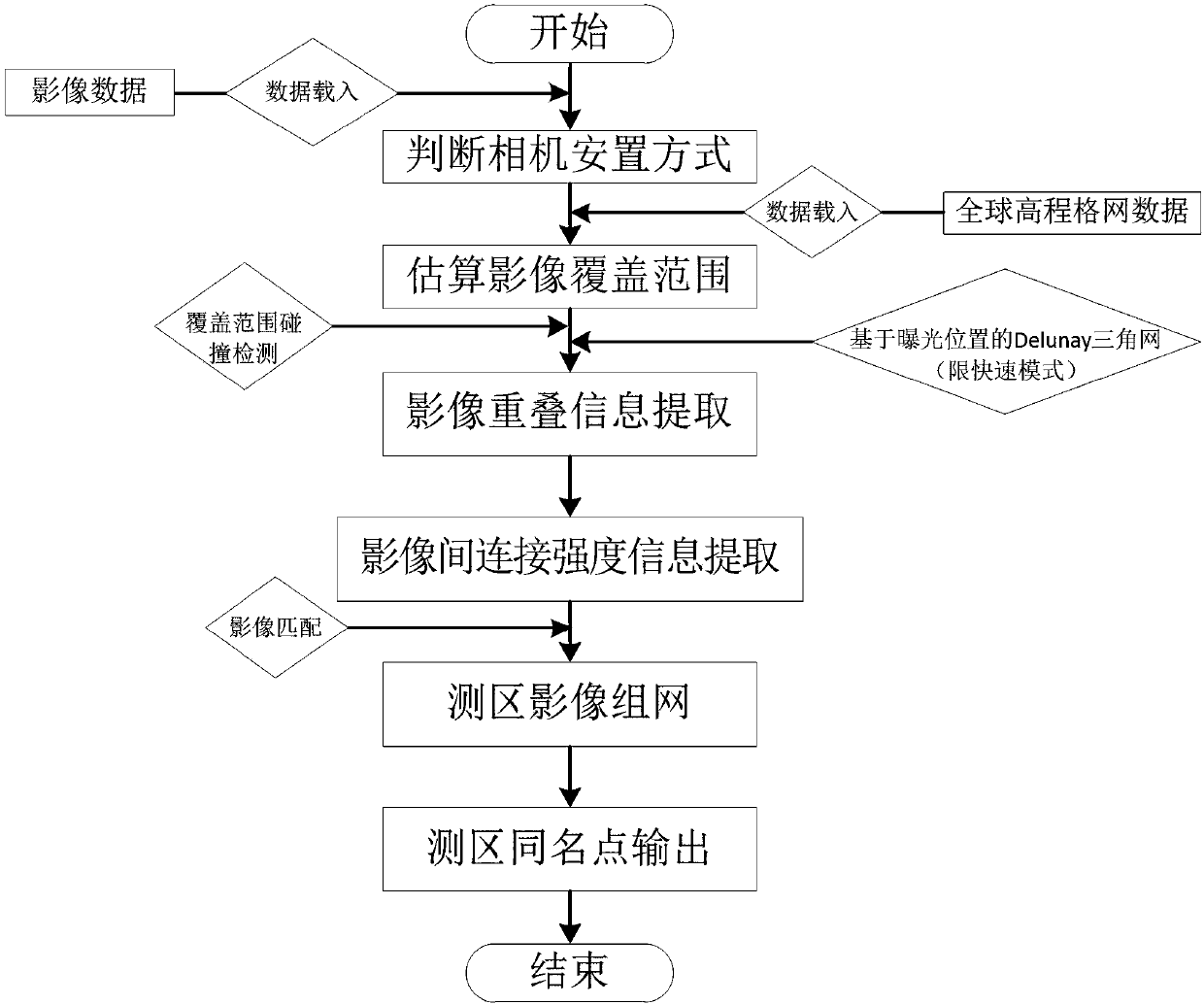
[0042] Embodiments of the present invention are described in further detail below in conjunction with the accompanying drawings:

[0043] A method for quickly extracting the same-name point information from UAV images in the coastal zone, such as figure 1 shown, including the following steps:

[0044] Step 1. Automatically determine the camera placement method based on the image data

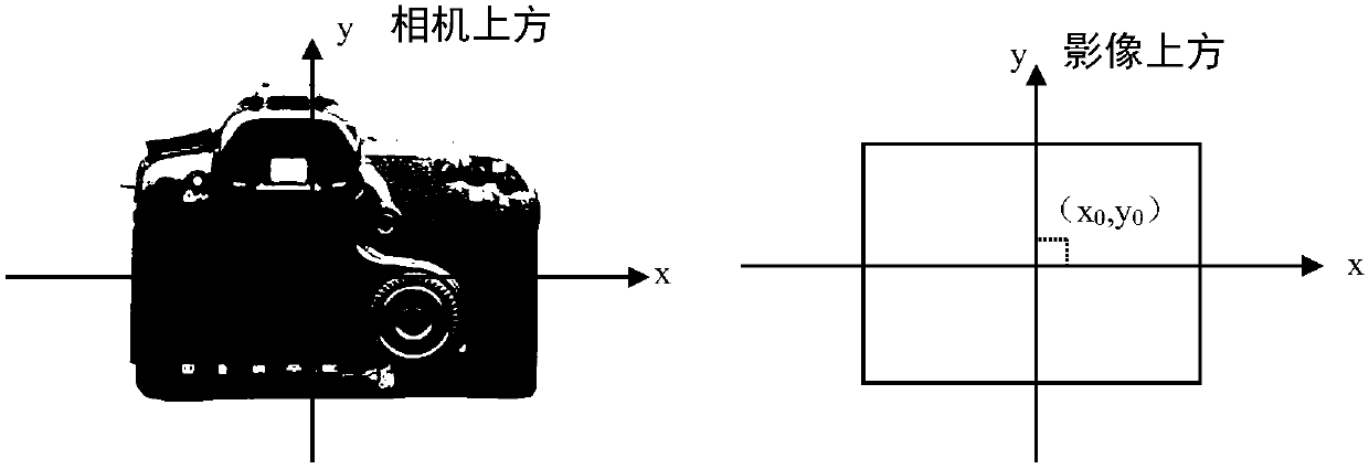
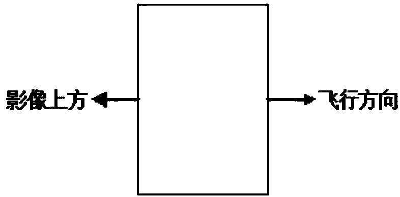
[0045] For UAV surveying and mapping, camera placement should comply with the provisions of the "Low Altitude Digital Photogrammetry Specifications". The specification gives four camera placement methods, such as figure 2 and Figure 3a , Figure 3b , Figure 3c , Figure 3d shown.

[0046] In the same route, the "movement" in four different directions, downward, upward, right, and left, appeared in the first photo taken with the object of the same name compared to the later photo taken. Assuming that the image plane coordinates of any image point with the same name in the image pair ar...


PUM


Abstract

The invention relates to a method for rapidly extracting same name point information of unmanned aerial vehicle images in a coastal zone. The method comprises automatically determining a camera placement mode according to image data, estimating an image ground coverage range according to the global elevation grid data, carrying out coarse extraction on the image overlapping information, extractingconnection strength information between the images, networking the measurement zone images according to the impact matching results and producing and outputting the measurement zone same name point.The method can analyze image overlapping information according to the unmanned aerial vehicle image characteristics in the coastal zone, efficiently provides the same name point information for the subsequent aerial triangulation, utilizes a processing algorithm with a high parallelism degree, has a good data processing capability, utilizes a multi-threaded parallel technology in production of image thumbnails and grayscale images and image feature point extraction and matching and has high calculation efficiency.

Description

technical field [0001] The invention belongs to the technical fields of photogrammetry, remote sensing, and marine surveying and mapping, and relates to post-processing technology of unmanned aerial vehicle image data, especially a method for quickly extracting the same-name point information of unmanned aerial vehicle images in coastal areas Background technique [0002] With the development of human beings and the progress of society, people pay more and more attention to marine resources. In the ocean, which accounts for 71% of the earth's surface area and has a volume of 1.4 billion cubic kilometers, there are extremely rich biological resources and mineral resources. The ocean not only provides human beings with rich material resources, but also has an important strategic position in modern warfare. my country is a large ocean country with a coastline of 18,000 kilometers and a land area of ​​3 million square kilometers. The development of the ocean and the exploration...

Claims


Application Information

Patent Timeline
IPC IPC(8): G01C11/04G06F17/30
CPCG01C11/04G06F16/5838G06F16/5866
Inventor 闸旋申家双滕惠忠辛宪会郭忠磊叶秋果王耿锋
Owner THE CHINESE PEOPLES LIBERATION ARMY 92859 TROOPS
Why Eureka
Try Eureka