Robust multi-mode remote sensing image matching method and system

A remote sensing image and matching method technology, applied in the field of satellite image processing, can solve the problems of low computational efficiency and difficulty in reflecting the common attributes of multimodal images well.

Active Publication Date: 2018-04-13
SOUTHWEST JIAOTONG UNIV
View PDF6 Cites 6 Cited by
  • Summary
  • Abstract
  • Description
  • Claims
  • Application Information

AI Technical Summary

Problems solved by technology

Nevertheless, HOG and LSS only use the local information of the image to construct features, or use the neighborhood information of the extracted feature points to calculate fea

Method used


Image

  • Robust multi-mode remote sensing image matching method and system
  • Robust multi-mode remote sensing image matching method and system
  • Robust multi-mode remote sensing image matching method and system

Examples


Embodiment Construction

[0071] In order to make those skilled in the art better understand the technical solution of the present invention, the technical solution of the present invention is clearly and completely described below in conjunction with the accompanying drawings of the present invention. Based on the embodiments in this application, those of ordinary skill in the art will Other similar embodiments obtained without creative work shall all fall within the scope of protection of this application.

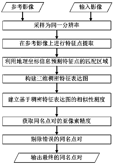
[0072] Such as figure 1 , is a robust multimodal remote sensing image matching method, including the following steps:

[0073] Step A, according to the resolution information of the reference image and the input image, it is judged whether the resolutions of the two images are consistent, if they are consistent, follow-up processing is performed, and if they are inconsistent, the two images are sampled according to the same resolution.

[0074] Step B, using the block strategy, using the Harris ...


PUM


Abstract

The invention discloses a robust multi-mode remote sensing image matching method and system, and various local feature descriptors are integrated to carry out multi-mode remote sensing image automaticmatching. The method comprises firstly, carrying out dense grid sampling on images, extracting a local feature descriptor of each lattice point to form a three-dimensional dense feature expression graph, and then establishing a fast matching similarity measurement in a frequency domain by utilizing a three-dimensional Fourier transform on the basis of the feature expression graph, and finally, carrying out homonymous point identification by means of the template matching. In addition, the invention further provides a new dense feature expression method channel feature of oriented gradient (CFOG) according to the matching method, the channel feature of oriented gradient (CFOG) is superior to the existing dense feature expression modes based on HOG, LSS, SIFT, SURF in the aspects of matching performance and calculation efficiency. According to the invention, the non-linear radiation difference of multi-mode images of the visible light, the infrared ray, the laser radar, the synthetic aperture radar and the map can be effectively overcome, the homonymous point can be rapidly and accurately identified among the images, and the automatic matching of the images can be realized.

Description

technical field [0001] The invention relates to the technical field of satellite image processing, in particular to a multimodal remote sensing image matching method and system for automatic matching of multimodal images such as visible light, infrared, laser radar, contract aperture radar, and maps. Background technique [0002] Image matching is the process of identifying points with the same name between two or more images. It is the basic preprocessing step of many remote sensing image analyzes such as image fusion, change detection, image mosaic, etc. The matching accuracy is important for subsequent analysis work. influences. At present, remote sensing satellite sensors are equipped with global positioning system and inertial navigation system, which can directly locate and roughly match remote sensing images, eliminate obvious rotation and scale changes between images, so that only a certain amount (such as within dozens of pixels) exists between images translation d...

Claims


Application Information

Patent Timeline
IPC IPC(8): G06K9/00G06K9/46
CPCG06V20/13G06V10/443
Inventor 叶沅鑫
Owner SOUTHWEST JIAOTONG UNIV
Why Eureka
Try Eureka