Satellite navigation signal simulation method specific to terminal carrier used as high rail satellite

A technology of satellite navigation signals and high-orbit satellites, which is applied in the field of satellite navigation, can solve problems such as weak signal strength received by high-orbit receivers, ionospheric errors, tropospheric errors, and large variations, so as to improve simulation accuracy, improve accuracy, The effect of improving accuracy

Active Publication Date: 2018-05-04
BEIJING SATELLITE INFORMATION ENG RES INST
View PDF7 Cites 5 Cited by
  • Summary
  • Abstract
  • Description
  • Claims
  • Application Information

AI Technical Summary

Problems solved by technology

It is mainly reflected in the following three aspects: ① The altitude angle of the navigation star relative to the high-orbit receiver is less than 0°; ② Since most of the GNSS signals that the high-orbit receiver may capture come from the navigation star on the back of the earth, the earth’s occlusion and signal propagation process The loss in the high-orbit receiver leads to weak signal strength received by the high-orbit receiver; ③ part of the GNSS signal will pass through the earth’s ionosphere and troposphere twice to reach the high-orbit GNSS receiver, resulting in greater ionospheric and tropospheric errors, that is, the double atmosphere effect

Method used


Image

  • Satellite navigation signal simulation method specific to terminal carrier used as high rail satellite
  • Satellite navigation signal simulation method specific to terminal carrier used as high rail satellite
  • Satellite navigation signal simulation method specific to terminal carrier used as high rail satellite

Examples


Embodiment Construction

[0056] Hereinafter, the present invention will be described in detail based on the drawings.

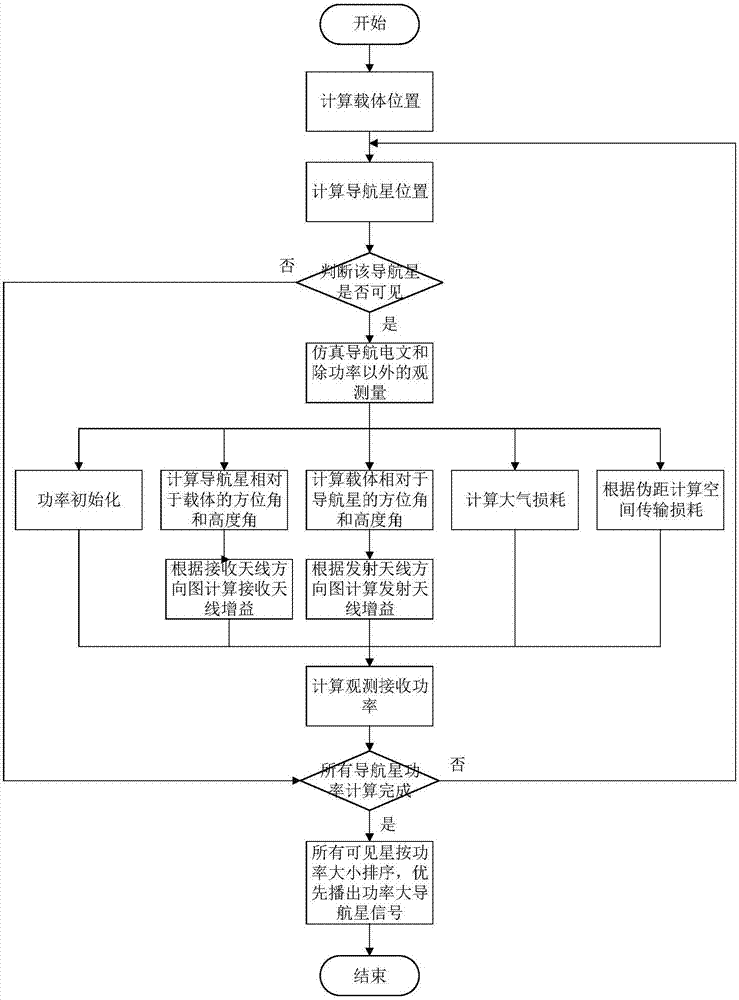
[0057] The satellite navigation signal simulation method aimed at the terminal carrier of the present invention as a high-orbit satellite, such as figure 1 As shown, the specific steps are as follows:

[0058] (1) Generate the position of the high-orbit satellite carrier in the ECEF coordinate system (X u ,Y u ,Z u ).

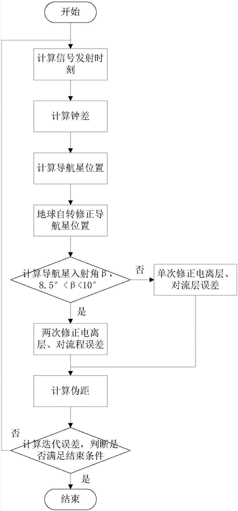
[0059] (2) Calculate the signal transmission time according to the broadcast ephemeris parameters of the set navigation constellation and the simulation time t, and the satellite position of the navigation star is (X s ,Y s ,Z s ), the specific steps are as figure 2 shown.

[0060] a) Set the initial value of the pseudorange pr to 0.07s.

[0061] b) Calculate signal launch time (satellite time) tranT s =t-pr; where pr is pseudorange, unit s; t is simulation time, unit s.

[0062] c) Calculate the clock error clkErr, the clock error is composed of satellite...


PUM


Abstract

The invention provides a satellite navigation signal simulation method specific to a terminal carrier used as a high rail satellite. On the basis of the existing satellite navigation signal simulation, a navigation satellite shielding angle is calculated by adopting a way of an earth tangential line specific to the feature that the elevating angle of the navigation satellite relative to a high track GNSS receiver is less than 0 degree, so as to judge the visibility of the navigation satellite; specific to the feature of weak strength of signals received by the high track GNSS receiver, simulation of a satellite emitting antenna direction graph is added, the power simulation function is improved and the satellite is selected upon power; specific to the feature that a part of signal crossesthrough an atmospheric layer twice, the dual-atmospheric effect simulation is added. Through the method, analogue simulation of the satellite navigation signal received by the high track satellite isrealized, and the testing tool is provided for the GNSS receiver and related system loaded on the high track satellite.

Description

technical field [0001] The invention belongs to the field of satellite navigation, and relates to a method for simulating a satellite navigation signal aimed at a high-orbit satellite as a terminal carrier. Background technique [0002] The global satellite navigation and positioning system has the characteristics of global, all-weather, continuous and high precision. At present, it is widely used in land, ocean, aerospace and other fields. High-altitude orbit satellites (High-Altitude Orbit) include geostationary orbit satellites (Geostationary Orbit, GEO) and large elliptical orbit satellites (Highly Eccentric Orbit, HEO), etc., and the maximum altitude of their orbits is generally higher than 20,000km. With the development of science and technology, high-orbit satellites have important uses in land and ocean communications, weather detection, disaster warning, and space solar stations. [0003] At present, GNSS (Global Navigation Satellite System) receivers for high-orb...

Claims


Application Information

Patent Timeline
Patent Type & Authority Applications(China)
IPC IPC(8): G01S19/37G01S19/23
CPCG01S19/23G01S19/37
Inventor 万程程马文聪邹国际刘杰强隋叶叶王淞波裴峰卢华英吉扬蕾
Owner BEIJING SATELLITE INFORMATION ENG RES INST
Why Eureka
Try Eureka