Remote sensing monitoring method and device for water quality parameters of shallow aquatic plant lake

A water quality parameter and remote sensing monitoring technology, applied in the field of measurement, can solve problems such as difficult to meet water quality monitoring requirements, and achieve the effect of rapid water quality parameter inversion

Active Publication Date: 2018-05-11
INST OF REMOTE SENSING & DIGITAL EARTH CHINESE ACADEMY OF SCI
View PDF3 Cites 42 Cited by
  • Summary
  • Abstract
  • Description
  • Claims
  • Application Information

AI Technical Summary

Problems solved by technology

The particularity of shallow grass-type lakes makes it difficult for traditional inland lake water quality remote sensing monitoring methods to meet the water quality monitoring requirements of the entire lake.

Method used


Image

  • Remote sensing monitoring method and device for water quality parameters of shallow aquatic plant lake
  • Remote sensing monitoring method and device for water quality parameters of shallow aquatic plant lake
  • Remote sensing monitoring method and device for water quality parameters of shallow aquatic plant lake

Examples


Embodiment 1

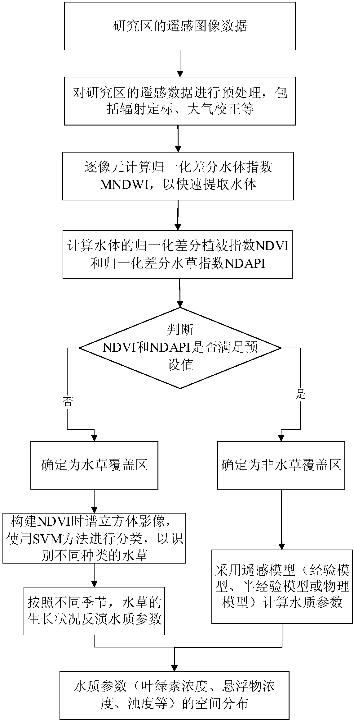
[0056] The inversion area in this example is the Weishan Lake area. Operation process see figure 1 .

[0057] S1 acquires the time-series satellite remote sensing image data of the lake area, and preprocesses the remote sensing image. The preprocessing methods include radiometric calibration, geometric correction, and atmospheric correction, all of which are processed under conventional conditions; use formula (1) to calculate the green band ( 560nm) and short-infrared (such as 1600nm) normalized difference water index MNDWI, the pixels greater than the preset value "0" are extracted as water bodies;

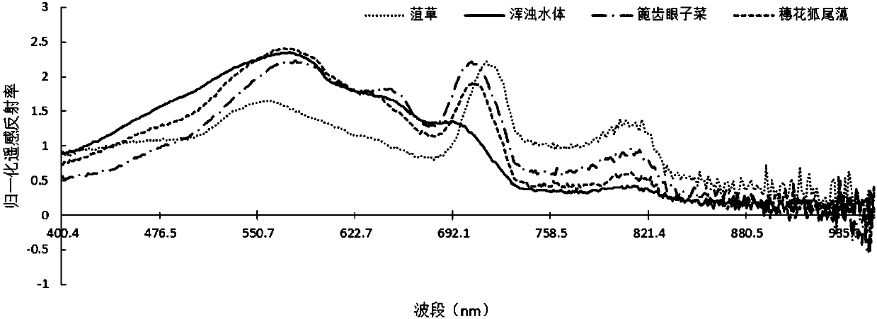
[0058] S2 is extracted as the pixel of the water body, and the normalized difference vegetation index NDVI of the water body is calculated by formula (2), and the calculated wave bands are 670nm and 800nm; (800—820nm) normalized difference aquatic plant index NDAPI of water body, the calculated band takes the reflection peak of 690-720nm and the reflection peak of 800-820nm; t...

Embodiment 2

[0070] Example 2 Remote Sensing Monitoring Device for Water Quality Parameters of Shallow Water Grass Lakes

[0071] Figure 7 It is a schematic structural diagram of a remote sensing monitoring device for water quality parameters of a shallow grass-type lake considering the species and habitat of aquatic plants provided in this embodiment. Such as Figure 7 As shown, the device includes:

[0072] Data preprocessing module, used for preprocessing remote sensing data, including radiometric calibration, geometric correction, atmospheric correction, etc.;

[0073] The index calculation module is used for parameters such as MNDWI, NDVI and NDAPI of remote sensing images, and it includes three modules, namely, the MNDWI calculation module, the NDVI calculation module and the NDAPI calculation module;

[0074] Threshold judgment module, used to judge whether the obtained MNDWI, NDVI and NDAPI meet the preset conditions;

[0075] The classification module of aquatic plant coverag...


PUM


Abstract

The invention provides a remote sensing monitoring method for water quality parameters of a shallow aquatic plant lake. The method comprises the following steps: acquiring time series satellite remotesensing image data of a lake area, and extracting a water body by use of a normalized differential water body index MNDWI; calculating a normalized differential vegetation index NDVI and a normalizeddifferential aquatic plant index NDAPI of the water body to quickly extract an aquatic plant covering zone and aquatic plant growth conditions; building a vegetation index time spectrum cube image ofthe aquatic plant covering zone to realize fine partition of aquatic plant species; using the water quality indication effect of the aquatic plant species and the aquatic plant growth conditions forpartitional and seasonal inversion of the water quality parameters of the aquatic plant covering zone; and forming a spatial distribution map of the water quality parameters. According to the method proposed by the invention, the aquatic plant species on a remote-sensing satellite image can be accurately identified according to unique phenological characteristics of ground features and remote sensing vegetation index time spectrum analysis technology, the water quality parameters of the shallow aquatic plant lake can be simply and quickly inverted.

Description

technical field [0001] The invention belongs to the field of measurement, and in particular relates to a method for obtaining water body property parameters by using satellite remote sensing data. Background technique [0002] There are many shallow lakes with an average water depth of less than 4 meters in the middle and lower reaches of the Yangtze River and the Huanghuaihai Plain in my country. When the water is rich in nutrients and the bottom is silt with many humus, it will cause a large number of aquatic plants to multiply, making these lakes gradually develop into grasslands. type lake. Shallow grass lakes are used as freshwater reservoirs to provide domestic water for urban residents around the lakes. The water quality of these lakes is closely related to people's lives. Therefore, it is very important to monitor the water quality of inland shallow grass lakes. Conventional water quality monitoring requires on-site collection of water samples. For larger lake areas,...

Claims


Application Information

Patent Timeline
Patent Type & Authority Applications(China)
IPC IPC(8): G01N21/25G01N21/17
CPCG01N21/17G01N21/25G01N2021/1797
Inventor 黄长平张立福张霞乔娜岑奕王树东
Owner INST OF REMOTE SENSING & DIGITAL EARTH CHINESE ACADEMY OF SCI
Why Eureka
Try Eureka