An Inertial Navigation Initial Alignment Method for Altitude Sensor-Assisted Pseudo-Lite Positioning

A height sensor and initial alignment technology, which is applied in the field of satellite positioning, can solve the problems of not being able to meet the needs of INS static base alignment, large positioning errors, etc., and achieve the effect of improving pseudolite positioning results

Active Publication Date: 2021-07-13
BEIJING AUTOMATION CONTROL EQUIP INST
View PDF0 Cites 0 Cited by
  • Summary
  • Abstract
  • Description
  • Claims
  • Application Information

AI Technical Summary

Problems solved by technology

However, in reality, if the pseudolite is used alone for positioning, there will be problems such as excessive positioning error, which cannot meet the needs of INS static base alignment. Therefore, a pseudolite positioning method assisted by an altitude sensor is proposed. Using this method, Accurate position information to enable initial alignment to inertial navigation

Method used


Image

  • An Inertial Navigation Initial Alignment Method for Altitude Sensor-Assisted Pseudo-Lite Positioning
  • An Inertial Navigation Initial Alignment Method for Altitude Sensor-Assisted Pseudo-Lite Positioning
  • An Inertial Navigation Initial Alignment Method for Altitude Sensor-Assisted Pseudo-Lite Positioning

Examples


Embodiment Construction

[0035] An initial alignment method for inertial navigation aided by a height sensor for pseudolite positioning, the steps are as follows:

[0036] Step 1. Calculation of the initial position of the inertial navigation package

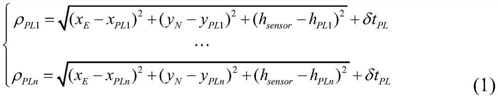
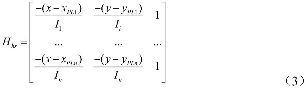
[0037] When the inertial navigation system performs initial alignment, it needs to encapsulate the initial position. In the case of GNSS signal rejection, the initial position of the inertial navigation system is obtained through highly assisted pseudolite positioning. The reason for the poor positioning results of the traditional pseudolite alone is that the VDOP value is too large, resulting in the celestial positioning accuracy not meeting the inertial navigation alignment accuracy requirements. The divergence of positioning results can be avoided by using the height sensor to provide height information. The use of altitude sensors to assist pseudolite positioning needs to improve the positioning equation, and the amount to be solved becomes r PL =...


PUM


Abstract

The invention belongs to the field of satellite positioning, and in particular relates to an inertial navigation initial alignment method with altitude sensor-assisted pseudolite positioning. The method includes step 1, calculation of the initial position of the inertial navigation alignment package, step 2, rough alignment of the inertial navigation, and step 3, fine alignment of the inertial navigation. The method can effectively eliminate the influence of excessive VDOP on the positioning results in pseudolite positioning, and obtain accurate positioning results, so that the positioning results of satellites can meet the requirements of inertial navigation alignment, and the pseudolite positioning results have large errors in the height direction. Can not meet the position requirements of inertial navigation alignment, the error of the pseudolite positioning result of altitude assistance is small, and the three-way errors are all at the meter level, and the altitude assistance can significantly improve the pseudolite positioning result.

Description

technical field [0001] The invention belongs to the field of satellite positioning, and in particular relates to an inertial navigation initial alignment method for height sensor-assisted pseudolite positioning. Background technique [0002] Under the condition of a static base and the position of the carrier is known, the inertial navigation system (INS) can quickly complete the initial alignment, but in the wild environment, when the satellite navigation system (GNSS) system fails seriously, the GNSS will be rejected. Under the conditions, the existing methods cannot guarantee the availability of the GNSS system, cannot obtain the accurate position of the inertial navigation system, and cannot complete the alignment of the INS system. At this time, the INS system needs to complete the initial alignment independently, and it needs the assistance of external information to complete the initial position encapsulation. Pseudo-satellites are simple and quick to lay, and are no...

Claims


Application Information

Patent Timeline
Patent Type & Authority Patents(China)
IPC IPC(8): G01C25/00G01S19/25
CPCG01C25/005G01S19/25
Inventor 管春洋何伟张吉先胡凌周金龙于之音刘洋
Owner BEIJING AUTOMATION CONTROL EQUIP INST
Why Eureka
Try Eureka