An early identification method of loess landslide based on land subsidence information

A land subsidence and early identification technology, which is applied in the direction of surveying instruments, instruments, surveying and navigation, etc., can solve the problems of limited coverage, low degree of automation, and high cost, so as to reduce field workload, improve accuracy, and operate simple effect

Inactive Publication Date: 2020-09-01
CHANGAN UNIV
View PDF3 Cites 0 Cited by
  • Summary
  • Abstract
  • Description
  • Claims
  • Application Information

AI Technical Summary

Problems solved by technology

However, it can only obtain one-dimensional deformation and there are shadows, top-bottom inversion, and perspective shortening, so there will also be missed and wrong judgments on landslides.
Especially for loess landslides with small spatial scales, direct identification based on InSAR deformation is often unsuccessful
[0004] The existing early identification technology of loess landslides is time-consuming, laborious, expensive and limited in coverage
Serious misjudgments and omissions, low degree of automation, positioning only for areas after disasters, unable to meet actual needs

Method used


Image

  • An early identification method of loess landslide based on land subsidence information
  • An early identification method of loess landslide based on land subsidence information

Examples


specific Embodiment approach

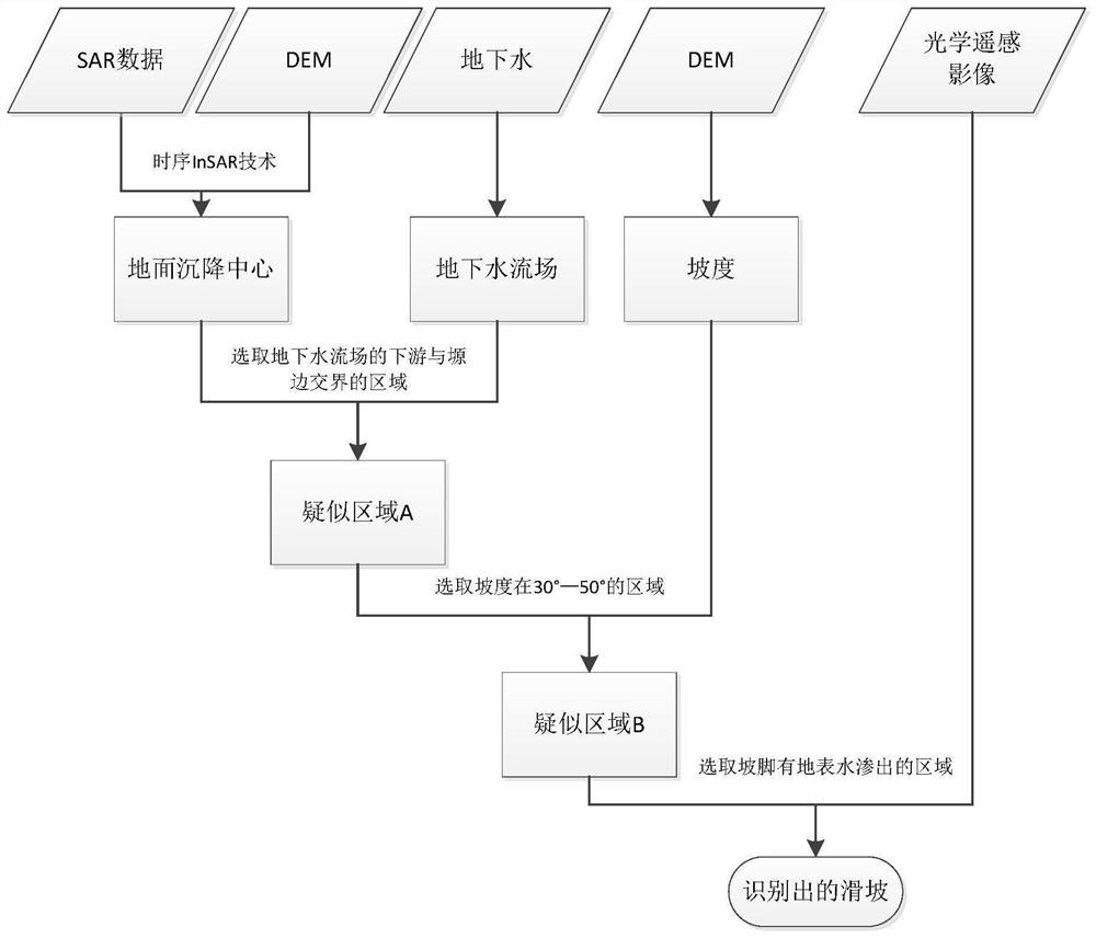
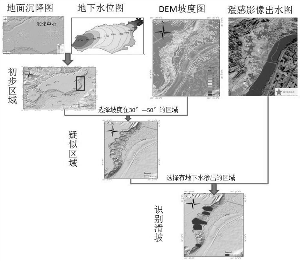
[0030] The specific implementation method is as follows: Interferometric processing is performed on the SAR image of the research area, and the annual rate of ground deformation in the area is obtained by the time-series InSAR method, and then the land subsidence information is obtained. When the land subsidence in the area is caused by the change of groundwater, it is considered that The area has the necessary conditions for landslides within a certain range.

[0031] The next step is to confirm the specific location of the landslide.

[0032] The change of groundwater level is the first condition. When the groundwater level of a certain place has the same change trend as the groundwater level of the ground subsidence center, a landslide may form there, and this area is A.

[0033] Slope and aspect constitute the second condition. The slope requirement of a single landslide is 30°-50°, and the area that meets these conditions is B.

[0034] The third condition is the seepage...


PUM


Abstract

The present invention relates to the technical field of loess landslide identification, and discloses an early identification method for loess landslides based on land subsidence information, comprising the following steps: S1, combining subsidence information and groundwater information to obtain the downstream of the subsidence center groundwater flow field and the boundary of the tableland Area, this area is A; S2, generate a slope map according to the DEM of the research area; the slope requirement of a single landslide is 30°-50°, and the area that meets these conditions in area A is B; S3, obtain the remote sensing image of the research area , to identify the seepage point of the loess tableland and groundwater; the area with groundwater seepage in area B is called C, so that area C is the landslide area that is finally identified. This method is suitable for InSAR identification of landslides and optical remote sensing images The three methods of identifying landslides using DEM and DEM learn from each other, revealing their internal relations and improving the accuracy of loess landslide identification.

Description

technical field [0001] The invention relates to the technical field of loess landslide identification, in particular to an early identification method for loess landslides based on land subsidence information. Background technique [0002] With the rapid development of economy and population, the geological environment in the loess area is becoming more and more fragile, the climate and ecology are deteriorating, human activities are more frequent, and large-scale farmland is flooded, resulting in frequent geological disasters such as ground subsidence, ground fissures, collapses, landslides, and mud flows in the loess area. send. These disasters are caused by each other and evolve from the same source, forming a complex disaster chain, resulting in mass casualties, serious economic losses and endangering major projects. According to incomplete statistics, major disasters frequently occurred in the Loess Plateau region, including 49,000 landslides, more than 31,000 landslid...

Claims


Application Information

Patent Timeline
Patent Type & Authority Patents(China)
IPC IPC(8): G01C15/00
CPCG01C15/00
Inventor 赵超英赵卫锋张勤康亚刘晓杰朱文峰
Owner CHANGAN UNIV
Why Eureka
Try Eureka