GIS based road information visible method, system, and device, and server
A technology of road information and server, applied in the field of GIS-based road information visualization method, device and server, and system, which can solve the problems of inaccurate and inconvenient data
- Summary
- Abstract
- Description
- Claims
- Application Information
AI Technical Summary
Problems solved by technology
Method used
Image

Examples
no. 1 example
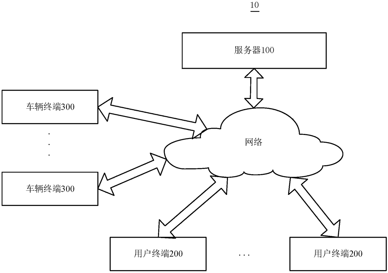
[0035] The first embodiment of the present invention provides a GIS-based road information visualization method, which is applied to a GIS-based road information visualization system. See figure 1 , the GIS-based road information visualization system 10 includes a server 100 , a user terminal 200 and a target terminal 300 , and the user terminal 200 and the target terminal 300 are wirelessly connected to the server 100 .
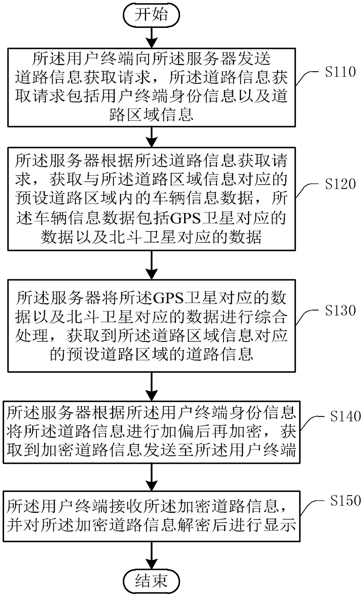
[0036] Such as image 3 A flow chart of a road information visualization method provided by an embodiment of the present invention is shown. See image 3 , the method includes:
[0037] Step S110: the user terminal sends a road information acquisition request to the server, and the road information acquisition request includes user terminal identity information and road area information.
[0038] When the user needs to acquire road information to know the smoothness of the road, the user can input query content through the user terminal 200 , and the use...
no. 2 example
[0079] The second embodiment of the present invention provides a GIS-based road information visualization system 10, please refer to figure 1 , the GIS-based road information visualization system 10 includes a server 100 and a user terminal 200, and the server 100 and the user terminal 200 are wirelessly connected. Wherein, the user terminal 200 is used to send a road information acquisition request to the server 100, and the road information acquisition request includes user terminal identity information and road area information; The vehicle information data in the preset road area corresponding to the road area information, the vehicle information data includes the data corresponding to the GPS satellite and the data corresponding to the Beidou satellite; the server 100 is also used to associate the data corresponding to the GPS satellite and the Beidou satellite The data of the road area is comprehensively processed to obtain the road information of the preset road area co...
no. 3 example
[0082] The third embodiment of the present invention provides a GIS-based road information visualization method, which is applied to a server. Please refer to Figure 7 , the method includes:
[0083] Step S210: Receive a road information acquisition request sent by a user terminal, where the road information acquisition request includes user terminal identity information and road area information.
[0084] Step S220: According to the road information acquisition request, acquire vehicle information data in a preset road area corresponding to the road area information, the vehicle information data including data corresponding to GPS satellites and data corresponding to Beidou satellites.
[0085] Step S230: comprehensively process the data corresponding to the GPS satellites and the data corresponding to the Beidou satellites, and obtain the road information of the preset road area corresponding to the road area information.
[0086] Step S240: According to the identity infor...
PUM
 Abstract
Description
Claims
Application Information
 - R&D
- Intellectual Property
- Life Sciences
- Materials
- Tech Scout
- Unparalleled Data Quality
- Higher Quality Content
- 60% Fewer Hallucinations
Browse by: Latest US Patents, China's latest patents, Technical Efficacy Thesaurus, Application Domain, Technology Topic, Popular Technical Reports.
© 2025 PatSnap. All rights reserved.Legal|Privacy policy|Modern Slavery Act Transparency Statement|Sitemap|About US| Contact US: help@patsnap.com