Parameter optimization method and system for a river water-sediment model
A technology of model parameters and optimization methods, applied in design optimization/simulation, data processing applications, electrical digital data processing, etc., can solve problems such as poor prediction accuracy, achieve accurate reflection, improve sampling efficiency, and improve prediction accuracy.
- Summary
- Abstract
- Description
- Claims
- Application Information
AI Technical Summary
Problems solved by technology
Method used
Image
Examples
Embodiment 1
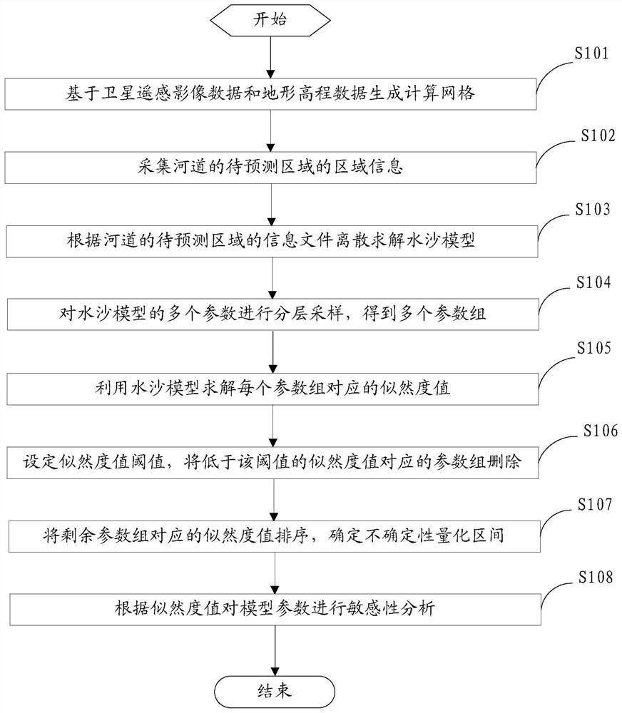
[0047] figure 1 A flow chart of steps for a parameter optimization method of a river water-sediment model provided by an embodiment of the present invention;
[0048] refer to figure 1 As shown, the parameter optimization method provided in this embodiment is used to optimize the parameters of the river water-sediment model, and the specific steps include:
[0049] S101: Generate a computational grid based on satellite remote sensing image data and terrain elevation data.
[0050] Specifically, firstly, based on the satellite remote sensing image data, the water body boundary is extracted, and on this basis, the triangular mesh of the river channel is automatically generated; then, the river channel elevation of the node of the triangular mesh of the river channel is generated by interpolation using the obtained topographic elevation data of the river channel.
[0051] S102: Collect area information of the area to be predicted of the river course.
[0052]The regional infor...
Embodiment 2
[0138] figure 2 A structural block diagram of a parameter optimization system for a river water-sediment model provided by an embodiment of the present invention;
[0139] refer to figure 2 As shown, the parameter optimization system provided by the embodiment of the present invention is used to optimize the parameters of the river water-sediment model, and specifically includes a grid generation module 10, an information collection module 20, a model calculation module 30, a hierarchical sampling module 40, and a likelihood Calculation module 50 , parameter group screening module 60 , uncertainty analysis module 70 , sensitivity analysis module 80 .
[0140] The grid generation module is used to calculate the river channel elevation based on satellite remote sensing image data and terrain elevation data.
[0141] This module includes a planar grid generation unit and an elevation interpolation calculation unit. The grid generation unit is used to extract water body bounda...
PUM
 Abstract
Description
Claims
Application Information
 - R&D
- Intellectual Property
- Life Sciences
- Materials
- Tech Scout
- Unparalleled Data Quality
- Higher Quality Content
- 60% Fewer Hallucinations
Browse by: Latest US Patents, China's latest patents, Technical Efficacy Thesaurus, Application Domain, Technology Topic, Popular Technical Reports.
© 2025 PatSnap. All rights reserved.Legal|Privacy policy|Modern Slavery Act Transparency Statement|Sitemap|About US| Contact US: help@patsnap.com


