Multi-rotor flight-path planning system and method orienting to inspection of power transmission lines

A technology for track planning and power transmission lines, applied in radio wave measurement systems, satellite radio beacon positioning systems, control/regulation systems, etc., can solve poor positioning accuracy, does not consider the terrain characteristics of power transmission lines, geographic elevation tower coordinates, Issues such as autonomous online adjustment of the control strategy of the UAV are not considered to achieve the effect of avoiding collisions

Inactive Publication Date: 2018-07-24
GUIZHOU POWER GRID CO LTD
View PDF10 Cites 22 Cited by
  • Summary
  • Abstract
  • Description
  • Claims
  • Application Information

AI Technical Summary

Problems solved by technology

[0004] (1) The existing method does not consider information such as terrain characteristics, geographic elevation, and tower coordinates of the transmission line during the flight;
[0005] (2) Most of the existing methods for transmission line inspections use ordinary GPS modules, and the positioning accuracy is poor;
[0006] (3) The existing method does not consider the autonomous online adjustment control strategy after the UAV encounters an obstacle

Method used


Image

  • Multi-rotor flight-path planning system and method orienting to inspection of power transmission lines
  • Multi-rotor flight-path planning system and method orienting to inspection of power transmission lines
  • Multi-rotor flight-path planning system and method orienting to inspection of power transmission lines

Examples


Embodiment

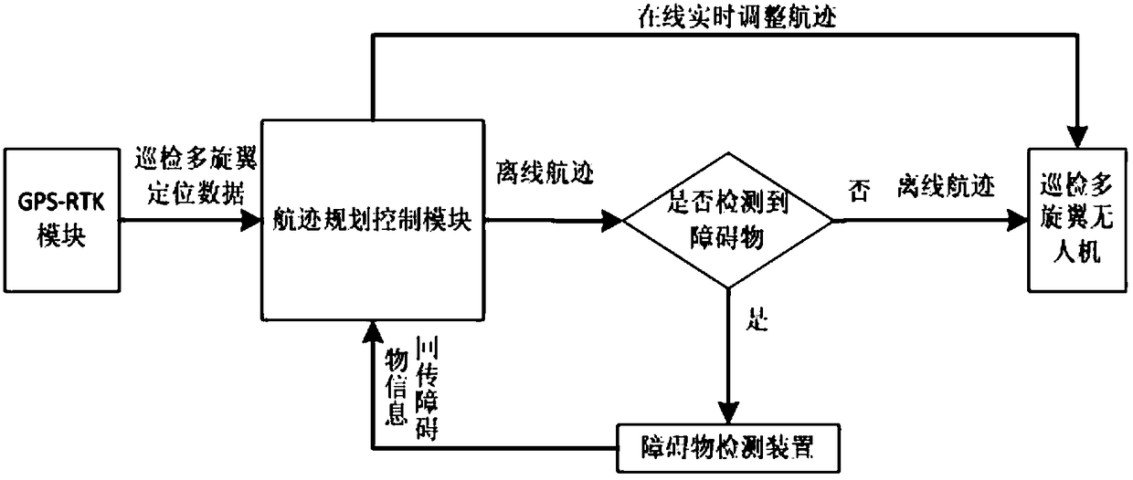
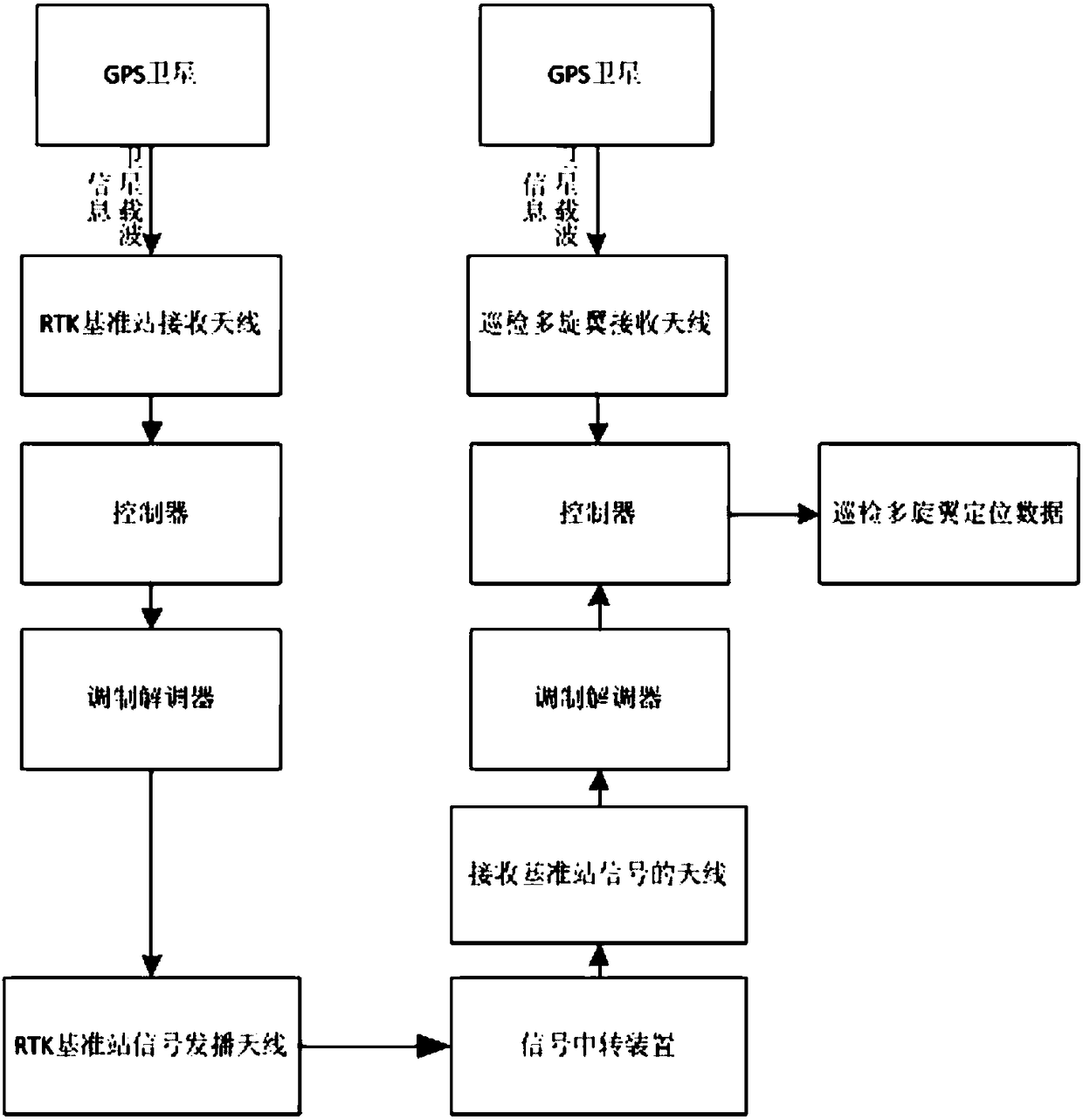
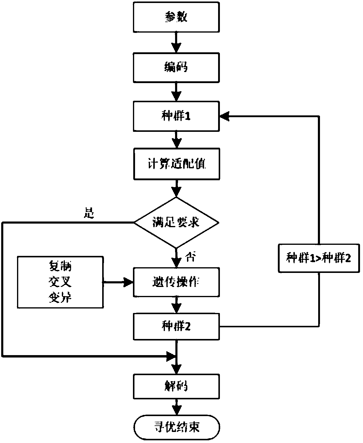
[0045] Example: such as Figure 1-Figure 3 As shown, a multi-rotor trajectory planning system for transmission line inspection, including GPS-RTK module, obstacle detection module, inspection multi-rotor UAV and trajectory planning control module, GPS-RTK module includes differential GPS The positioning system and RTK base station, the differential GPS positioning system uses two GPS receivers, which are used as the base station and the mobile station of the UAV respectively. The base station is installed on the field, and the mobile station is installed on the UAV. The GPS-RTK module is used to obtain To inspect the position of the UAV, the trajectory planning control module obtains the UAV position of the GPS-RTK module and the obstacle information detected by the obstacle detection module, and combines the geographic information to use the offline trajectory planning module and online adjustment trajectory The planning module performs offline track planning and online track...


PUM


Abstract

The invention discloses a multi-rotor flight-path planning system and method orienting to inspection of power transmission lines. The multi-rotor flight-path planning system comprises a GPS-RTK (Global Positioning System-Real Time Kinematic) module, an obstacle detecting module, a multi-rotor unmanned aerial vehicle and a flight-path planning control module, wherein the GPS-RTK module comprises adifferential GPS positioning system and an RTK base station; the differential GPS positioning system adopts two GPS receivers which are respectively used as a reference station and a mobile station ofthe unmanned aerial vehicle; the reference station is arranged on a site, the mobile station is arranged on the unmanned aerial vehicle; the flight-path planning control module acquires the positionof the unmanned aerial vehicle of the GPS-RTK module and obstacle information detected by the obstacle detecting module and carries out offline flight-path planning and online flight-path planning onthe multi-rotor unmanned aerial vehicle by combination with geological information. The multi-rotor flight-path planning system and method disclosed by the invention has the beneficial effects that the preset flight-path flying and online real-time adjustment of the flight-path flying of the unmanned aerial vehicle can be realized; in the process of in-advance automatic generation of offline reference flight path and inspection, the coordinates of the aerial vehicles are positioned according to the high-accuracy RTK, and by combination with the obstacle detection module, the inspection flightpath can be adjusted online, so that the collision of the unmanned aerial vehicles can be avoided.

Description

technical field [0001] The invention relates to a multi-rotor track planning system and method for power transmission line inspection, and belongs to the technical field of multi-rotor unmanned aerial vehicle track planning for power transmission line inspection. Background technique [0002] In recent years, since drones are easy to carry and control, transmission lines have begun to use multi-rotor drones for inspection, which can replace people climbing mountains and towers to a certain extent, with outstanding features such as maneuverability, flexibility, speed, efficiency, and safety. Gradually become an effective supplement to manned helicopters and manual inspections. However, the current multi-rotor drone inspection system has problems such as poor professional pertinence, complicated patrol track planning and control tasks, and high technical and application requirements for on-site operators. Encountered obstacles in the vehicle and lost control, resulting in los...

Claims


Application Information

Patent Timeline
Patent Type & Authority Applications(China)
IPC IPC(8): G01C21/20G01S19/45G01S19/41G05D1/10
CPCG01C21/20G01S19/41G01S19/45G05D1/101
Inventor 张伟刘锐许良柱杨磊虢韬彭赤陈凤翔周小红石书山陈科羽陈海华方广东
Owner GUIZHOU POWER GRID CO LTD
Why Eureka
Try Eureka