Geologic hazard monitoring early-warning system based on image recognition and early-warning method

A technology for geological disasters, monitoring and early warning, applied in character and pattern recognition, alarms, instruments, etc., can solve problems such as low accuracy and real-time performance of disaster monitoring, missing, data errors, etc., to achieve a wide range of applications and improve accuracy. , the effect of strong practicality

Active Publication Date: 2018-08-17
BEIJING INST OF AEROSPACE CONTROL DEVICES
View PDF5 Cites 13 Cited by
  • Summary
  • Abstract
  • Description
  • Claims
  • Application Information

AI Technical Summary

Problems solved by technology

There is no early warning, forecasting and monitoring system based on the combination of big data computing analysis and image recognition
And a single data analysis may cau...

Method used


Image

  • Geologic hazard monitoring early-warning system based on image recognition and early-warning method
  • Geologic hazard monitoring early-warning system based on image recognition and early-warning method

Examples


Embodiment Construction

[0041] Below in conjunction with accompanying drawing and specific embodiment the present invention is described in further detail:

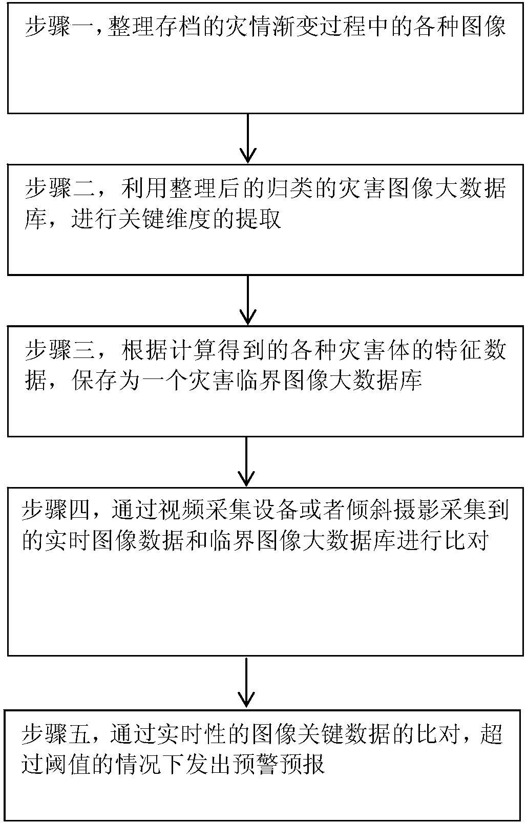
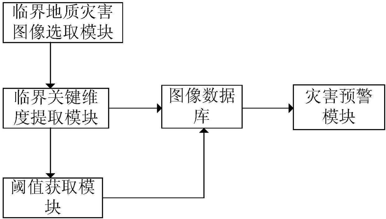
[0042] Such as figure 1 Shown is the flow chart of the geological disaster monitoring and early warning method based on image recognition in the present invention, and the early warning method of the present invention specifically includes the following steps:

[0043] Step (1), selecting a critical geological disaster image from geological disaster images occurring in different regions, where the critical geological disaster image is the geological disaster image at the time when the geological disaster occurs (the initial time of occurrence). Multiple critical geological hazard images of multiple disaster bodies can be selected in each region.

[0044] Specifically including: collating various images in the gradual process of the disaster situation archived by different regional analysis professionals. For example, the historical image informa...


PUM


Abstract

The invention relates to a geologic hazard monitoring early-warning system based on image recognition and an early-warning method thereof. The invention firstly provides the early-warning forecast monitoring system based on combination of big data calculation analysis and image recognition. Through selecting critical geologic hazard images in geologic hazard pictures which occur in different areas, a critical key dimension which influences motion of a hazard member is extracted, and furthermore a characteristic data threshold is obtained, thereby forming an image database. The image database is used as a reference for realizing effective hazard early-warning, thereby remarkably improving early-warning forecast accuracy, and overcoming problems such as data error and data loss caused by a traditional monitoring method. The image database formed in the method of the invention contain the critical image data of the hazard members in different areas, and geologic hazard monitoring early-warning can be performed on researching objects with different geologic structures in different areas. The geologic hazard monitoring early-warning system has advantages of wide application range and wide application prospect.

Description

technical field [0001] The invention relates to a geological disaster monitoring and early warning system and early warning method based on image recognition, in particular to a geological disaster monitoring and early warning system and early warning method based on big data and image recognition, which can be used for early warning and forecasting of geological disaster monitoring. Background technique [0002] At present, there are various monitoring and early warning methods for geological disasters, but they are basically based on data analysis collected by sensors, real-time monitoring after video image collection, or simple image recognition and judgment of two-dimensional and three-dimensional images collected by drones. There is no early warning, forecasting and monitoring system based on the combination of big data computing analysis and image recognition. And a single data analysis may cause data errors and missing data due to communication line problems, signal p...

Claims


Application Information

Patent Timeline
IPC IPC(8): G08B21/10G06K9/00
CPCG08B21/10G06V20/47
Inventor 蔡立明胡常青杨勇宋海滨李清洲张书翔董乾宜陈魁杨鹏周怡
Owner BEIJING INST OF AEROSPACE CONTROL DEVICES
Why Eureka
Try Eureka