Method for extracting lake and reservoir water level based on screened satellite altimetry data

A technology for satellite altimetry and data extraction, applied in satellite radio beacon positioning systems, measurement devices, surveying and navigation, etc. Data noise quality is not stable and other problems, to achieve the effect of strong applicability, reducing interference, and improving usability

Inactive Publication Date: 2018-08-24
CHINA INST OF WATER RESOURCES & HYDROPOWER RES
View PDF5 Cites 13 Cited by
  • Summary
  • Abstract
  • Description
  • Claims
  • Application Information

AI Technical Summary

Problems solved by technology

It has a good effect on lakes and reservoirs with stable and good data quality in each period, but this method is no longer applicable to lakes and reservoirs with relatively poor data quality or fluctuating data quality in a water level change cycle
The invention patent "A high-precision water surface elevation extraction algorithm" with the application number "201710617728.2" proposes the method of "if most of the elevation values ​​along the track are within the elevation interval of 1m, remove the excess part" to remove abnormal data, but in the inland lake area, due to The water surface is small or the terrain around the water body is complex, often more than half of the outliers in the first-phase data, it is difficult to find most of the consistent data, and the elevation interval of 1m is a very large height difference for inland lakes and reservoirs. The data for is still not guaranteed to be valid
The existence of data noise and the instability of quality have brought great difficulties to the large-scale promotion and operational operation of satellite altimetry technology

Method used


Image

  • Method for extracting lake and reservoir water level based on screened satellite altimetry data
  • Method for extracting lake and reservoir water level based on screened satellite altimetry data
  • Method for extracting lake and reservoir water level based on screened satellite altimetry data

Examples


Embodiment Construction

[0042] In order to make the object, technical solution and advantages of the present invention clearer, the present invention will be described in further detail below with reference to the accompanying drawings and examples.

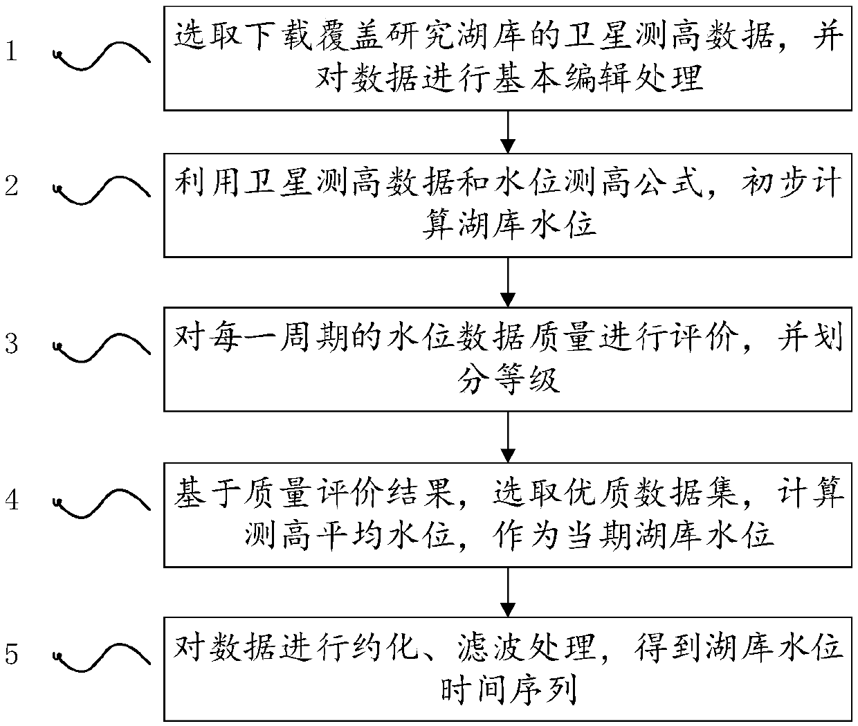
[0043] A method for extracting lake and reservoir water levels based on satellite altimetry data, comprising the following steps:

[0044]Step 1. Select the satellite altimetry data covering the research lake reservoir according to the satellite ground track, and perform basic editing and processing on the data;

[0045] Step 2. Substitute the processed data into the altimetry formula of the lake and reservoir, determine various correction parameters, and preliminarily calculate the water level of the lake and reservoir;

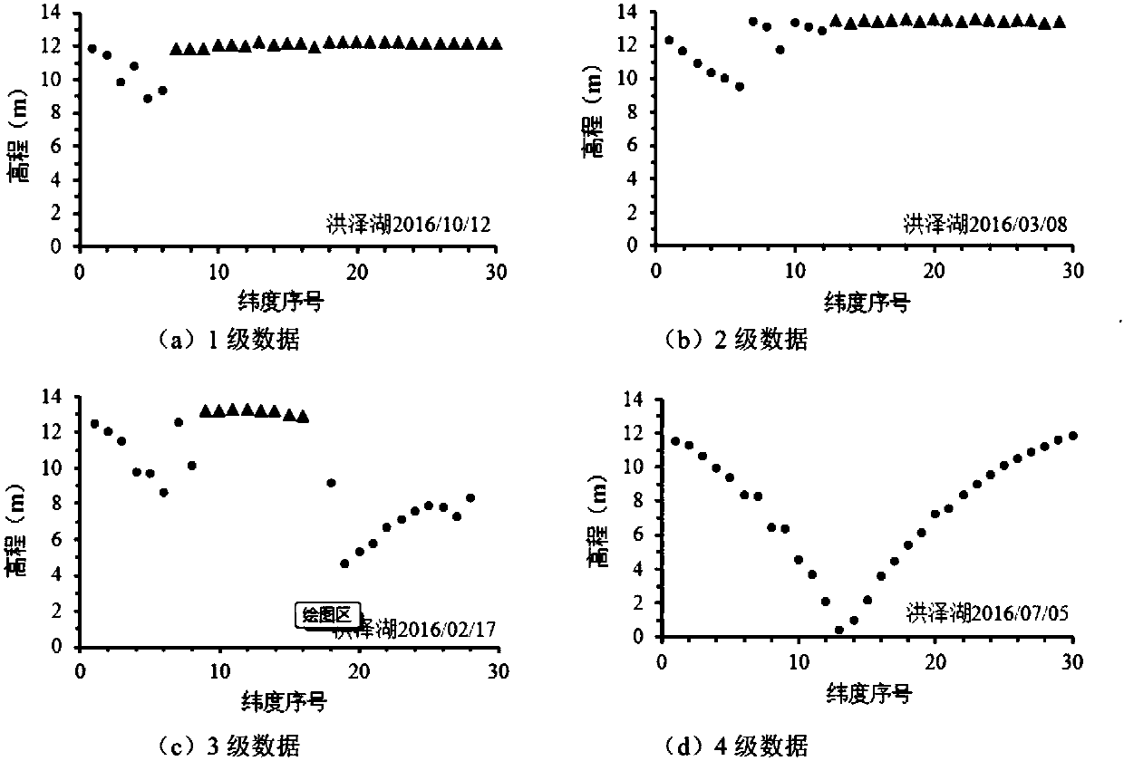
[0046] Step 3. Evaluate the data quality of each period, and divide the data into 4 quality levels;

[0047] Step 4. Screen out abnormal data based on the quality evaluation results, retain high-quality data, and calculate the averag...


PUM


Abstract

The invention discloses a method for extracting the lake and reservoir water level based on screened satellite altimetry data. The method includes the steps that satellite altimetry data is selected and downloaded, and basic editing processing is conducted on the satellite altimetry data; the lake and reservoir water level is preliminarily calculated with the satellite altimetry data and a water level altimetry formula; quality evaluation and quality grading are conducted on the satellite altimetry data according to the preliminarily calculated water level; abnormal data is screened out basedon the quality evaluation result, a high-quality data set is retained, and the altimetry mean water level is calculated to serve as the current lake and reservoir water level; finally, water level data of different periods is reduced to the same reference point, filtering processing is conducted in the whole time series, and gross errors are removed to obtain a relatively consistent lake and reservoir water level time series. The method can effectively eliminate interference caused by satellite altimetry data noise and improve the availability of satellite altimetry data and the precision of lake and reservoir water level monitoring.

Description

technical field [0001] The invention relates to the technical field of remote sensing monitoring of water resources, in particular to a method for extracting lake water levels based on selected satellite altimetry data. Background technique [0002] Obtaining the water level changes of lakes and reservoirs in time is one of the important contents in water resources monitoring. In the past, ground fixed-point (hydrological station) observations were mainly used to monitor water level changes. The ground monitoring method requires a large amount of infrastructure, which consumes a lot of manpower and material resources. It is impossible to deploy large-scale points in remote areas, and the daily monitoring effect will also be affected by ground stations. Monitor the impact of reporting frequency. In order to meet the needs of refined management of water resources, it is urgent to expand the scope of water resources monitoring and improve the monitoring accuracy, but ground mo...

Claims


Application Information

Patent Timeline
Patent Type & Authority Applications(China)
IPC IPC(8): G01F23/284G01S19/14G01C5/00
CPCG01C5/00G01F23/284G01S19/14
Inventor 文京川赵红莉蒋云钟郝震段浩陈德清纪刚易珍言黄艳艳王伶俐
Owner CHINA INST OF WATER RESOURCES & HYDROPOWER RES
Why Eureka
Try Eureka