Forest fire recognition method based on wind cloud weather satellite

A meteorological satellite and identification method technology, applied in the field of forest fire identification, can solve problems such as clutter interference, false fire point misjudgment and false alarm, etc., and achieve the effect of high time frequency, wide range and high accuracy

Active Publication Date: 2018-09-21
CENTRAL SOUTH UNIVERSITY OF FORESTRY AND TECHNOLOGY
View PDF8 Cites 10 Cited by
  • Summary
  • Abstract
  • Description
  • Claims
  • Application Information

AI Technical Summary

Problems solved by technology

[0004] However, these methods need to be improved in terms of technical accuracy and real-time performance. Today, when remote sensing technology is applied to forest fire prevention, it often occurs that false fire points are misjudged and misreported due to cloud reflections, solar flares, and clutter interference.

Method used


Image

  • Forest fire recognition method based on wind cloud weather satellite
  • Forest fire recognition method based on wind cloud weather satellite
  • Forest fire recognition method based on wind cloud weather satellite

Examples


Embodiment Construction

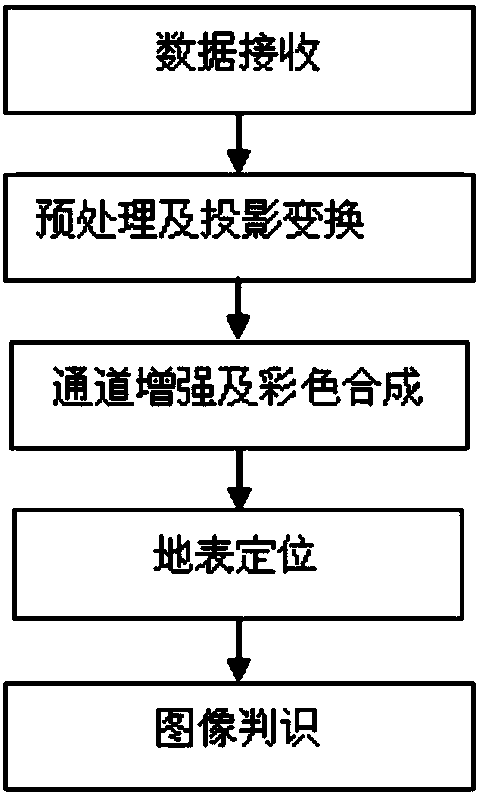
[0041] Such as figure 1 As shown, it is the process of generating forest fire images, which includes data receiving, preprocessing and projection transformation, channel enhancement and color synthesis, surface positioning, and image recognition processes.

[0042] Satellite forest fire monitoring uses satellites as space platforms to transmit, receive, interpret and monitor forest fires and monitor their behavior through the transmission, reception, interpretation and monitoring of sensor data. Since any object above the absolute temperature radiates radiant energy in the form of electromagnetic waves, the monitoring of forest fires by satellites is to use the high-resolution radiometers mounted on satellites to scan the surface of the earth from hundreds of kilometers through the atmospheric window. Detects the thermal radiation energy emitted by objects on the ground to identify forest fires.

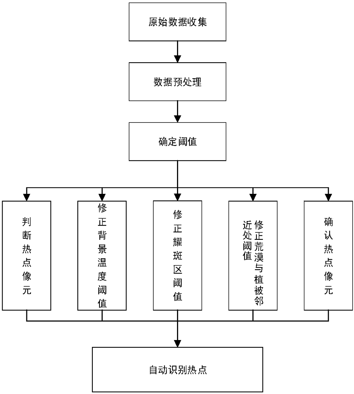
[0043] The satellite forest fire monitoring system receives the satellite detec...


PUM


Abstract

The invention relates to a forest fire recognition method based on a wind cloud weather satellite. The forest fire recognition method based on the wind cloud weather satellite comprises the followingsteps: receiving and acquiring original data; preprocessing the original data; and determining the threshold value for performing forest fire recognition and automatically performing forest fire hot spot recognition, wherein the determined threshold value comprises a judgment hot spot unit, a correction background temperature threshold value, a correction solar flare threshold value and a correction desert and vegetation nearby threshold value, so that the hot spot unit is confirmed. According to the method and through weather satellite monitoring, fire disaster which occurs early can be discovered in time and extinguished as soon as possible, the trend and extension situation can be monitored, and a serious forest fiber disaster is tracked and monitored.

Description

technical field [0001] The invention relates to a forest fire identification method based on Fengyun meteorological satellite data. Background technique [0002] Nowadays, the rapid development of RS, GIS, and GPS (3S) has not only made great progress in remote sensing monitoring of forest fires, but the continuous improvement of technology has also made the system tend to develop in the direction of automation and intelligence. The NOAA satellites of the National Oceanic and Atmospheric Administration of the United States and the Geostationary Operational Environmental Satellite (GOES) satellites are the first platforms used in forest fire monitoring, which have played a huge role in fire monitoring. NOAA / AVHRR data is extremely useful in detecting fires worldwide. 1981 used a theoretical model of sub-pixel temperature, which was eliminated by AVHRR data, and laid a theoretical foundation for further research. On this basis, AVHRR data is used for in-depth research on dif...

Claims


Application Information

Patent Timeline
IPC IPC(8): G08B17/12G06K9/00
CPCG08B17/125G06V20/13
Inventor 张贵谭三清胡杨柳王赛专
Owner CENTRAL SOUTH UNIVERSITY OF FORESTRY AND TECHNOLOGY
Why Eureka
Try Eureka