Forest Fire Identification Method Based on Fengyun Meteorological Satellite Data
A meteorological satellite and identification method technology, applied in the field of forest fire identification, can solve the problems of false fire point misjudgment, misreporting, clutter interference, etc., and achieve the effect of wide range, high time frequency and high accuracy
- Summary
- Abstract
- Description
- Claims
- Application Information
AI Technical Summary
Problems solved by technology
Method used
Image
Examples
Embodiment Construction
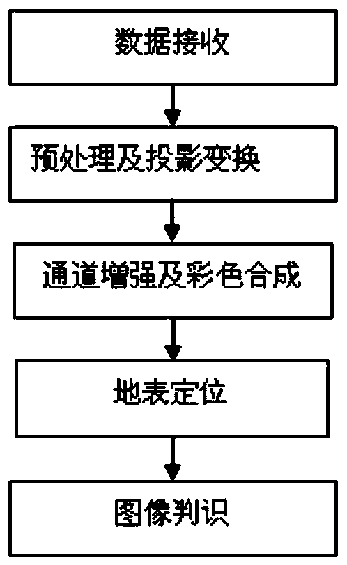
[0041] Such as figure 1 As shown, it is the process of generating forest fire images, which includes data receiving, preprocessing and projection transformation, channel enhancement and color synthesis, surface positioning, and image recognition processes.
[0042] Satellite forest fire monitoring uses satellites as space platforms to transmit, receive, interpret and monitor forest fires and monitor their behavior through the transmission, reception, interpretation and monitoring of sensor data. Since any object above the absolute temperature radiates radiant energy in the form of electromagnetic waves, the monitoring of forest fires by satellites is to use the high-resolution radiometers mounted on satellites to scan the surface of the earth from hundreds of kilometers through the atmospheric window. Detects the thermal radiation energy emitted by objects on the ground to identify forest fires.
[0043] The satellite forest fire monitoring system receives the satellite detec...
PUM
 Abstract
Description
Claims
Application Information
 - R&D
- Intellectual Property
- Life Sciences
- Materials
- Tech Scout
- Unparalleled Data Quality
- Higher Quality Content
- 60% Fewer Hallucinations
Browse by: Latest US Patents, China's latest patents, Technical Efficacy Thesaurus, Application Domain, Technology Topic, Popular Technical Reports.
© 2025 PatSnap. All rights reserved.Legal|Privacy policy|Modern Slavery Act Transparency Statement|Sitemap|About US| Contact US: help@patsnap.com


