
Residential area extraction method

An extraction method and technology of residents, applied in the direction of photo interpretation, etc., can solve the problems of high work intensity, low precision, and low efficiency, and achieve the effect of high work intensity and accurate extraction

Active Publication Date: 2018-09-28
INST OF GEOCHEM CHINESE ACADEMY OF SCI
View PDF1 Cites 7 Cited by
  • Summary
  • Abstract
  • Description
  • Claims
  • Application Information

AI Technical Summary

Problems solved by technology

[0004] The technical problem to be solved by the present invention is to provide a method for extracting residential areas to solve the technical problems of high work intensity, low precision and low efficiency in the prior art of residential area extraction.

Method used


Image

  • Residential area extraction method
  • Residential area extraction method

Examples


Embodiment Construction

[0036] The invention provides a method for extracting residential areas, comprising the following steps:

[0037] First, data acquisition. The data required for the extraction of residential areas are the Landsat 8 OLI sensor remote sensing images and the administrative boundary data of the research area. These data can be downloaded from the Geospatial Data Cloud website (URL: http: / / www.gscloud.cn / ).

[0038] Second, remote sensing image data preprocessing. Data preprocessing mainly includes radiometric calibration, atmospheric correction, image fusion, and image cropping (image cropping refers to using the boundary of the research area to clip the remote sensing image to obtain the remote sensing image map of the research area), so as to increase the resolution of the image and provide Lay the foundation for subsequent analysis and research, which is implemented in ENVI software.

[0039] Third, calculate the surface albedo (Albedo) of the preprocessed remote sensing ima...


PUM


Abstract

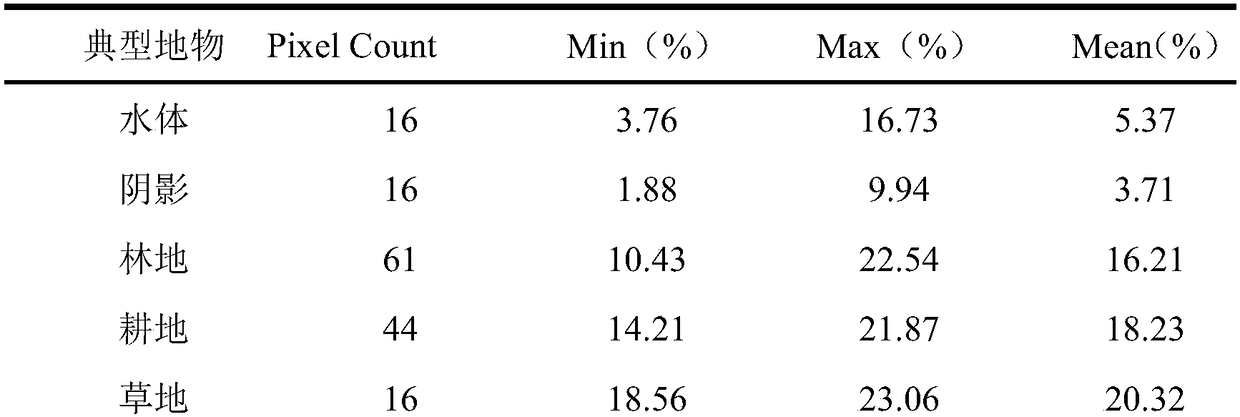
The invention discloses a residential area extraction method. The method comprises the following steps: collecting the Landsat 8 OLI sensor remote sensing image and the administrative boundary data ofa research area; preprocessing the remote sensing image; calculating the surface albedo of the preprocessed remote sensing image; extracting water bodies and shadows according to the surface albedo;extracting shadows from the obtained water and shadow map layer by using a single-band threshold technology to distinguish the water bodies and the shadows; performing closed operation filtering processing on the obtained water extraction result; calculating the normalized vegetation index of the preprocessed remote sensing image, determining a threshold, and cutting off the water body, shadow andvegetation maps extracted in above steps from the original boundary map layer of the research area to obtain a remaining map layer which is the residential area and road distribution map of the research area; and calculating the shape index of the residential area and the road distribution map, determining the threshold value of the shape index (I), and extracting roads and the residential area.The problems of large work intensity, low precision and low efficiency in existing residential area extraction are solved.

Description

technical field [0001] The invention belongs to the technology of extracting residential areas, in particular to a method for extracting residential areas. Background technique [0002] Residential places, also known as "residential places" or settlements, are the product of the interaction between man and nature, various forms of residential places where human beings gather and settle in order to meet the needs of production and life, and are a combination of natural landscapes, architectural landscapes and cultural landscapes. The body is the basic place of people's life and production. Accurate extraction of residential areas is the most basic source of geographic data for residential planning, development, and change monitoring. It has profound significance for the changes and impacts of residential areas, and is conducive to the realization of sustainable regional development. Town planning, land resource protection and other related research plays an important role. ...

Claims


Application Information

Patent Timeline
Patent Type & Authority Applications(China)
IPC IPC(8): G01C11/04
CPCG01C11/04
Inventor 白晓永杨钰杰李朝君肖建勇钱庆欢
Owner INST OF GEOCHEM CHINESE ACADEMY OF SCI
Learn More