A method for dynamic monitoring of urban traffic emission pollution based on taxi gps data

A GPS data and dynamic monitoring technology, which is applied in the traffic control system of road vehicles, traffic flow detection, traffic control system, etc., can solve the problem of low data accuracy, and achieve the effect of high accuracy and low cost

Active Publication Date: 2021-07-13
HARBIN INST OF TECH
View PDF8 Cites 0 Cited by
  • Summary
  • Abstract
  • Description
  • Claims
  • Application Information

AI Technical Summary

Problems solved by technology

[0005] In order to solve the problem of low accuracy of real-time monitoring data of traffic emission pollution in the prior art, the present invention provides a method for dynamically monitoring urban traffic emission pollution based on taxi GPS data

Method used


Image

  • A method for dynamic monitoring of urban traffic emission pollution based on taxi gps data
  • A method for dynamic monitoring of urban traffic emission pollution based on taxi gps data
  • A method for dynamic monitoring of urban traffic emission pollution based on taxi gps data

Examples


specific Embodiment approach 1

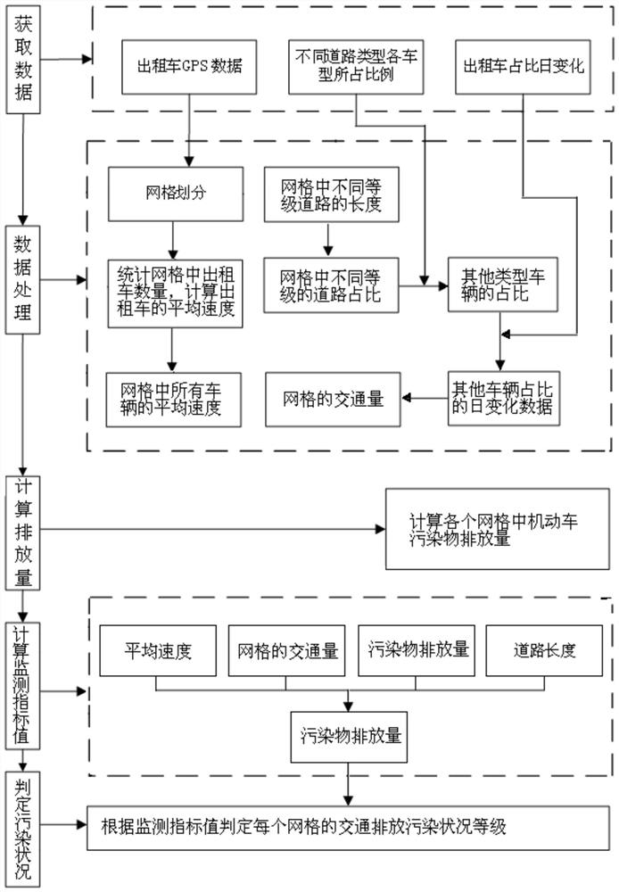
[0039] Specific implementation mode one: combine figure 1 The present embodiment is described, the method that the present embodiment provides based on the taxi GPS data dynamic monitoring urban traffic emission pollution situation, specifically comprises the following steps:

[0040] 1), collect taxi GPS data, the proportion of each vehicle type of different road types and the daily change of taxi proportion; Proportion;

[0041] Data collection is mainly to provide data basis for the calculation of monitoring factors. Among them, taxi GPS data is mainly collected by relevant departments; GPS data includes: vehicle ID, latitude and longitude, sampling time, instantaneous speed, GPSID and driving direction; Rely on traffic survey data collection, but need to be updated from time to time to ensure the accuracy of the data. The data collected by the traffic survey needs to cover four types of roads: expressway, main road, secondary road and branch road, and the vehicle types ...

specific Embodiment approach 2

[0052] Specific embodiment two: the difference between this embodiment and specific embodiment one is that the specific steps of motor vehicle pollutant emissions in the calculation grid described in step 4) are:

[0053] Step 41) Calculate the emissions of n types of pollutants in the grid j, the specific steps are as follows:

[0054]

[0055] Among them, E j,n Indicates the emission of n types of pollutants in grid j in T time interval, the unit is grams; E j,i,n Indicates the emission of n types of pollutants emitted by i-type motor vehicles in grid j in the time interval T, the unit is grams; i∈{1,...,I}, I represents the total number of motor vehicle types counted, n ∈{1,…,N}, where N represents the total number of pollutant types calculated; EF i,n Indicates the amount of n-type pollutants emitted by i-type motor vehicles per unit distance, in grams / km; P j,i Indicates the number of motor vehicles of type i in grid j, unit is vehicle; VKT j,i Indicates the mileag...

specific Embodiment approach 3

[0062] Specific embodiment three: the difference between this embodiment and specific embodiment two is that the discharge amount of n type pollutants discharged by i type motor vehicle traveling unit distance (that is, i type motor vehicle n type pollutant emission coefficient) EF i,n The specific calculation steps are as follows:

[0063]

[0064] Among them, BEF i,n Indicates the comprehensive benchmark emission coefficient of n-type pollutants of i-type motor vehicles, Indicates the environmental correction factor (where grid j is located), γ indicates the average speed correction factor, λ i Denotes the degradation correction factor of type i motor vehicle, θ i Indicates the correction factor for other service conditions (such as load factor, oil quality, etc.) of the type of motor vehicle.

[0065] Other steps and parameters are the same as in the second embodiment.


PUM


Abstract

The invention provides a method for dynamically monitoring urban traffic discharge pollution conditions based on taxi GPS data, and belongs to the technical field of atmospheric environment monitoring. The present invention firstly collects the taxi GPS data, the proportion of each vehicle type of different road types and the daily change of the taxi proportion; divides the collected GPS data into grids based on GIS, and then calculates the traffic volume and average speed of each grid , pollutant emissions; select the traffic volume, average speed, pollutant discharge and road length of each grid as monitoring factors, and calculate the monitoring index value of each grid according to the weight of each monitoring factor, and finally according to the monitoring index value Determine the traffic emission pollution status level of each grid. The invention solves the problem of low accuracy of real-time monitoring data of traffic emission pollution status in the prior art. The invention can be used for monitoring the urban traffic emission pollution status.

Description

technical field [0001] The invention belongs to the technical field of atmospheric environment monitoring, and in particular relates to a method for dynamically monitoring urban traffic discharge pollution conditions. Background technique [0002] With the rapid development of social economy and the rapid growth of the number of motor vehicles, motor vehicle exhaust pollution in urban areas has increasingly become one of the main sources of air pollution in cities. The increasing traffic emission pollution year by year not only destroys the urban environment, but also poses a serious threat to the health of residents. Therefore, it is imperative to realize the monitoring of urban traffic emission pollution and to take effective measures to manage and control motor vehicle exhaust pollution. [0003] At present, many cities in China use the annual average mileage method to estimate the total amount of motor vehicle exhaust emissions, and have established their own inventorie...

Claims


Application Information

Patent Timeline
Patent Type & Authority Patents(China)
IPC IPC(8): G08G1/01
CPCG08G1/0112G08G1/0137
Inventor 王健蔡海明胡晓伟左文泽孙云瑞刘文佳
Owner HARBIN INST OF TECH
Why Eureka
Try Eureka