ArcGIS based batch matching road attributes method

A road attribute and batch technology, applied in special data processing applications, instruments, electrical digital data processing, etc., to achieve high efficiency, relieve cumbersome operations, and good user experience effects

Active Publication Date: 2018-11-09
CHANGAN UNIV
View PDF5 Cites 5 Cited by
  • Summary
  • Abstract
  • Description
  • Claims
  • Application Information

AI Technical Summary

Problems solved by technology

[0004] In order to solve the problem of non-equidistant batch-breaking matching attributes, the present invention proposes a method for batch-matching road attributes based on ArcGIS, and the method of the present invention can batch non-equidistantly interrupting and matching corresponding attribute data

Method used


Image

  • ArcGIS based batch matching road attributes method
  • ArcGIS based batch matching road attributes method
  • ArcGIS based batch matching road attributes method

Examples


Embodiment Construction

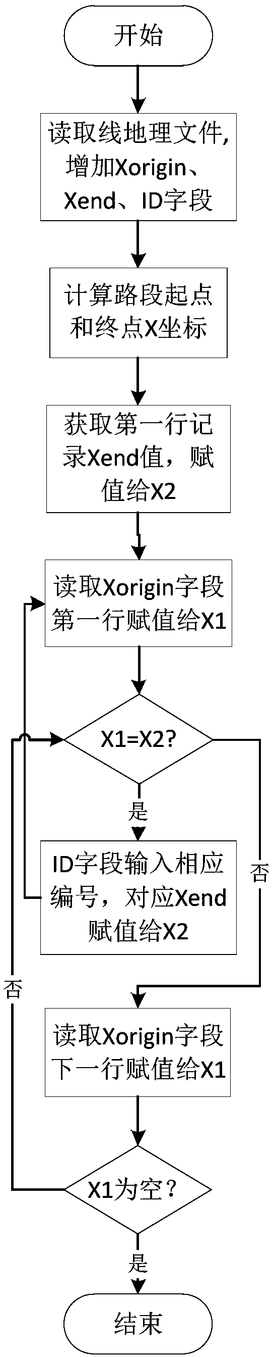
[0038] The present invention will be further described below in conjunction with the accompanying drawings and project examples for implementation reference. The technical scheme of the present invention can use ArcGIS software to realize the automatic operation process, obtain road detection data and road line geographic files before proceeding, and calculate and match road attribute data through the road detection data and road line geographic files, wherein the road detection data includes road sections Length and evaluation indicators, etc.

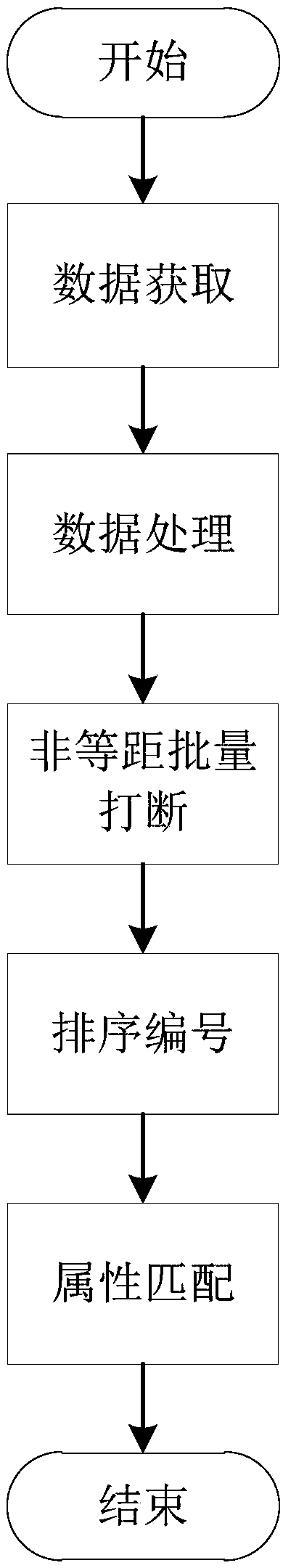
[0039] refer to image 3 , the flow process of the embodiment of the present invention is as follows:

[0040] Step 1, calculate the road length through the road detection section length data; then calculate the error between the GIS road length corresponding to the line geographic file and the road length calculated by the detection data; and then divide the error equally into each section of the road detection data, Obtain the det...


PUM


Abstract

The invention discloses an ArcGIS based batch matching road attributes method. The method includes obtaining an error between road lengths by calculating through GIS road lengths corresponding to a line geographic file and detection data; equally dividing the error into each segment of the road detection data to obtain detection length data; performing batch interruption on the GIS road network ofthe line geographic file according to the detection length data to obtain interrupted line elements; performing ordering and numbering on the line elements according to line directions, and storing the ordering and numbering on newly built ID fields; and adding the ID fields into matching road attribute data, and connecting the line elements with the attribute data according to the ID fields so that attribute matching can be realized. The method is an ArcGIS processing method which can perform line batch interruption to match road attributes, and a novel technical route can be provided for road attribute matching. The method can automatically interrupt matching road attributes and relieve the cumbersome operation of traditional manual interrupt matching, and therefore, high efficiency canbe realized, and good user experience effects can be achieved.

Description

technical field [0001] The invention belongs to the field of traffic planning, in particular to a method for matching road attributes in batches based on ArcGIS. Background technique [0002] ArcGIS is a full series of GIS products representing the highest technical level of GIS successfully launched by the American ESRI company after fully integrating GIS (Geographic Information System) with database, network technology and other mainstream computer technologies. ArcGIS is a comprehensive, scalable GIS platform that provides a complete solution for users to build a complete GIS system. [0003] With the development of geographic information technology, GIS technology is widely used in various fields. In traffic planning, the road network system established by ArcGIS needs to be interrupted in non-equidistant batches according to project requirements, and match corresponding attributes to each road section. When there are many road sections and a large amount of attribute ...

Claims


Application Information

Patent Timeline
Patent Type & Authority Applications(China)
IPC IPC(8): G06F17/30
Inventor 王元庆刘晓杰孙亚滨
Owner CHANGAN UNIV
Why Eureka
Try Eureka