GNSS-RTK-based positioning method

A positioning method and variance technology, applied in the field of satellite navigation and positioning, can solve the problems of poor accuracy and reliability

Inactive Publication Date: 2018-11-20
ZHEJIANG YAT ELECTRICAL APPLIANCE CO LTD +1
View PDF7 Cites 21 Cited by
  • Summary
  • Abstract
  • Description
  • Claims
  • Application Information

AI Technical Summary

Problems solved by technology

With the continuous increase of people's demand for location information, the traditional high-cost and high-precision positioning mode can no longer me

Method used


Image

  • GNSS-RTK-based positioning method
  • GNSS-RTK-based positioning method
  • GNSS-RTK-based positioning method

Examples


Embodiment Construction

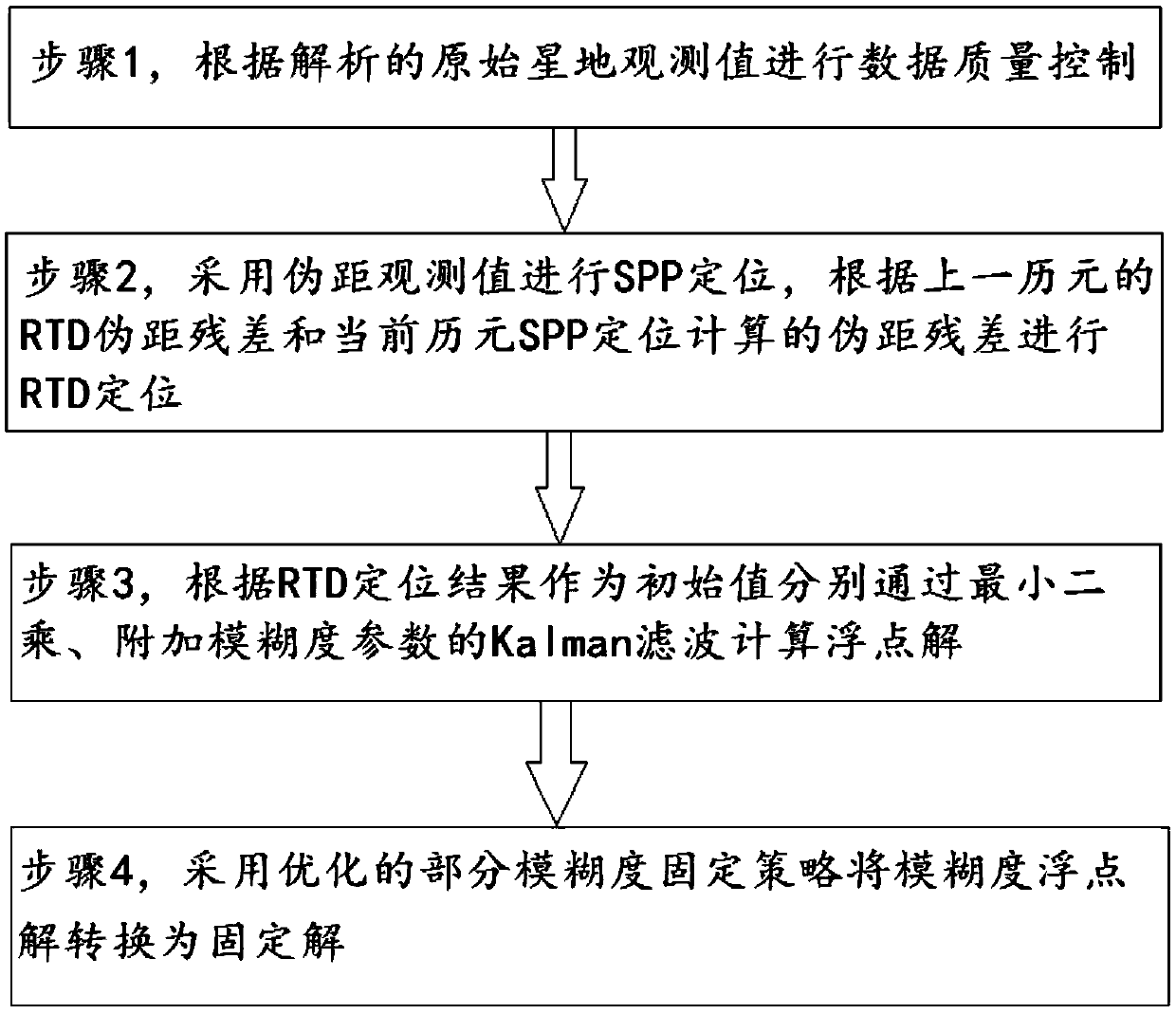
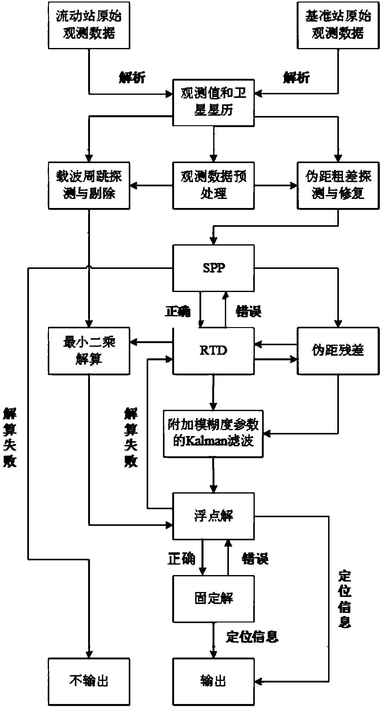
[0073] Below in conjunction with accompanying drawing, technical solution of the present invention is described further, but the present invention is not limited to these embodiments.

[0074] A positioning method based on GNSS-RTK, the main ideas of which include:

[0075] (1) Data preprocessing and quality control. Select reliable satellite observations, discover and repair pseudo-range gross errors, detect and eliminate carrier cycle slips, provide reliable pseudo-range and carrier observations, ensure continuity of ambiguity, and reduce or prevent fixed unlocking;

[0076] (2) The random model is updated in real time. The RTD (Real-time Pseudorange Relative Positioning) random model is determined according to the SPP (Pseudorange Single Point Positioning) residual and the post-test residual of the previous epoch, and the floating-point double-difference pseudorange random model is determined according to the RTD residual, ensuring The accuracy of the random model improve...


PUM


Abstract

The invention belongs to the satellite navigation positioning field and relates to a GNSS-RTK-based positioning method. The GNSS-RTK-based positioning method comprises steps that S1, data quality control is performed according to analyzed original satellite-ground observation values; S2, a pseudorange observation value is utilized for SPP positioning, and RTD positioning is performed according toan RTD pseudorange residual of a previous epoch and a pseudorange residual of a current epoch SPP obtained through positioning calculation; S3, the RTD positioning result is taken as an initial value,through the least squares method and Kalman filtering of additional ambiguity parameters, the floating point solution is calculated; and S4, the optimized partial ambiguity fixed strategy is utilizedto convert the ambiguity floating point solution into the fixed solution. The method is advantaged in that the ambiguity can be quickly fixed, solution performance in the complex environments is relatively high, the accurate continuous high-precision position information in the complex environments is provided, the solution information is fully utilized, quick ambiguity fixing is realized, and the high-precision high-reliability position and speed information is provided.

Description

technical field [0001] The invention belongs to the field of satellite navigation and positioning, and relates to a positioning method based on GNSS-RTK. Background technique [0002] GNSS: Global Navigation Satellite System (Global Navigation Satellite System), also known as Global Navigation Satellite System, is a space-based system that can provide users with all-weather 3-dimensional coordinates, speed and time information at any point on the earth's surface or in near-earth space. Radio Navigation and Positioning System. RTK (Real-time kinematic, real-time dynamic) carrier phase difference technology is a difference method for real-time processing of carrier phase observations of two measuring stations, and sends the carrier phase collected by the base station to the user receiver for difference calculation and coordinate calculation. With the continuous increase of people's demand for location information, the traditional high-cost and high-precision positioning mode ...

Claims


Application Information

Patent Timeline
IPC IPC(8): G01S19/41G01S19/44
CPCG01S19/41G01S19/44
Inventor 陈勇龚建飞陈凤梧张哲扈璇璇李兴国赵士栋王烁
Owner ZHEJIANG YAT ELECTRICAL APPLIANCE CO LTD
Why Eureka
Try Eureka