Dynamic path planning method for AUV (Autonomous Underwater Vehicle) submarine topography matching

A terrain matching and dynamic path technology, applied in road network navigators, data processing applications, forecasting and other directions, can solve the problems of modifying the path, not considering the terrain navigation ability, and not considering the poor terrain navigation ability of the matching area.

Active Publication Date: 2018-11-23
HARBIN ENG UNIV
View PDF4 Cites 24 Cited by
  • Summary
  • Abstract
  • Description
  • Claims
  • Application Information

AI Technical Summary

Problems solved by technology

[0006] Publication date is October 10, 2012, publication number is CN102722749A, and the patent application title is "A method for adaptive three-dimensional space path planning based on particle swarm algorithm". This method only plans the traditional obstacle avoidance path, and does not Consider the navigation ability of the terrain, and cannot modify the path in real time considering the change of terrain information when the robot executes the path
[0007] The publication date is January 1, 2016, and the paper titled "Path Planning Method for AUV Underwater Terrain Matching Navigation", the paper proposes a fan-shaped search method for the adaptation area, based on the premise of the shortest distance, and does not consider the matching area The problem of poor terrain navigation ability, and when the robot executes the path, it cannot consider the change of terrain information and modify the path in real time

Method used


Image

  • Dynamic path planning method for AUV (Autonomous Underwater Vehicle) submarine topography matching
  • Dynamic path planning method for AUV (Autonomous Underwater Vehicle) submarine topography matching
  • Dynamic path planning method for AUV (Autonomous Underwater Vehicle) submarine topography matching

Examples


Embodiment 1

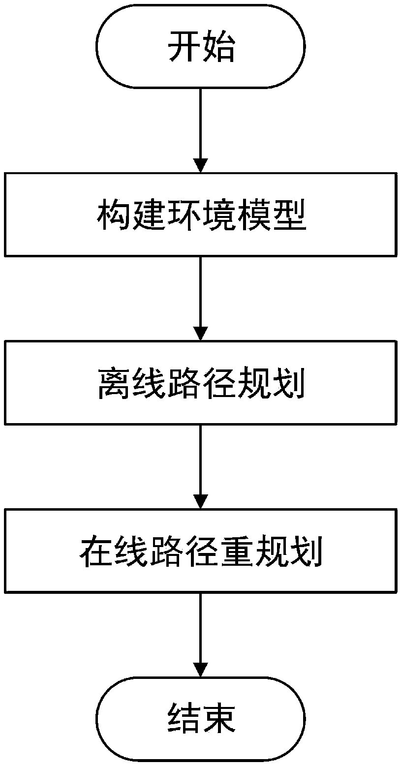
[0060] This paper deals with a dynamic path planning method, including environment modeling, offline path planning and online path replanning. Simulate the physical environment and navigation capabilities using obstacles, terrain information, and terrain source confidence. Offline path planning consists of four steps: generate random nodes, generate new nodes, select the best parent node and calculate path cost. Online path replanning consists of four steps: identifying changing terrain, finding local optimal nodes, local path planning, and refining the entire path. Finally, a seabed path with higher navigation accuracy and shorter distance is obtained.

[0061] Content of the present invention is realized like this: comprise the following steps:

[0062] 1. Construct the environmental model of the seabed. For the physical environment map of the seabed, it is gridded first, so as to become a grid map with height h(i,j) for point (i,j). Then, the navigation ability of each ...

Embodiment 2

[0107] figure 1 The system flow of the present invention has been expressed, and the specific implementation steps are as follows:

[0108] (1) According to the surveyed and mapped seabed terrain map, it is gridded, and the terrain features of each grid point are extracted for path planning and terrain matching.

[0109] (2) Before the AUV performs the task, the offline path planning algorithm is used for global path planning.

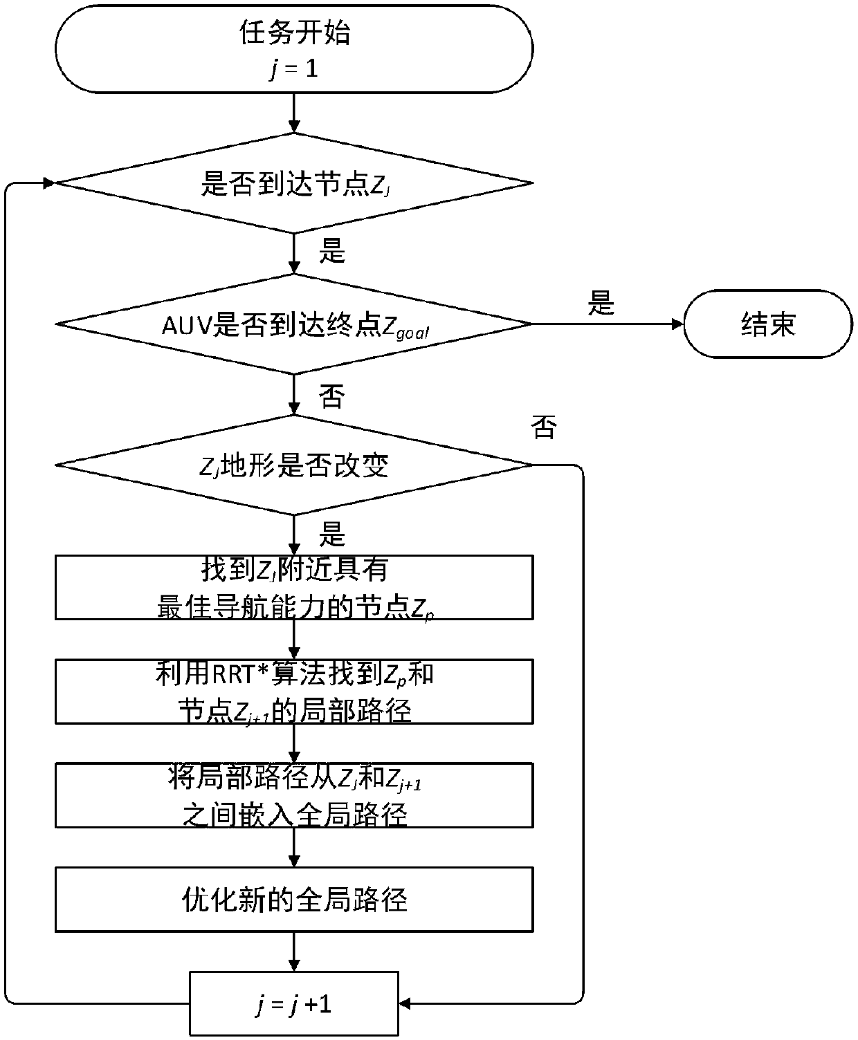
[0110] (3) After the AUV starts to execute the task, it uses the online path re-planning algorithm for real-time global path optimization to achieve navigation accuracy.

[0111] (4) After the AUV reaches the destination, the entire dynamic path planning method ends.

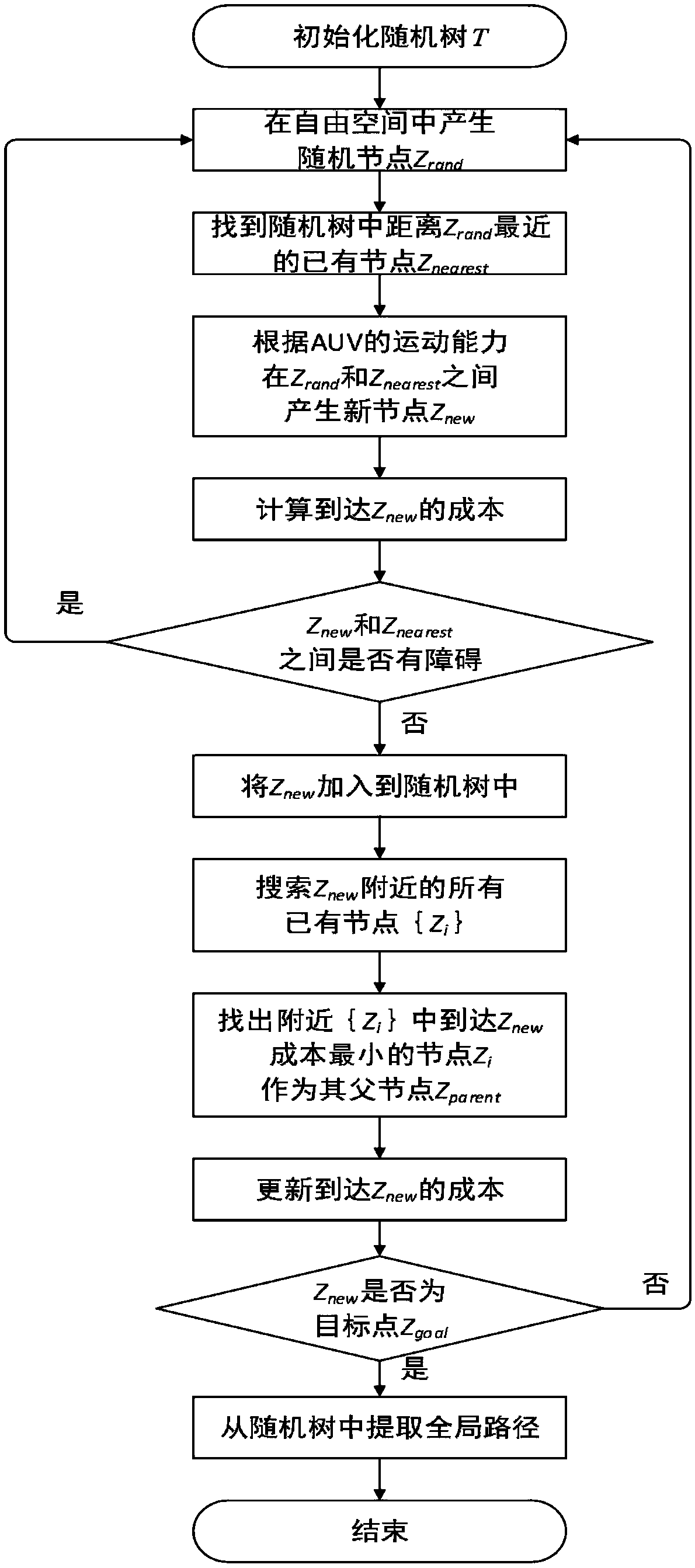
[0112] figure 2 It is a flow chart of the offline path planning algorithm of the present invention, and the specific implementation steps are as follows:

[0113] (1) Use the starting point z init Initialize the random tree T=(V,E), where V represents the nodes in the random tree a...


PUM


Abstract

The invention discloses a dynamic path planning method for AUV (Autonomous Underwater Vehicle) submarine topography matching, and belongs to the technical field of AUV navigation. The dynamic path planning method comprises environment modeling, offline path planning and online path re-planning. An environment model is constructed by topography information and topography source confidence, whereina topography characteristic is represented with a topography standard deviation. Offline path planning is based on a rapid search random tree algorithm, improves a new node and father node selection algorithm, and processes the topography information by roulette and a mahalanobis distance so as to avoid a low topography information region. When an AUV navigates along an offline path and detects changes of the topography information, online re-planning implements judgment on the topography changes by methods of judging the topography changes, searching a local navigation optimal node, re-optimizing a global path and the like, and ensures navigation accuracy. The dynamic path planning method is applicable to long-voyage high-accuracy AUV path planning, and particularly when the topography information is changed, by modifying the path in real time, navigation accuracy and a path distance are ensured.

Description

technical field [0001] The invention relates to the technical field of underwater vehicle navigation, in particular to a dynamic path planning method for AUV seabed terrain matching. Background technique [0002] With the development of integrated navigation, underwater vehicles generally use inertial navigation system (Inertial Navigation System, INS) when navigating on the seabed, because there is no GPS navigation, and are equipped with expensive auxiliary equipment, such as attitude and heading reference system or Doppler speed recorder. However, inertial navigation systems suffer from cumulative errors over time and are not suitable for long-range underwater navigation without the use of other precise methods of assisted positioning. As a geophysical navigation method, terrain-adaptive navigation (TAN) can provide accurate position estimation for AUV's long-range underwater operation, and its fusion with inertial navigation system can well eliminate its accumulated err...

Claims


Application Information

Patent Timeline
Patent Type & Authority Applications(China)
IPC IPC(8): G01C21/30G01C21/32G06Q10/04
CPCG01C21/30G01C21/32G06Q10/047
Inventor 李晔徐硕马腾丛正贡雨森王汝鹏
Owner HARBIN ENG UNIV
Why Eureka
Try Eureka