Spatio-temporal precision calibration method of multi-satellite remote sensing precipitation inversion in large-scale complex watersheds

A technology of satellite remote sensing and calibration method, which is applied to instruments, ICT adaptation, image data processing, etc., to achieve great scientific significance and improve accuracy

Active Publication Date: 2020-05-29
HOHAI UNIV
View PDF2 Cites 0 Cited by
  • Summary
  • Abstract
  • Description
  • Claims
  • Application Information

AI Technical Summary

Problems solved by technology

[0004] In order to solve the technical problems raised by the above-mentioned background technology, the present invention aims to provide a time-space accuracy calibration method for multi-satellite remote sensing precipitation inversion in large-scale complex watersheds

Method used


Image

  • Spatio-temporal precision calibration method of multi-satellite remote sensing precipitation inversion in large-scale complex watersheds
  • Spatio-temporal precision calibration method of multi-satellite remote sensing precipitation inversion in large-scale complex watersheds

Examples


Embodiment Construction

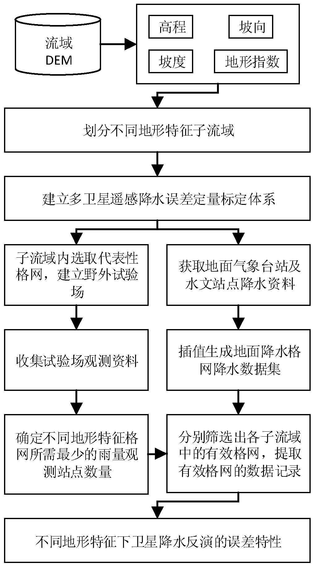
[0020] The technical solutions of the present invention will be described in detail below in conjunction with the accompanying drawings.

[0021] 1. Data preparation

[0022] The specific data include: (a) DEM data in the Laoha River Basin; (b) daily precipitation data of 53 national reference meteorological stations in the Laoha River Basin; (b) satellite precipitation retrieval data TMPA V7.

[0023] 2. The specific implementation process

[0024] (1) Based on the watershed DEM data, terrain information such as elevation (Elevation), slope (Slope), aspect (Aspect) and terrain index (TI) are extracted, and the large-scale complex watershed is divided into N topographically similar sub-basins. The process It can be expressed as:

[0025] {Basin 1 ,Basin 2 ,...,Basin N} = f(Elevation, Slope, Aspect, TI)

[0026] Select a single representative grid in N sub-basins with different topographical characteristics, and deploy appropriate amount of automatic rain gauges and artif...


PUM


Abstract

The invention discloses a space-time accuracy calibration method for multi-satellite remote sensing precipitation inversion in a large-scale complex watershed. The space-time accuracy calibration method comprises the steps of dividing the large-scale complex watershed into a plurality of sub-watersheds with similar topography, and respectively establishing field high-density test sites in single representative grids with different topographic characteristics; constructing a multi-satellite remote sensing precipitation inversion error quantitative calibration system; determining the minimum number of precipitation observation points required by the grids under different topographic characteristics; respectively screening out valid grids in all sub-watersheds according to the minimum precipitation observation station number requirements; and matching a ground precipitation grid data set with data records of satellite precipitation inversion in the valid grids, and further analyzing errorcharacteristics of satellite precipitation inversion under different topographic characteristics by applying an error calibration system. The space-time accuracy calibration method discloses an influence mechanism of complex terrain for the accuracy of a satellite precipitation inversion algorithm, provides suggestions for the development and improvement of the satellite precipitation inversion algorithm, and further improves the accuracy of satellite precipitation inversion in complex terrain.

Description

technical field [0001] The invention belongs to the field of watershed hydrometeorology, and in particular relates to a time-space precision calibration method for multi-satellite remote sensing precipitation inversion in large-scale complex watersheds. Background technique [0002] Precipitation is a key factor in the simulation and prediction of runoff change. Acquiring precipitation data with high temporal and spatial accuracy at low cost and quickly has always been a research hotspot in the field of hydrometeorology. Due to the complex physical process of precipitation and its own strong small-scale spatial variability, it is difficult to accurately measure it on a large scale, especially in alpine mountainous areas where it is difficult to deploy ground stations, and it is very difficult to obtain surface precipitation data. The emergence of multi-satellite remote sensing precipitation joint inversion technology provides a new method for quickly obtaining large-scale su...

Claims


Application Information

Patent Timeline
Patent Type & Authority Patents(China)
IPC IPC(8): G06T17/05G06F16/2458
CPCG06T17/05Y02A90/10
Inventor 雍斌刘国李勇刘蝶任英杰
Owner HOHAI UNIV
Why Eureka
Try Eureka