A multi-coordinate system fusion method based on coordinate fitting

A fusion method and multi-coordinate system technology, applied in special data processing applications, instruments, electrical digital data processing, etc., can solve problems affecting map linkage functions, etc.

Inactive Publication Date: 2018-12-11
AEROSPACE INTERNET OF THINGS TECH CO LTD
View PDF3 Cites 5 Cited by
  • Summary
  • Abstract
  • Description
  • Claims
  • Application Information

AI Technical Summary

Problems solved by technology

Behind these "map linkage" functions, the multi-coordinate system fusion method is playing a supporting role. However, due to the confidentiality requirements of some coordinate system parameters in the prior art, there is no direct conversion method between different coordinate systems, which affects The development of the map linkage function

Method used


Image

  • A multi-coordinate system fusion method based on coordinate fitting
  • A multi-coordinate system fusion method based on coordinate fitting
  • A multi-coordinate system fusion method based on coordinate fitting

Examples


Embodiment Construction

[0025] The technical solutions in the embodiments of the present invention will be clearly and completely described below in conjunction with the accompanying drawings in the embodiments of the present invention. Obviously, the described embodiments are only some of the embodiments of the present invention, not all of them. Based on the embodiments of the present invention, all other embodiments obtained by persons of ordinary skill in the art without making creative efforts belong to the protection scope of the present invention.

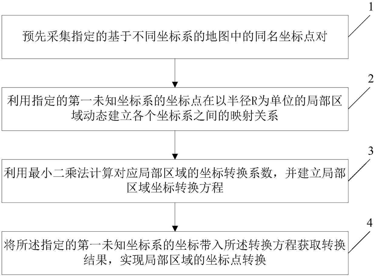
[0026] Embodiments of the present invention will be further described in detail below in conjunction with the accompanying drawings, as figure 1 Shown is a schematic flowchart of a multi-coordinate system fusion method based on coordinate fitting provided by an embodiment of the present invention, and the method includes:

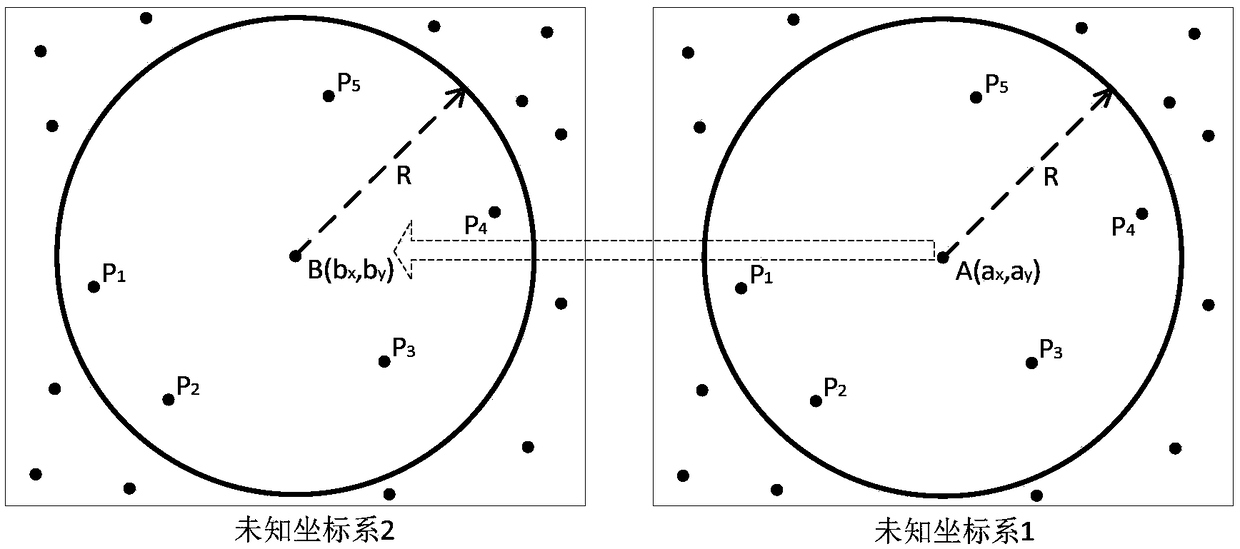
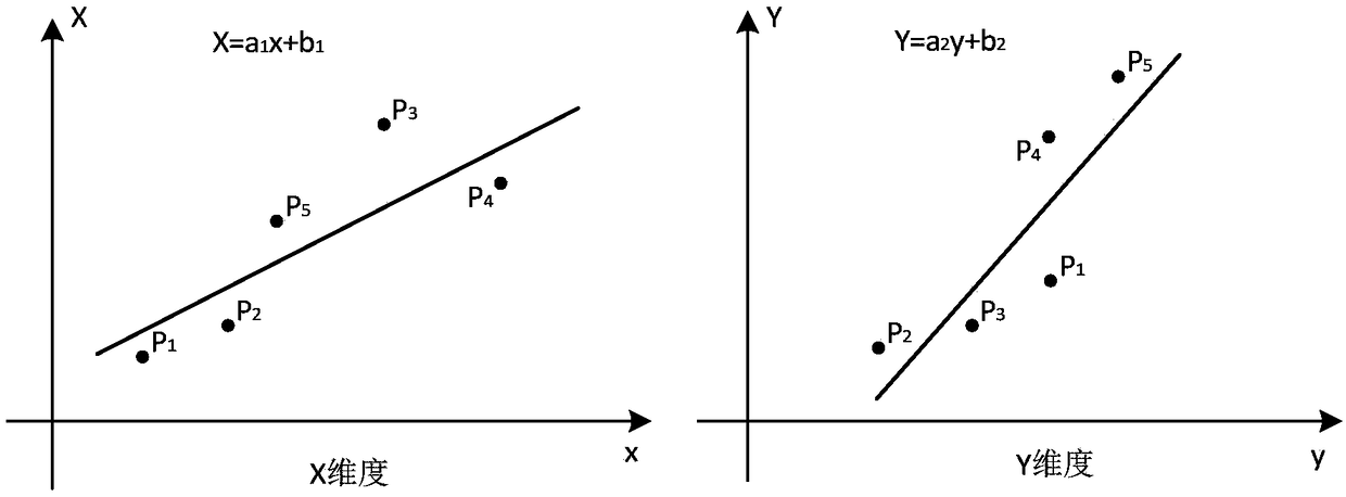
[0027] Step 1. Pre-collect the coordinate point pairs with the same name in the specified map based on different coordinate sy...


PUM


Abstract

The invention discloses a multi-coordinate system fusion method based on coordinate fitting. Firstly, pairs of coordinate points of the same name in a map designated based on different coordinate systems are collected in advance; a mapping relationship between each coordinate system is dynamically established in a local area with a radius R as a unit by using a coordinate point of a designated first unknown coordinate system; the least square method is used to calculate the coordinate transformation coefficients of the corresponding local region, and the coordinate transformation equation of the local region is established. The coordinates of the designated first unknown coordinate system are brought into the conversion equation to obtain the conversion result, and the coordinate point conversion of the local region is realized. This method can effectively realize the conversion between different coordinate systems and lays a foundation for the map linkage function of data visualization system.

Description

technical field [0001] The invention relates to the technical field of geographic information systems, in particular to a multi-coordinate system fusion method based on coordinate fitting. Background technique [0002] At present, in the actual application process of geographic information system, many different coordinate systems are involved, such as: WGS-84 coordinate system, Mars coordinate system (GCJ-02), Xi'an 80 coordinate system, Beijing 54 coordinate system, Baidu coordinate system system (BD-09), etc. These coordinate systems have certain parameters and can be converted according to the parameters. In addition, it also involves local local coordinate systems. The formation of these local local coordinate systems is mainly based on the national coordinate system to formulate a coordinate system in line with the region, thereby forming a local unique regional local coordinate system. The relevant coordinate projection parameters is confidential. [0003] The proce...

Claims


Application Information

Patent Timeline
Patent Type & Authority Applications(China)
IPC IPC(8): G06F17/30
Inventor 周斯来张伟张恩东靳岩林
Owner AEROSPACE INTERNET OF THINGS TECH CO LTD
Why Eureka
Try Eureka