
Remote sensing technology for evaluating growth status of vegetation

A remote sensing technology and growth state technology, applied in the field of environmental protection, can solve problems such as large influence and large atmospheric influence, and achieve the effect of accurately observing the growth state

Inactive Publication Date: 2018-12-14
上饶市中科院云计算中心大数据研究院
View PDF6 Cites 1 Cited by
  • Summary
  • Abstract
  • Description
  • Claims
  • Application Information

AI Technical Summary

Problems solved by technology

[0009] From the above remote sensing vegetation indices for estimating vegetation growth status, it can be known that some of these indices are greatly affected by the background, and some are greatly affected by the atmosphere, and each has its own shortcomings.

Method used


Image

  • Remote sensing technology for evaluating growth status of vegetation
  • Remote sensing technology for evaluating growth status of vegetation
  • Remote sensing technology for evaluating growth status of vegetation

Examples


Embodiment Construction

[0035] The present invention will be further described in detail below through specific embodiments in conjunction with the accompanying drawings.

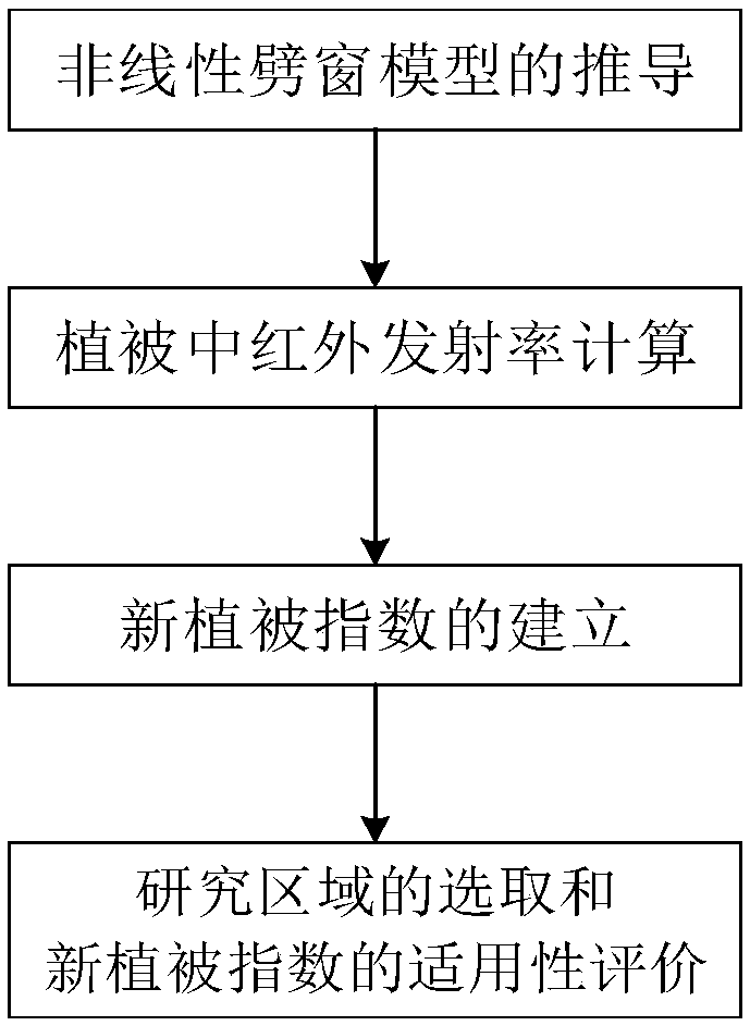
[0036] Such as figure 1 The technical flow diagram of shown the present invention's scheme: at first, deduce and calculate " the radiant energy on the ground when there is no solar direct radiation contribution " Then by Calculate the mid-infrared reflectance ρ b12 ; then by ρ b12 and near-infrared reflectance ρ NIR Establish the new vegetation index VI_M12; the last step calculates the new vegetation index VI_M12 of the present invention on the actual VIIRS image, and compares and verifies it with the traditional normalized difference vegetation index NDVI, and analyzes the applicability of the new vegetation index VI_M12 of the present invention.

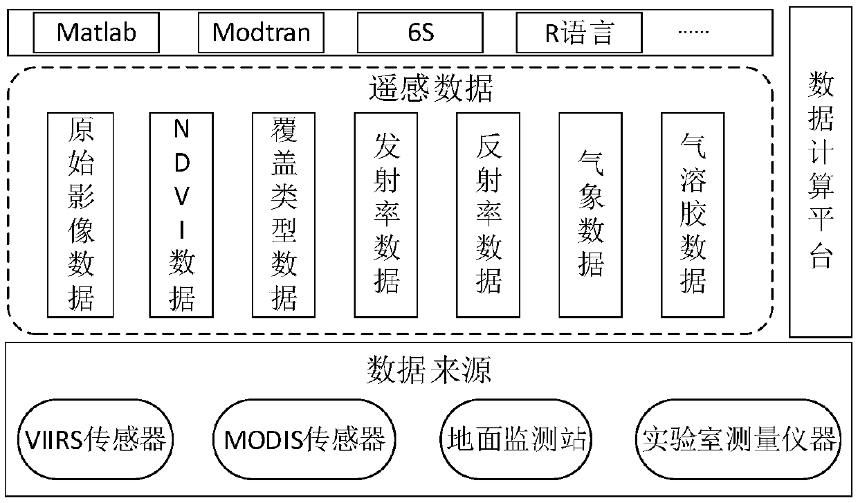
[0037] Such as figure 2 Shown is the data and data processing software framework used in the present invention. VIIR sensor provides VIIRS raw remote sensing image data, inc...


PUM


Abstract

The invention discloses a remote sensing technology for evaluating the growth status of vegetation, and is used in the field of environment protection. The method flow of the remote sensing technologyis as follows: deriving and calculating ground radiation energy without contribution of direct solar radiation Bi(Tg_i<o>); calculating the middle infrared reflectivity rhob12 through Bi(Tg_i<o>); establishing a new vegetation index VI_M12 through rhob12 and the near infrared reflectivity rhoNIR; and evaluating the new vegetation index VI_M12. The method of the remote sensing technology is used to obtain the new vegetation index VI_M12, the vegetation index comprises the reflectivity of the near infrared band and the reflectivity of the middle-infrared band not sensitive to an aerosol, the characteristic that the NDVI (Normalized Differential Vegetation Index) is sensitive to the growth status of the vegetation is kept, the vegetation index also has the advantage that the vegetation indexis not sensitive to the aerosol; therefore, the obtained vegetation index is not sensitive to the weather like smoke dust, the growth status of the ground vegetation is also accurately observed, andthe vegetation index is of great significances for the regional or global problems in the fields of environment, hydrology, weather, zoology, forestry and the like.

Description

technical field [0001] The invention relates to a remote sensing technology in the field of environmental protection, in particular to a remote sensing technology for evaluating vegetation growth state. Background technique [0002] Remote sensing monitoring is currently the mainstream method for evaluating vegetation coverage. Vegetation index is a comprehensive reflection of vegetation type, coverage form, and growth status in a unit pixel. Its size depends on factors such as vegetation coverage, so vegetation growth can be estimated by using vegetation index. So far, a variety of vegetation indices have been developed, mainly as follows: [0003] 1. Normalized difference vegetation index NDVI NDVI=(ρ NIR -ρ R ) / (ρ NIR +ρ R ) (1) [0004] NDVI can reflect the background influence of the plant canopy, such as soil, wet ground, soil, dead leaves, roughness, etc., and is related to vegetation coverage. Its limitation is that it enhances the contrast of NIR and R reflec...

Claims


Application Information

Patent Timeline
Patent Type & Authority Applications(China)
IPC IPC(8): G01N21/17
CPCG01N21/17G01N2021/1793
Inventor 贺丽琴苏环
Owner 上饶市中科院云计算中心大数据研究院
Learn More