A method of enhanced satellite-based navigation using low earth orbit satellites

A low-orbit satellite and satellite-based technology, applied in the satellite field, can solve the problems of high construction cost, ground-based enhancement system cannot solve wide-area enhancement, and large system, so as to improve convergence speed, improve availability monitoring, and improve geometric configuration. Effect

Active Publication Date: 2018-12-21
SHANGHAI SATELLITE ENG INST
View PDF5 Cites 23 Cited by
  • Summary
  • Abstract
  • Description
  • Claims
  • Application Information

AI Technical Summary

Problems solved by technology

However, the ground-based augmentation system cannot solve the problem of wide-area augmentation and cannot cover the ocean. A single base station can cover

Method used


Image

  • A method of enhanced satellite-based navigation using low earth orbit satellites
  • A method of enhanced satellite-based navigation using low earth orbit satellites
  • A method of enhanced satellite-based navigation using low earth orbit satellites

Examples


Example Embodiment

[0037] The present invention will be described in detail below in conjunction with specific embodiments. The following examples will help those skilled in the art to further understand the present invention, but do not limit the present invention in any form. It should be noted that those skilled in the art can make several modifications and improvements without departing from the concept of the present invention. These all belong to protection domain of the present invention.

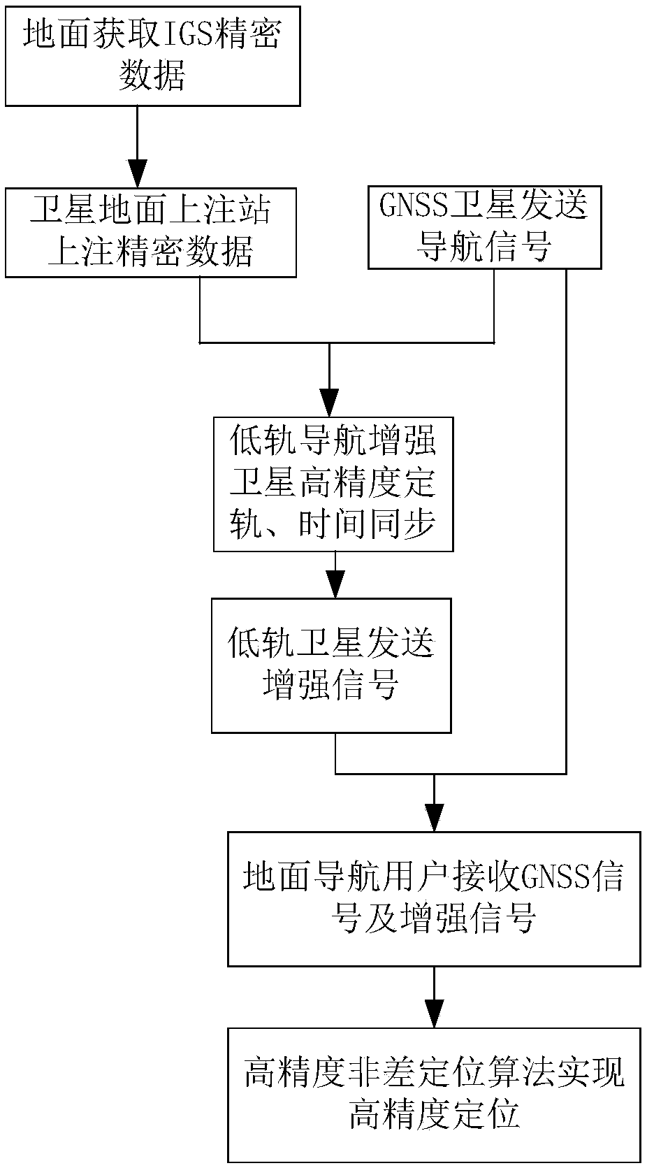
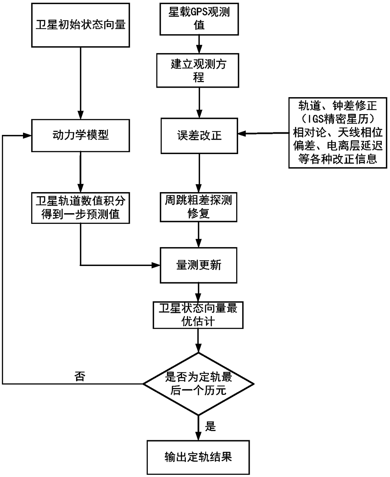
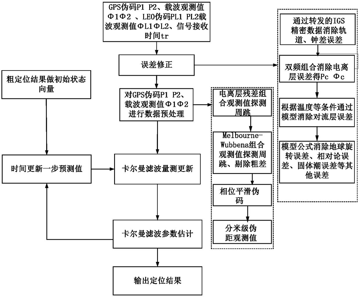
[0038] like Figure 1 to Figure 3 As shown, the present invention utilizes low-orbit satellites to carry out the method for satellite-based navigation enhancement comprising the following steps:

[0039] Step 1: Obtain IGS precision ephemeris and clock data, GNSS system integrity early warning data, ionospheric correction parameters, etc. through the Internet, and the ground station uploads the data to the low-orbit navigation enhancement satellite through the upload channel;

[0040] Step 2: The lo...


PUM


Abstract

The invention provides a method of enhanced satellite-based navigation using low earth orbit (LEO) satellites and comprises the following steps. Step 1: obtaining through the Internet the IGS precisesatellite ephemeris and satellite clock data, the GNSS system integrity warning data, and the corrected ionosphere parameters, etc., and uploading the data from ground station to LEO navigation satellite through the upload channel. Step 2: completing the real-time, high-precision positioning and the high-precision timing of the satellite in orbit. Step 3: the LEO navigation satellite compiles itsorbital parameters, the precise IGS data, and the corrected ionosphere parameters for transmission. Step 4: the high-precision receiver on ground receives the GNSS signal and the LEO satellite navigation signal and outputs the high-precision navigation and positioning. The invention makes real-time and high-precision orbit determination and provides enhanced navigation for users on the ground based on the uploaded precise IGS satellite ephemeris data and the high-precision dynamic model.

Description

technical field [0001] The invention relates to the field of satellites, in particular to a method for enhancing satellite-based navigation by using low-orbit satellites. Background technique [0002] Global Navigation Satellite System (GNSS), especially the GPS system in the United States, the GLONASS system in Russia, the Galileo system in Europe and the Beidou system in China, have been widely used around the world, providing navigation and positioning services for users in various fields. However, with the promotion of applications, the current fields of high-precision surveying and mapping, precision agriculture, transportation and logistics, and aviation management have higher and higher requirements for navigation and positioning accuracy, availability, and integrity. The traditional GNSS system can no longer meet the needs. [0003] Current navigation augmentation technologies include satellite-based augmentation using high-orbit satellites (GEO) and ground-based aug...

Claims


Application Information

Patent Timeline
IPC IPC(8): G01S19/08
CPCG01S19/08
Inventor 梁尔涛张伟章英杰郑永艾施伟璜
Owner SHANGHAI SATELLITE ENG INST
Why Eureka
Try Eureka