Method for determining the optimal segmentation scale of satellite image segmentation based on information gain ratio

A technology of information gain rate and satellite imagery, applied in the directions of instruments, character and pattern recognition, computer parts, etc., can solve the problems of limited application and complicated method application, and achieve the effect of improving the effect and improving the accuracy of image classification.

Active Publication Date: 2018-12-21
ZHEJIANG UNIV
View PDF9 Cites 1 Cited by
  • Summary
  • Abstract
  • Description
  • Claims
  • Application Information

AI Technical Summary

Problems solved by technology

However, the supervised optimal segmentation scale determination method that is currently widely used is mainly based on topological or geometric metrics to evaluate t

Method used


Image

  • Method for determining the optimal segmentation scale of satellite image segmentation based on information gain ratio
  • Method for determining the optimal segmentation scale of satellite image segmentation based on information gain ratio
  • Method for determining the optimal segmentation scale of satellite image segmentation based on information gain ratio

Examples


Embodiment Construction

[0030] The present invention will be further described below in conjunction with the accompanying drawings and implementation examples.

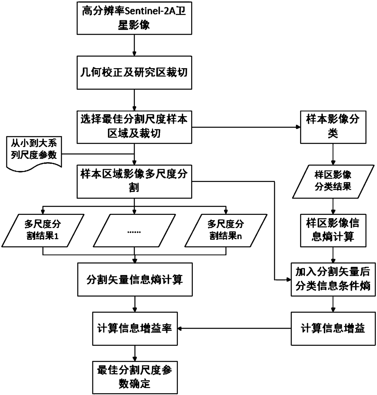
[0031] like figure 1As shown, it is a flow chart of the method for determining the optimal segmentation scale of satellite image segmentation based on information gain rate in the present invention. First, for the acquired high-resolution Sentinel-2A or other high-resolution images, geometric correction and image cropping of the research area are performed , to obtain the multispectral image of the study area. Since the types of ground objects in the study area are complex, and the optimal segmentation scales of different ground objects are often different, it is necessary to select the sample area according to the specific conditions of the target category, which can reduce the amount of calculation and improve the accuracy. After obtaining the sample area, use visual interpretation, supervised classification (maximum likelihood classifica...


PUM


Abstract

The invention discloses a method for determining the optimal segmentation scale of satellite image segmentation based on information gain rate, includes obtaining high-resolution satellite remote sensing image, preprocessing, selecting representative region as sample region determined by optimal segmentation scale, classifying surface features of sample region, obtaining image classification result of sample region as reference image determined by optimal segmentation scale, and obtaining image classification result of sample region as reference image determined by optimal segmentation scale;setting a series of segmentation scale parameters from small to large, using multi-scale segmentation technology, the sample image is segmented in multi-scale to obtain a series of segmented object vectors; Based on Shannon information entropy formula, the information entropy of reference image and segmentation vector is calculated, and the conditional entropy of reference image with segmentationvector is calculated, then the information gain and information gain ratio of segmentation vector are calculated. The optimal segmentation scale is selected according to the principle of maximum information gain rate. Finally, based on the optimal segmentation scale, the original image is segmented at multiple scales.

Description

technical field [0001] The invention relates to the technical field of object-oriented image segmentation parameter selection, in particular to a method for determining the optimal segmentation scale of satellite image segmentation based on information gain ratio. Background technique [0002] In recent years, with the continuous launch of various satellites, the available data sources for crop monitoring are increasing, and crop identification based on multi-source satellite remote sensing data has become a new trend, which better solves the defect of insufficient temporal resolution of a single satellite image. (Sharma et al. 2017; Colkesen and Kavzoglu 2017; Morton et al. 2011; Novelli et al. 2016). However, the spatial resolution of different satellite data is often inconsistent. The traditional pixel-based method needs to use resampling to make the resolution consistent (Mansaray et al.2017; Sharma et al.2017), but mixed pixel and scale effects The existence of restric...

Claims


Application Information

Patent Timeline
IPC IPC(8): G06K9/00G06K9/34G06K9/62
CPCG06V20/188G06V10/267G06F18/23G06F18/24
Inventor 杨玲波黄敬峰
Owner ZHEJIANG UNIV
Why Eureka
Try Eureka