
Crown projection measurement method and system based on azimuth and distance

A technology of canopy projection and measurement method, applied in the field of canopy projection, can solve the problems of financial constraints, complex data processing of high-resolution remote sensing image method, low applicability, etc., to achieve the effect of high-efficiency measurement

Pending Publication Date: 2018-12-28
HEBEI AGRICULTURAL UNIV.
View PDF5 Cites 1 Cited by
  • Summary
  • Abstract
  • Description
  • Claims
  • Application Information

AI Technical Summary

Problems solved by technology

The time resolution of satellite high-resolution remote sensing images is low, and usually only the previous remote sensing images can be used, and the current tree crown projection cannot be obtained; while aerial high-resolution remote sensing images can obtain the current tree crown state, but the price is too expensive. Often limited by funding, low applicability
The data processing of high-resolution remote sensing image method is complicated, and the connected tree canopy boundaries cannot be accurately distinguished

Method used


Image

  • Crown projection measurement method and system based on azimuth and distance
  • Crown projection measurement method and system based on azimuth and distance
  • Crown projection measurement method and system based on azimuth and distance

Examples


specific Embodiment 1

[0076] The first step is to conduct a survey in the forest and around the trees to be measured to understand the current status of forest stands and canopies. Look up to observe the shape of the edge of the tree crown and its positional relationship with the surrounding trees, and obtain the corresponding ground projection point of the tree crown to be measured.

[0077] In the second step, use a ruler to measure the DBH position of the trunk at 1.3m from the ground. If it is on a slope, measure the DBH position at the uphill position of the tree. Make a mark at the DBH position, measure the DBH with a bust ruler, accurate to 0.1cm, and calculate the trunk radius r of the tree to be measured.

[0078] In the third step, according to the ground projection point obtained in the first step, select a projection point that is easy to identify as the first point, record it as point A and mark it. Taking point A as the measuring station, use a laser range finder (with azimuth measur...


PUM


Abstract

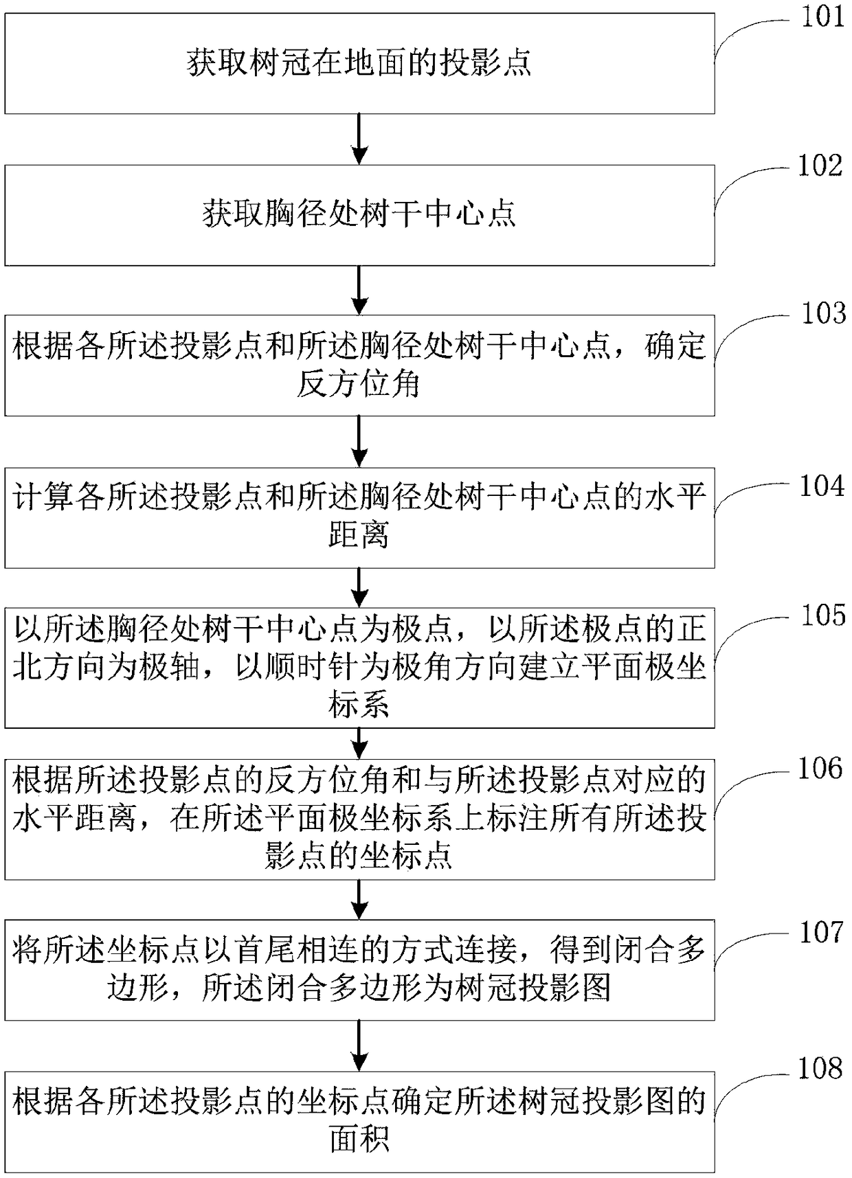
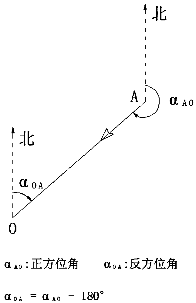
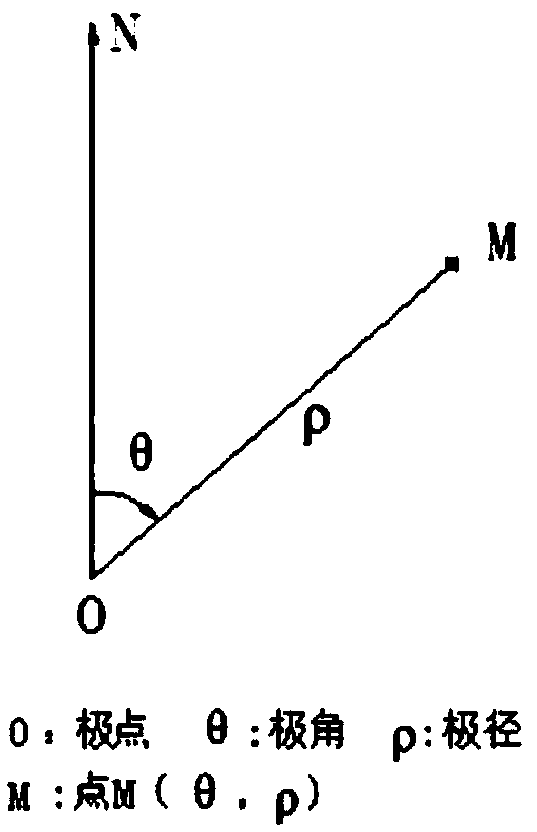
The invention discloses a crown projection measurement method and system based on an azimuth and a distance. The method comprises the following steps: acquiring projection points of a crown on the ground; acquiring a trunk center point at the diameter at breast height; determining reverse azimuths according to the projection points and the trunk center point at the diameter at breast height; calculating the horizontal distance between each projection point and the trunk center point at the diameter at breast height; establishing planar polar coordinates by taking the trunk center point at thediameter at breast height as a polar point, taking the north direction of the polar point as a polar axis, and taking a clockwise direction as a polar angle direction; marking coordinate points of allthe projection points on the planar polar coordinates according to the reverse azimuths of the projection points and horizontal distances corresponding to the projection points; connecting coordinatepoints end to end to obtain a closed polygon, wherein the closed polygon is a crown projection; and determining the area of the crown projection according to the coordinate points of the projection points. Through adoption of the method or the system disclosed by the invention, the shape and area of the crown projection can be measured rapidly, accurately and efficiently.

Description

technical field [0001] The invention relates to the field of tree crown projection, in particular to a tree crown projection measurement method and system based on azimuth and distance. Background technique [0002] The size of the canopy reflects the growth space and competitiveness of the tree, and the canopy projection is a direct reflection of the size, shape and area of ​​the canopy, and is a commonly used indicator in forestry and ecology. The crown of scattered trees is usually approximately circular or oval, and it is relatively easy to measure. In forests, due to differences in tree species, growth environments, and competition from adjacent trees, the shape of the canopy varies greatly. Accurate measurement of the canopy is a tedious and time-consuming task. The measurement of tree crown projection includes direct distance measurement method, total station measurement method, laser point cloud method, and high-resolution remote sensing image method. Many problems...

Claims


Application Information

Patent Timeline
Patent Type & Authority Applications(China)
IPC IPC(8): G01B11/24G01B11/28
CPCG01B11/2433G01B11/28
Inventor 李永宁卢伟
Owner HEBEI AGRICULTURAL UNIV.
Learn More