Long-distance network RTK tropospheric delay estimation method based on BP neural network

A BP neural network and tropospheric delay technology, applied in the field of satellite navigation and positioning, can solve problems such as the reduction of spatial error correlation and the increasing difficulty of tropospheric delay estimation, so as to increase the number of samples, improve real-time performance and accuracy, and ensure accuracy and reliability effects

Inactive Publication Date: 2019-01-01
XIAMEN UNIV OF TECH
View PDF7 Cites 4 Cited by
  • Summary
  • Abstract
  • Description
  • Claims
  • Application Information

AI Technical Summary

Problems solved by technology

When the distance between reference stations increases (150-200km), the spatial error correlation decreases, and the difficulty of tropospheric delay estimation

Method used


Image

  • Long-distance network RTK tropospheric delay estimation method based on BP neural network
  • Long-distance network RTK tropospheric delay estimation method based on BP neural network
  • Long-distance network RTK tropospheric delay estimation method based on BP neural network

Examples


Embodiment Construction

[0041] To further illustrate the various embodiments, the present invention is provided with accompanying drawings. These drawings are a part of the disclosure of the present invention, which are mainly used to illustrate the embodiments, and can be combined with related descriptions in the specification to explain the operating principles of the embodiments. With reference to these contents, those skilled in the art should understand other possible implementations and advantages of the present invention.

[0042] The present invention will be further described in conjunction with the accompanying drawings and specific embodiments.

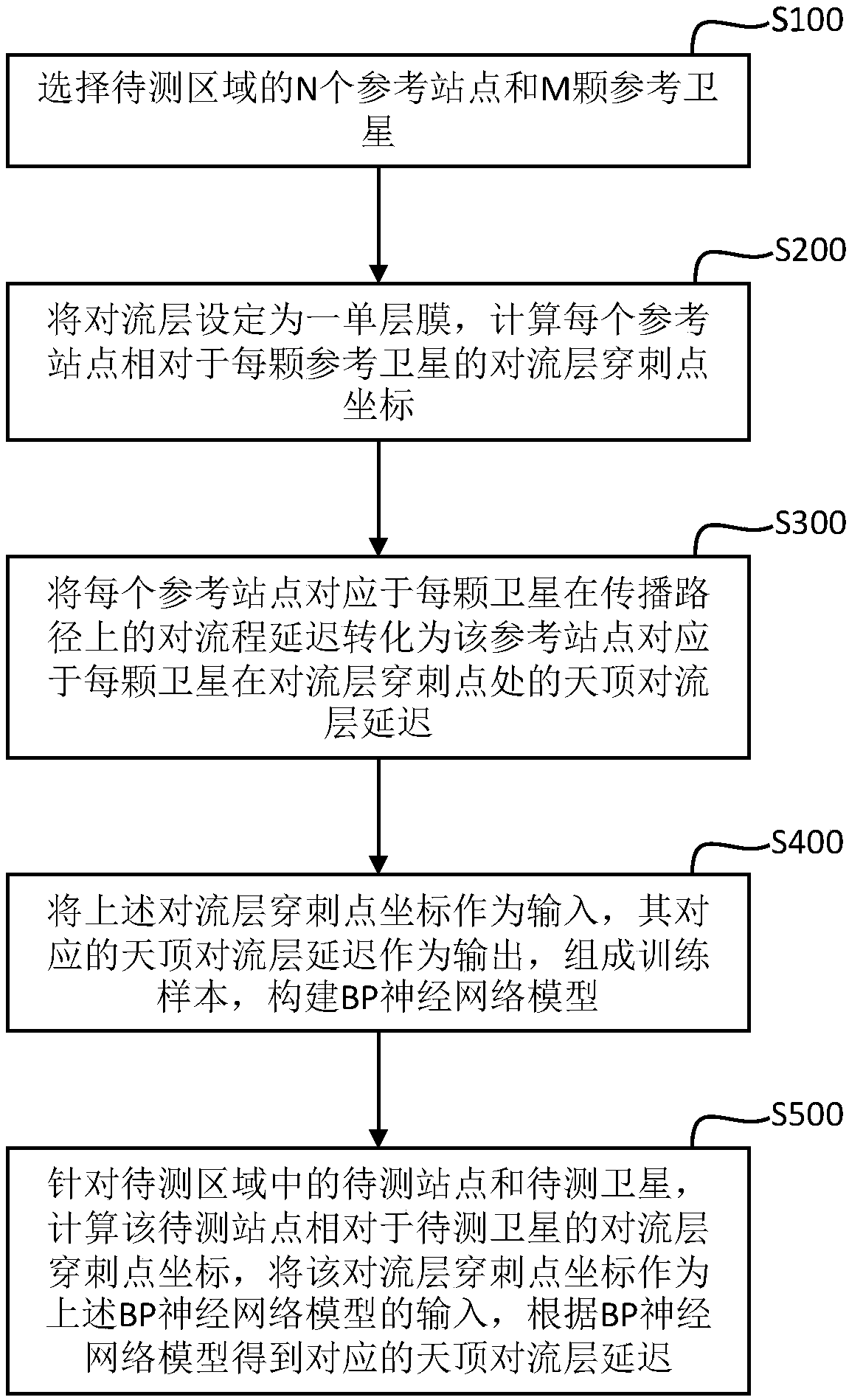
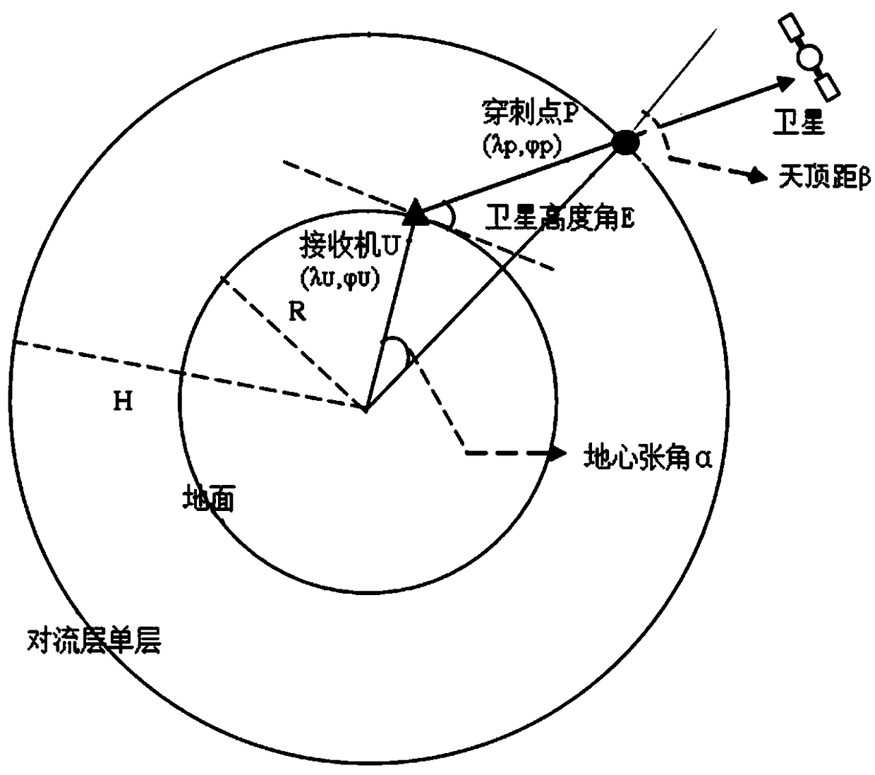
[0043] Such as figure 1 As shown, the embodiment of the present invention provides a BP neural network-based long-distance network RTK tropospheric delay estimation method, which is different from the conventional BP neural network estimation method for the tropospheric layer. The problem that the present invention intends to solve is to calculat...


PUM


Abstract

The invention relates to a long-distance network RTK tropospheric delay estimation method based on a BP neural network. The method comprises the following steps: S100: N reference stations and M reference satellites of a region to be tested are selected; S200: tropospheric puncture point coordinates of each reference station relative to each reference satellite are calculated; S300: the tropospheric delay of each reference station on a propagation path is converted to zenith tropospheric delay at tropospheric puncture points; S400: the above tropospheric puncture point coordinates are taken asinput, corresponding zenith tropospheric delay is taken as output to form a training sample to construct a BP neural network model; S500: for stations to be tested and satellites to be tested in an area to be tested, the coordinates of the tropospheric puncture points are taken as input, and corresponding zenith tropospheric delay is obtained according to the BP neural network model. According tothe method disclosed in the invention, the BP neural network model is established to estimate the tropospheric delay between user stations and corresponding satellites, and therefore real-time properties and accuracy of station RTK measurement and positioning can be improved.

Description

technical field [0001] The invention relates to the technical field of satellite navigation and positioning, in particular to a BP neural network-based long-distance network RTK tropospheric delay estimation method. Background technique [0002] Today, with the rapid development of satellite navigation and positioning technology, network RTK technology based on ground enhancement can provide end users with real-time centimeter-level high-precision dynamic positioning services, and has been widely used at home and abroad. At present, GPS, GLONASS, and BDS are all navigation systems that use radio wave transmission time to calculate the user's position. The range of about 18km from the ground is considered to be the troposphere, and the propagation of electromagnetic waves in the frequency range of 15 to 30GHz is considered to be a non-dispersive medium. This causes delay in signal transmission. In network RTK relative positioning, the tropospheric delay is a space-related er...

Claims


Application Information

Patent Timeline
IPC IPC(8): G01S19/20G01S19/28G01S19/33G06N3/08
CPCG01S19/20G01S19/28G01S19/33G06N3/084
Inventor 邓健许妙强何原荣
Owner XIAMEN UNIV OF TECH
Why Eureka
Try Eureka