Multi-satellite scheduling method for large-area target observation

A scheduling method and large-area technology, applied in the field of satellite scheduling, can solve the problems of difficult observation planning and long time consumption

Active Publication Date: 2019-01-08
NAT UNIV OF DEFENSE TECH
View PDF4 Cites 19 Cited by
  • Summary
  • Abstract
  • Description
  • Claims
  • Application Information

AI Technical Summary

Problems solved by technology

With the expansion of the observation target area, the increase of observation requirements from different customers, the increase of search space and candidate solu

Method used


Image

  • Multi-satellite scheduling method for large-area target observation
  • Multi-satellite scheduling method for large-area target observation
  • Multi-satellite scheduling method for large-area target observation

Examples


Embodiment Construction

[0099] The technical solution of the present invention will be further shown and described below in conjunction with the accompanying drawings of the description.

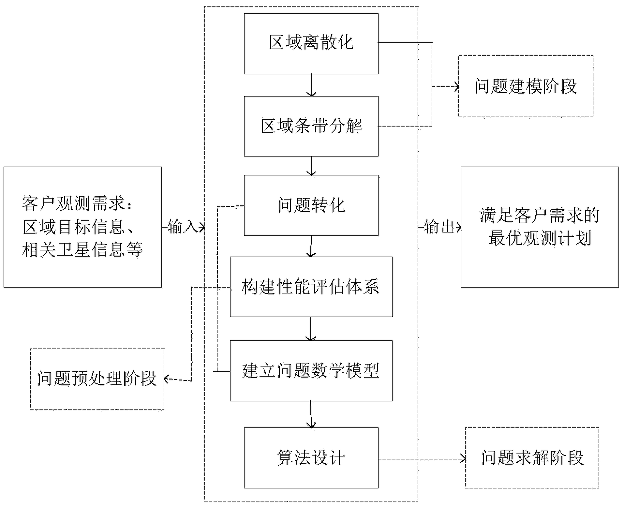
[0100] refer to figure 1 , is a flowchart of the present invention. Among them, the input of the problem includes observation requirements from customers, such as regional target information, related satellite information, image requirement information, etc., and the output of the problem is the optimal observation plan to meet customer needs. The problem-solving framework consists of three stages: problem preprocessing, problem modeling and problem solving. The problem preprocessing stage includes regional discretization and regional strip decomposition. The problem modeling stage includes problem transformation, building a performance evaluation system, and establishing a mathematical model of the problem. The problem solving stage includes algorithm selection and design.

[0101] Specifically, a multi-satellit...


PUM


Abstract

The invention provides a multi-satellite scheduling method for large-area target observation. Firstly, according to the user's demand, the observation task is determined, that is to say, the target area T (i.e., the position and area of the known target area) to be observed is determined. A set of available satellites S and satellite parameter information for all available satellites in the set ofavailable satellites S are determined. Then the target region is discretized and the target region is decomposed into stripes. The method converts the multi-satellite scheduling problem oriented to large-area target observation into a set covering problem with a plurality of constraints, and establishes a mathematical model. Finally, the mathematical model established in S4 is solved by genetic algorithm, and the output is the observation plan obtained from the solution. The method solves the problem that the satellite image acquisition method related to the current environmental protection activities consumes long time and has the phenomenon of coverage omission, and the method of the invention can obtain a feasible observation scheme with higher target coverage rate for a specific observation area.

Description

technical field [0001] The invention relates to the technical field of satellite scheduling, in particular to a multi-satellite scheduling method for large-area target observation. Background technique [0002] The Earth Observation Satellite (EOS) is a space platform system that can obtain images of specific areas on the Earth's surface according to various observation needs. Due to its high reliability, convenience and high efficiency, EOS image acquisition has been widely recognized by many customers such as government agencies, research institutions and commercial enterprises. In recent years, due to frequent human activities, deteriorating natural environment, and frequent occurrence of natural disasters, environmental protection activities have received more and more attention, such as land surveying and mapping, environmental monitoring, land desertification monitoring, tropical rainforest protection, Antarctic ice sheet monitoring and other activities in the world. ...

Claims


Application Information

Patent Timeline
IPC IPC(8): G06Q10/06G06N3/12
CPCG06N3/126G06Q10/0631
Inventor 刘晓路许英杰姚锋陈盈果陈成王涛吕济民陈宇宁
Owner NAT UNIV OF DEFENSE TECH
Why Eureka
Try Eureka