

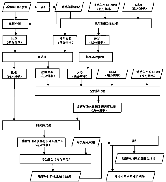
A spatial downscaling method for remotely sensed daily precipitation data
A precipitation and downscaling technology, which is applied in the direction of instruments, character and pattern recognition, computer components, etc., can solve the problems of inability to downscale and low precision of daily precipitation in remote sensing, so as to improve monitoring ability and spatial resolution and precision, broad application prospects
- Summary
- Abstract
- Description
- Claims
- Application Information
AI Technical Summary
Problems solved by technology
Method used
Image

Examples
Embodiment Construction
[0040] The specific implementation manner of the present invention is described in detail below in conjunction with accompanying drawing and embodiment
[0041]The selected remote sensing precipitation data is the IMERG daily precipitation data in 2015, with a spatial resolution of 0.1°; the DEM data comes from SRTM, with a spatial resolution of 90 meters; the NDVI data comes from PROBA-V S10TOC NDVI (10-day synthesis), with 1km spatial resolution. The study area is part of central and western China, with latitude and longitude ranging from 25°N to 38°N and 105°E to 118.5°E; the daily precipitation observation data obtained by meteorological stations comes from the National Meteorological Administration, and there are 289 80% of the daily station observations are used for model building, and the remaining 20% are used for final accuracy verification.
[0042] The specific embodiment of the inventive method comprises the following steps:
[0043] Step I. Data Preprocessing ...
PUM
 Abstract
Description
Claims
Application Information