Visual obstacle avoidance method based on distributed map for unmanned aerial vehicle

A UAV, distributed technology, applied in non-electric variable control, instruments, control/regulation systems, etc., can solve problems such as UAV damage, time-consuming storage resources, obstacle damage, etc., to reduce the burden, The effect of improving processing efficiency and improving performance

Active Publication Date: 2019-02-19
NANJING UNIV OF AERONAUTICS & ASTRONAUTICS
View PDF7 Cites 21 Cited by
  • Summary
  • Abstract
  • Description
  • Claims
  • Application Information

AI Technical Summary

Problems solved by technology

[0003] There are mainly two existing UAV visual obstacle avoidance methods, one is UAV autonomous obstacle avoidance navigation, this method needs to generate a new environment map for each frame of image, and store it in the UAV itself. In the storage system, obstacles are recognized in real time on the environmental map to avoid obstacles and fly. This has high requirements for the data processing system and data storage system of the UAV itself. The processing speed under various environmental conditions , storage capacity and processing stability should be excellent in order to cope with complex and changeable usage scenarios, resulting in higher cost of drones; the other is through the combination of drones and ground stations, the status and The environmental data are all sent to the ground station for processing, and the UAV executes the flight according to the flight instructions obtained by the ground station after processing the data, so that the cost of the UAV will be greatly reduced, and due to irresistible natural factors such as lightning Human-machine damage, such losses will be greatly reduced
At present, the UAV obstacle avoidance realized by the combination of the UAV and the ground station needs to generate a new environment map for each frame of image acquired by the UAV. This solution is very time-consuming and takes up a lot of storage resources, which is very efficient Low, once the ground station does not handle it in time, the drone will not be able to identify obstacles in time and be damaged

Method used


Image

  • Visual obstacle avoidance method based on distributed map for unmanned aerial vehicle
  • Visual obstacle avoidance method based on distributed map for unmanned aerial vehicle
  • Visual obstacle avoidance method based on distributed map for unmanned aerial vehicle

Examples


Embodiment Construction

[0028] The technical solutions of the present invention will be further described below in conjunction with the accompanying drawings and embodiments.

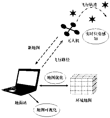
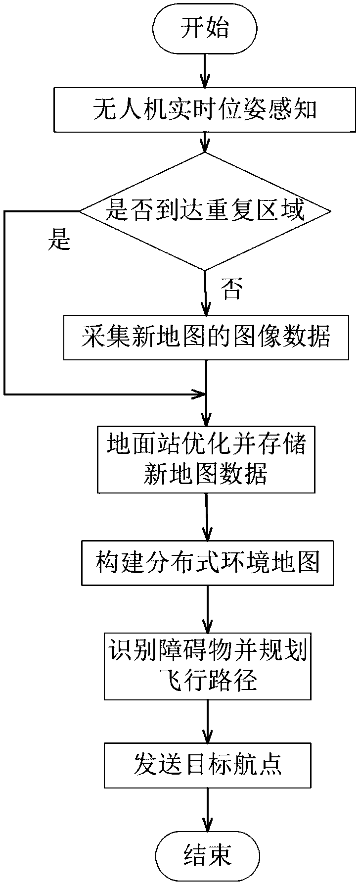
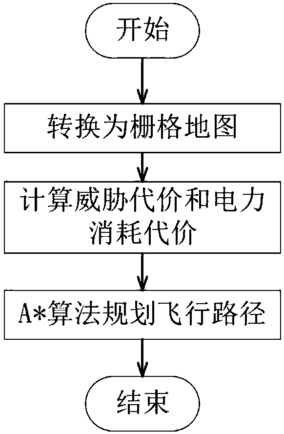
[0029] figure 1 It is a schematic diagram of the distributed map-based UAV visual obstacle avoidance method of the present invention. The system consists of two parts, the UAV and the ground station, which communicate through WiFi. The drone performs real-time pose perception to determine whether it has reached a repeated area. If it is judged to be an unreached area, the drone performs image data collection and related calculations, and the calculated point cloud 3D coordinate data and its own The flight status data is sent to the ground station, which is responsible for optimizing and storing these data, and constructing a distributed environment map through the processed data, then identifying obstacles in the new map and planning the flight path, and finally the ground station will plan the planned flight The command is ...


PUM


Abstract

The invention discloses a visual obstacle avoidance method based on a distributed map for unmanned aerial vehicles. The distributed map is constructed by the cooperation of the unmanned aerial vehicleand a ground station, and is used for visual obstacle avoidance flight. The unmanned aerial vehicle generates a new environment map only after entering a new environment by combining IMU, VO, GPS, and real-time pose sensing; the unmanned aerial vehicle receives a flight instruction sent by the ground station, and controls the flying of the unmanned aerial vehicle through changing the rotation speed of four motors to realize the visual obstacle avoidance; the ground station is used for optimizing and storing the environment map constructed by the unmanned aerial vehicle, and visualizing the environment map; and meanwhile, the ground station is also responsible for planning a safe flying route according to the current pose and the current environment map of the unmanned aerial vehicle, andsending the safe flying route to the unmanned aerial vehicle. According to the visual obstacle avoidance method based on the distributed map for the unmanned aerial vehicle, by means of the cooperation of the unmanned aerial vehicle and the ground station, and the architecture of the distributed map, the environment is accurately modeled; and the invention is suitable for visual obstacle avoidanceof the unmanned aerial vehicle in complex environments.

Description

technical field [0001] The invention relates to an obstacle avoidance method for an unmanned aerial vehicle, in particular to a visual obstacle avoidance method based on a distributed map, and belongs to the technical field of autonomous navigation of an unmanned aerial vehicle. Background technique [0002] Unmanned Aerial Vehicle (UAV) has evolved from a simple aerial vehicle to a flightable multifunctional intelligent platform, playing an increasingly important role in the civil and military fields. With the emergence of various application requirements, UAVs need to perform specific tasks in complex environments. How to make UAVs recognize obstacles and avoid obstacles has become one of the key technologies of UAVs. Visual obstacle avoidance means that by simulating the eyes of animals, the drone can perceive the environment during flight, build a three-dimensional map, and identify obstacles, so as to avoid obstacles and fly. [0003] There are mainly two existing UAV ...

Claims


Application Information

Patent Timeline
Patent Type & Authority Applications(China)
IPC IPC(8): G05D1/10
CPCG05D1/101
Inventor 刘阳王从庆李翰
Owner NANJING UNIV OF AERONAUTICS & ASTRONAUTICS
Why Eureka
Try Eureka