Ship traffic management method and system for smart navigation mark

A technology of ship traffic management and aids to navigation, which is applied in ship traffic control, traffic control systems, instruments, etc., can solve the problems of traffic alarm warning efficiency decline, limited radar beam width, and untimely risk discovery, so as to improve the effect of warning communication, Improve the success rate of communication and the effect of improving traffic efficiency

Pending Publication Date: 2019-02-19
FUZHOU UNIV
View PDF9 Cites 13 Cited by
  • Summary
  • Abstract
  • Description
  • Claims
  • Application Information

AI Technical Summary

Problems solved by technology

[0002] The buoy is an important water traffic facility for identifying reefs, indicating waterways, and guiding navigation. At present, the traditional buoy only has the function of light indication, which cannot meet the management needs of modern water traffic. Therefore, it is necessary to develop a water traffic behavior perception ability and risk notification. Intelligent navigation mark
[0003] Since the buoys are installed on inland rivers and seas, they cannot be powered by the existing power grid. Most of them use solar energy or tidal energy. Therefore, the energy supply is limited, and it is impossible to use power-consuming sensing and communication technologies on the buoys.
For example, the most mature active sensing technology-radar technology, due to the limited radar beam width, in order to be able to search the entire sea surface, a dual-motor pan / tilt is required to control the horizontal and vertical movements separately. The motor is used as a power device that converts electrical energy into mechanical energy. The amount is large, limited by the area, the energy collected by solar cells is limited, and it cannot supply the energy consumption of the motor pan / tilt for 24 hours
There are also methods such as laser three-dimensional scanning, ultrasonic detection, etc., and such technologies need to actively launch energy waves to water sports targets at a distance of 1-3km, and determine moving targets by detecting reflected waves, so only energy waves are sent to A long distance will consume a lot of energy. The overall volume of offshore facilities limits the area of ​​solar panels, so it cannot provide sufficient energy. Therefore, it is necessary to consider the feasibility of energy consumption when setting smart navigation marks
[0004] The patent document with the announcement number CN102514694B, in order to solve the problem of high power consumption of radar perception, discloses a "navigation mark with annular phased array radar", through 24 phased array antennas arranged in a ring, the 360-degree scanning method adopts electronic control Instead of mechanical rotation, it reduces energy consumption to a certain extent
But no matter how optimized, the energy consumption of 24 radar antennas exploring more than 3 kilometers will still become a huge burden on the solar cells
In addition, the visualization effect of radar is average. If the navigation mark is established along the coast, it will be difficult to distinguish moving vehicles on land from ships at sea.
[0005] In addition to navigation marks, VTS (Vessel Traffic System, Vessel Traffic Management) and AIS (Automatic Identification System, Vessel Automatic Identification System) are also important ways in the application of Vessel Traffic Management at present, but as far as the current usage is concerned, the combination of the two is common. Heavy work tasks, information lag, misidentification of risks, and untimely risk discovery
Moreover, most of the methods of traffic command and risk notification adopt the macro command mode, that is, broadcast command commands to ships in a large area, such as ship traffic radio stations, variable information boards along the way, etc. The commands are unified and simple, not Conducive to the improvement of macro-regional traffic efficiency
For individual ships, most of the road condition information and accident information are irrelevant to themselves, so for each individual micro ship, there is too much garbage information, and effective information related to its own safety is easily submerged in a sea of ​​irrelevant information , so there is a driving psychology of being outside, and the vigilance is reduced, resulting in a decrease in the effectiveness of traffic warning warnings

Method used


Image

  • Ship traffic management method and system for smart navigation mark
  • Ship traffic management method and system for smart navigation mark
  • Ship traffic management method and system for smart navigation mark

Examples


Embodiment 1

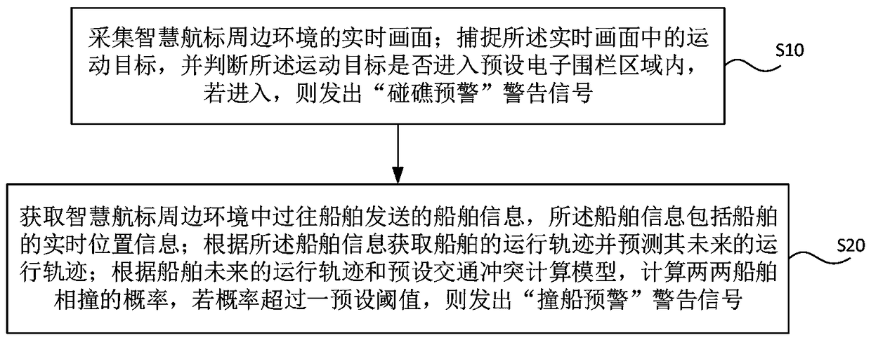
[0058] Such as figure 1 , figure 2 As shown, the present embodiment provides a method for managing ship traffic of intelligent navigation marks, including the following steps:

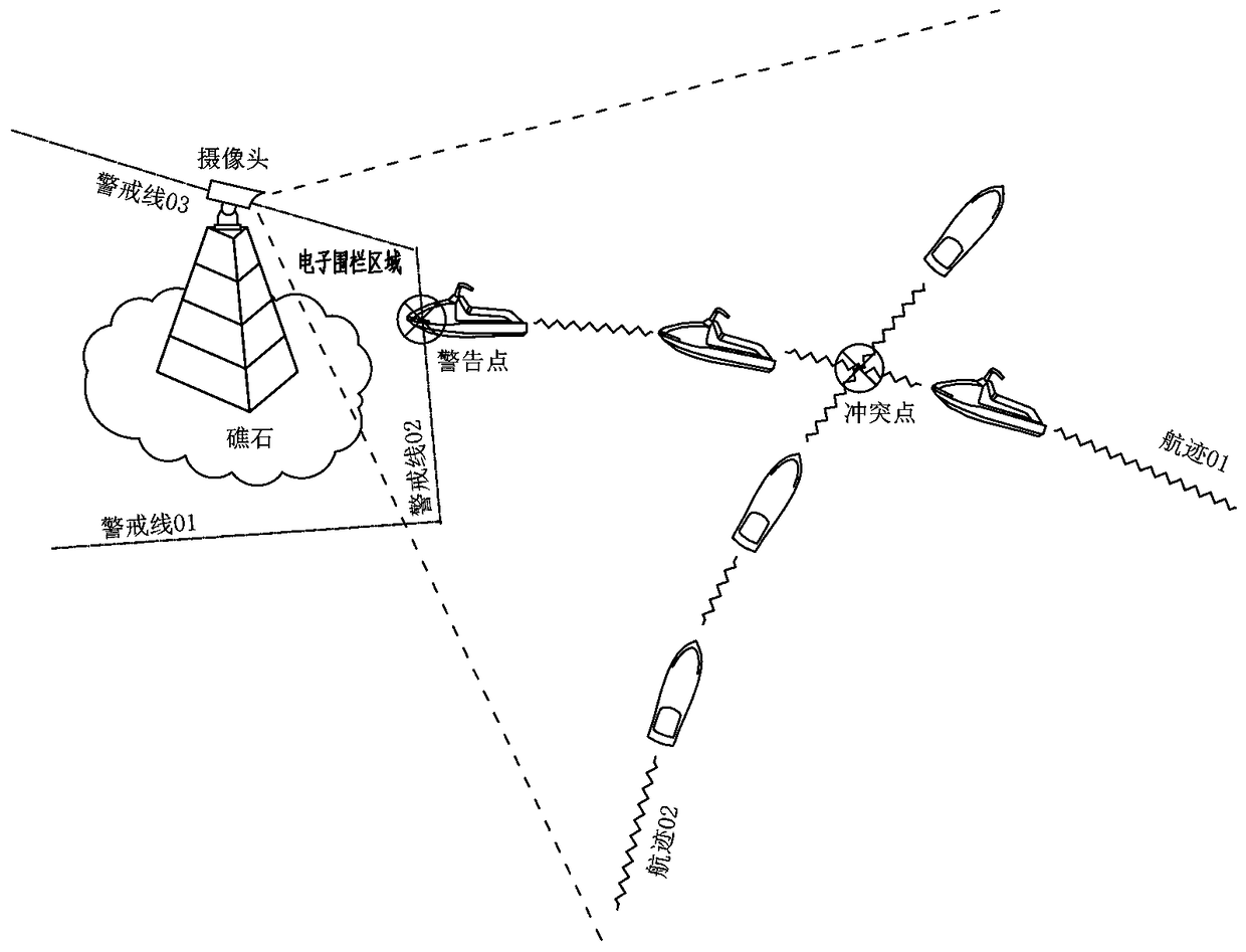
[0059] S10: Collect a real-time picture of the surrounding environment of the smart navigation mark; capture the moving target in the real-time picture, and judge whether the moving target enters the preset electronic fence area, and if it enters, issue a warning signal of "warning against reefs";

[0060] The method in this step is mainly applied to smart navigation aids. The installation and setting of the smart navigation aids body is the same as that of conventional navigation aids in the prior art, that is, it is set on inland rivers or offshore seas. However, in order to ensure the risk assessment and warning prompts of this program In order to ensure the accuracy, it should be noted that the position of the smart navigation mark is fixed, and it is preferable to set the smart navigation mark o...

Embodiment approach

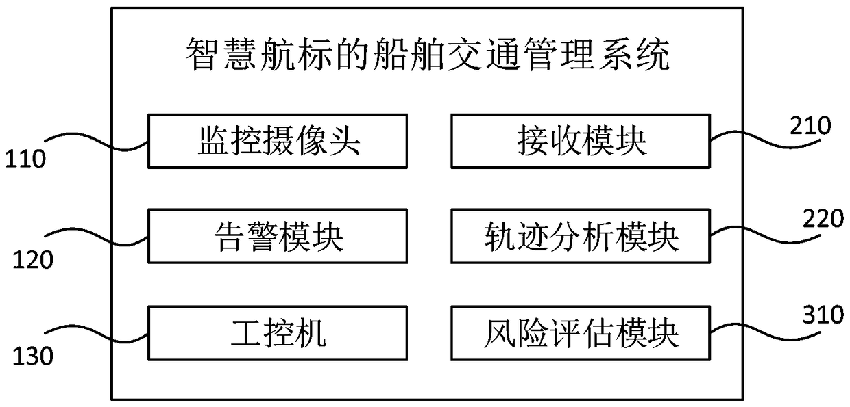
[0065] It should be noted that this step and step S10 are not necessarily performed sequentially, but can also coexist, that is, while collecting real-time images of the surrounding environment of the smart navigation mark through the camera, there are also corresponding devices on standby to receive and obtain the traffic microenvironment Ship information sent by ships in the past, but the camera collects real-time images of the surrounding environment of the smart navigation mark is always in progress, and the latter requires the passing ships in the surrounding environment of the smart navigation mark to send ship information first to trigger the receiving device to start receiving and obtain . In one specific implementation mode, the receiving device is selected to only receive ship information sent by passing ships in the surrounding environment of the smart navigation mark, that is, to limit the receiving distance of the receiving device; in another specific implementatio...

Embodiment 2

[0075] In the step S10 of this embodiment, the voice warning signal of "warning against reefs" is sent out through the VHF radio; in the step S20, the voice warning signal of "warning against ships collision" is sent out through the VHF radio. It is preferable to use the 16 channel of the VHF transmitter with a power of 1W to send the above two kinds of voice warning signals, which can make the communication distance about 3km, which is beneficial to transmit the warning signals to ships with high correlation, and make it easier to receive warnings The driver of the signaled ship is more vigilant, reducing the number of junk messages received by irrelevant ships, which is conducive to the drivers of unrelated ships to concentrate on driving safely.

[0076] In the step S10, an audible and visual warning signal of "warning against reefs" is also issued through the siren and the beacon light; in the step S20, an audible and visual warning signal of "warning of ship collision" is ...


PUM


Abstract

The invention relates to a smart navigation mark, and discloses a ship traffic management method and system for a smart navigation mark. The method comprises the following steps of: S10: collecting real-time images of the surrounding environment of the smart navigation mark; capturing the moving target in the real-time picture; judging whether the moving target enters the preset electronic fence area; if entering, issuing a warning message of ''crash warning''; S20: acquiring ship information sent by a passing ship in a surrounding environment of the smart warning, wherein the ship informationincluding the real-time position information of the ship; obtaining the trajectory of the ship based on the ship information and predict its future trajectory; calculating the probability of collision between the two ships according to the ship's future trajectory and the preset traffic conflict calculation model; issuing a "crash warning" warning sign if the probability exceeds a preset threshold. The Ship traffic management method and system for smart navigation mark can sense the water traffic behavior, the traffic risk assessment and alerting are well targeted, which can improve the traffic risk assessment and the alarm accuracy rate, and improve the warning communication effect.

Description

technical field [0001] The invention relates to a smart navigation mark, in particular to a ship traffic management method and system for a smart navigation mark. Background technique [0002] The buoy is an important water traffic facility for identifying reefs, indicating waterways, and guiding navigation. At present, the traditional buoy only has the function of light indication, which cannot meet the management needs of modern water traffic. Therefore, it is necessary to develop a water traffic behavior perception ability and risk notification. Smart navigation mark. [0003] Since the buoys are installed on inland rivers and seas, they cannot be powered by the existing power grid. Most of them use solar energy or tidal energy. Therefore, the energy supply is limited, and it is impossible to use power-consuming sensing and communication technologies on the buoys. For example, the most mature active sensing technology-radar technology, due to the limited radar beam width...

Claims


Application Information

Patent Timeline
Patent Type & Authority Applications(China)
IPC IPC(8): G08G3/02
CPCG08G3/02
Inventor 李登峰费巍
Owner FUZHOU UNIV
Why Eureka
Try Eureka