Satellite video small target real-time tracking method combining space confidence diagram and trajectory estimation

A real-time tracking and confidence map technology, which is applied in the field of satellite video tracking, can solve the problems of low target resolution and inability to track targets, and achieve the effects of real-time tracking, feasibility and effectiveness

Active Publication Date: 2019-03-08
WUHAN UNIV
View PDF4 Cites 8 Cited by
  • Summary
  • Abstract
  • Description
  • Claims
  • Application Information

AI Technical Summary

Problems solved by technology

Compared with the whole image, it occupies too few pixels. At the same time, most of the targets are similar to the background, and the resolution of the target itself is low. These problems have caused most mainstream tracking algorithms to be unable to continuously and effectively track the target track

Method used


Image

  • Satellite video small target real-time tracking method combining space confidence diagram and trajectory estimation
  • Satellite video small target real-time tracking method combining space confidence diagram and trajectory estimation
  • Satellite video small target real-time tracking method combining space confidence diagram and trajectory estimation

Examples


Embodiment Construction

[0043] The technical solutions of the present invention will be described in detail below in conjunction with the accompanying drawings and embodiments.

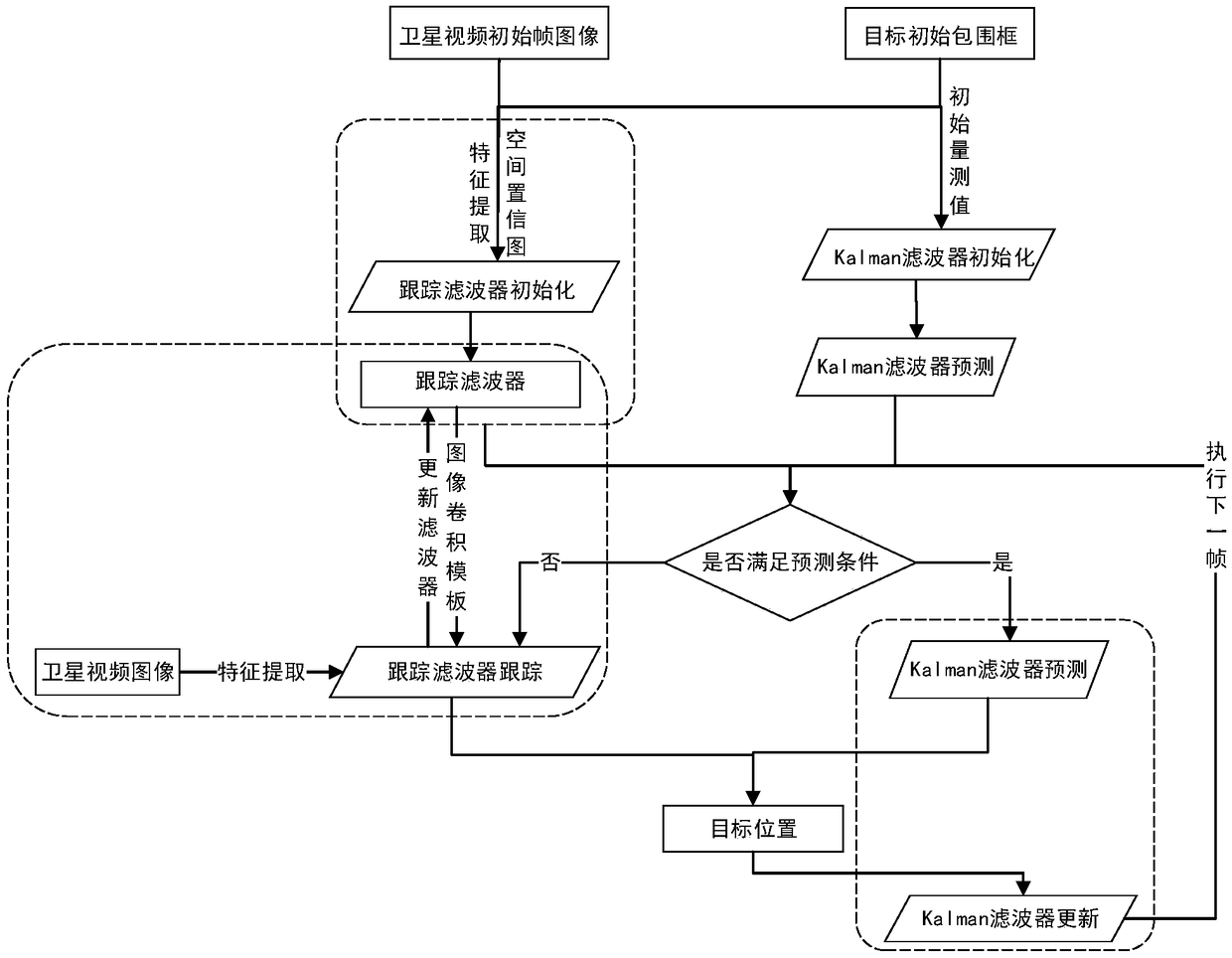
[0044] This method fully considers the characteristics of less pixels occupied by the target and high similarity with the background, and adds a spatial confidence map when training the classifier, eliminating the interference of similar targets or backgrounds in the adjacent area. At the same time, the almost invariant target scale in satellite video is used to reduce the training of multi-scale templates of the classifier, which greatly improves the tracking performance. Aiming at the problem that the target cannot be tracked when it is integrated with the background, the Kalman filter is trained to realize the trajectory estimation of the target, which ensures the continuous and effective tracking of the target.

[0045]Firstly, the tracking filter and the Kalman filter are initialized, which mainly includes extracting th...


PUM


Abstract

The invention discloses a satellite video small target real-time tracking method combining a space confidence diagram and the trajectory estimation, comprising the initialization of a tracking filterand the initialization of parameters of a Kalman filter. The tracking target position is utilized to regress a Kalman filter to predict a new position of the target. Fourier transform is used to extract features from the next frame image, and the maximum response value of the result is obtained through image convolution by using the constructed tracking filter, which is used as the new position ofthe target, and the feature update tracking filter is extracted with the new position as the center. A loop is executed to transmit that next frame image, whether the set prediction condition is metor not is judged, and the corresponding processing is carried out to extract a new position. This method not only guarantees the effectiveness of the tracking results but also has real-time tracking speed, taking into account the characteristics of less pixels relative to the background, no obvious shape features and high similarity between color and background in satellite video.

Description

technical field [0001] The invention relates to the technical field of satellite video tracking, in particular to a satellite video small target real-time tracking method combined with a space confidence map and trajectory estimation. Background technique [0002] Video satellite is a new type of earth observation satellite that has appeared in recent years. Compared with traditional satellites, it can continuously observe a certain area and generate dynamic video information with high temporal and high spatial resolution. At present, the NASA International Space Station has released satellite videos with a resolution of 1m, and the Jilin-1 commercial satellite launched by China can shoot satellite videos with a resolution of 0.72m. Compared with terrestrial video, moving targets in satellite video are not easily occluded and have a wide range of visibility, which makes high-resolution satellite video analysis have great potential in motion analysis, traffic monitoring, and ...

Claims


Application Information

Patent Timeline
Patent Type & Authority Applications(China)
IPC IPC(8): G06T7/246G06T7/262G06T7/277
CPCG06T7/246G06T7/262G06T7/277
Inventor 眭海刚陈旭孙向东付宏博杨威
Owner WUHAN UNIV
Why Eureka
Try Eureka