SLAM-based plane polygon object measurement method and machine-readable storage medium

A measurement method and polygon technology, applied in the field of photogrammetry, can solve the problems of complex quadrilateral vertex process, high requirements for use environment, unfavorable real-time measurement, etc., to achieve a good AR experience, meet detection requirements, and improve the effect of robustness

Active Publication Date: 2019-03-08
NANJING HUAJIE IMI TECH CO LTD
View PDF9 Cites 11 Cited by
  • Summary
  • Abstract
  • Description
  • Claims
  • Application Information

AI Technical Summary

Problems solved by technology

This measurement method has the following disadvantages: on the one hand, the process of detecting quadrilateral vertices in this patent is complicated, which is not conducive to real-time measurement; The actual measured value of the object takes a long time, has large errors, and has high requirements for the use environment, so the use area is narrow

Method used


Image

  • SLAM-based plane polygon object measurement method and machine-readable storage medium
  • SLAM-based plane polygon object measurement method and machine-readable storage medium
  • SLAM-based plane polygon object measurement method and machine-readable storage medium

Examples


Embodiment 1

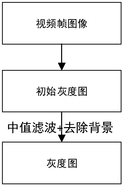
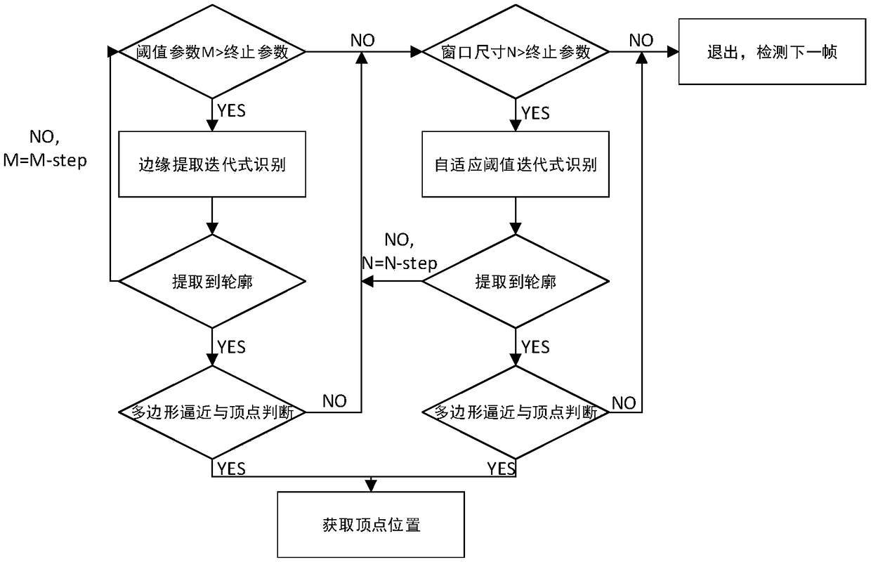
[0056] A SLAM-based planar polygonal object measurement method, V-SLAM calculates the orientation of the camera in an unknown environment through the captured video information, and constructs an environmental map at the same time. In real-time video information, if you want to measure a plane polygonal object, you must first identify it and extract the vertex position information of the polygon, which specifically includes the following steps:

[0057] In the initialization of this embodiment, first set the number of vertices or the range of the number of vertices of the polygon to be detected. The range of the number of vertices set in this embodiment is 3-6, which can meet most of the measurement needs in life , and by limiting the range, it is possible to filter out the situation that there are too many inaccurate vertices in the contour extraction after the next contour extraction; if there is only a detection requirement for a certain polygon (such as a triangle or a quad...

Embodiment 2

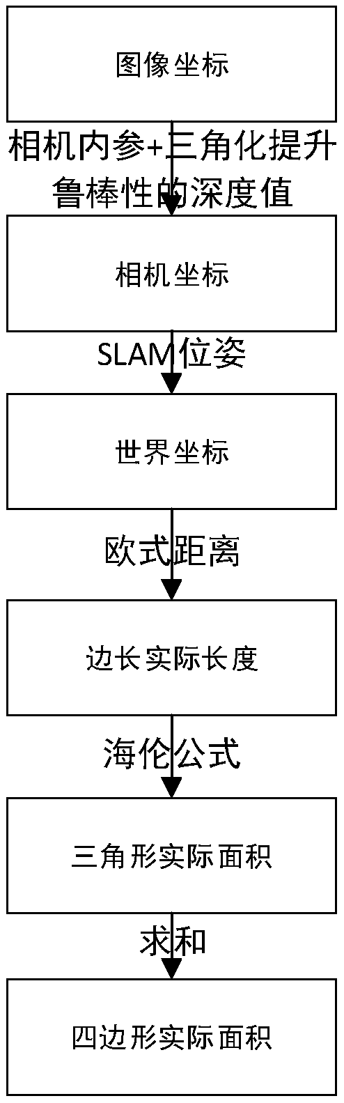
[0101] This embodiment is basically the same as Embodiment 1, except that in step (5), the forwarding method of transforming the coordinates of each vertex in the image coordinate system into the coordinates in the camera coordinate system adopts a triangulation method.

[0102] In this embodiment, when the depth information is unknown, for example, the depth camera is not used from the beginning of step (1) or the depth camera is used, but the depth information provided by the depth camera has obvious errors or the shooting object exceeds the range of depth information that the depth camera can recognize When , step (5) enhances the robustness of depth information through triangulation.

[0103] In addition, when a machine first uses a depth camera for measurement or a suspected depth camera failure, the triangulation calculation method can also be used to calculate the depth information of the vertices and compare it with the depth information provided by the depth camera to ...


PUM


Abstract

The invention discloses a plane polygon object measuring method based on SLAM and a machine-readable storage medium. By utilizing the posture information and depth information provided by SLAM, the vertices are mapped into the world coordinate system with the contour information of the video frame image, thus, the length and the area of the plane polygon object are calculated, the on-line real-time measurement is realized, and the method is more suitable for the mobile terminal, and can be used in augmented reality and virtual modeling of the mobile terminal, and can bring better AR experiencefor users, and is more convenient for people to demand for measurement in daily life. Moreover, the triangulation method can be used to improve the robustness of depth information, and two contour extraction methods and iterative method can be used to obtain a wider range of applications, which can meet the needs of image detection in different lighting scenes, and the measurement accuracy is high, and the measurement results are accurate.

Description

technical field [0001] The invention relates to photogrammetry, in particular to a SLAM-based plane polygonal object measurement method and a machine-readable storage medium. Background technique [0002] SLAM (simultaneous localization and mapping, simultaneous positioning and map construction) originated in the field of robotics. Its goal is to reconstruct the three-dimensional structure of the environment in real time in an unknown environment and simultaneously position the robot itself. SFM (Structure from Motion) technology generates 3D point clouds and camera poses from images. In the early days, it was generally processed offline. Later, with the development of technology, real-time SFM technology appeared, which can be attributed to the scope of SLAM. V-SLAM technology infers the orientation of the camera in an unknown environment based on the captured video information, and builds an environmental map at the same time. Its basic principle is the principle of multi-...

Claims


Application Information

Patent Timeline
Patent Type & Authority Applications(China)
IPC IPC(8): G06T7/62G06T7/64G06T7/13G06T7/136G06T5/30G06T5/00
CPCG06T5/002G06T5/30G06T2207/20032G06T2207/20036G06T7/13G06T7/136G06T7/62G06T7/64
Inventor 耿志远黄骏周晓军杜逢博李骊王行盛赞李朔杨淼
Owner NANJING HUAJIE IMI TECH CO LTD
Why Eureka
Try Eureka