A precise positioning and street view database acquisition method based on terminal shooting image matching

A technology for precise positioning and image capture, applied in the field of outdoor street view collection, pedestrian navigation and positioning, image processing and precise positioning, and can solve the problems of untimely update, high collection cost, and small coverage of panoramic map libraries.

Active Publication Date: 2020-10-20
NANJING UNIV OF AERONAUTICS & ASTRONAUTICS
View PDF5 Cites 0 Cited by
  • Summary
  • Abstract
  • Description
  • Claims
  • Application Information

AI Technical Summary

Problems solved by technology

[0005] Purpose of the invention: The purpose of the present invention is to propose a street view database acquisition and precise positioning method based on terminal shooting image matching, which can make up for the problems of small coverage, untimely update and high acquisition cost of the panoramic map library of the current map APP

Method used


Image

  • A precise positioning and street view database acquisition method based on terminal shooting image matching
  • A precise positioning and street view database acquisition method based on terminal shooting image matching
  • A precise positioning and street view database acquisition method based on terminal shooting image matching

Examples


Embodiment Construction

[0032] The present invention will be further explained below in conjunction with the accompanying drawings.

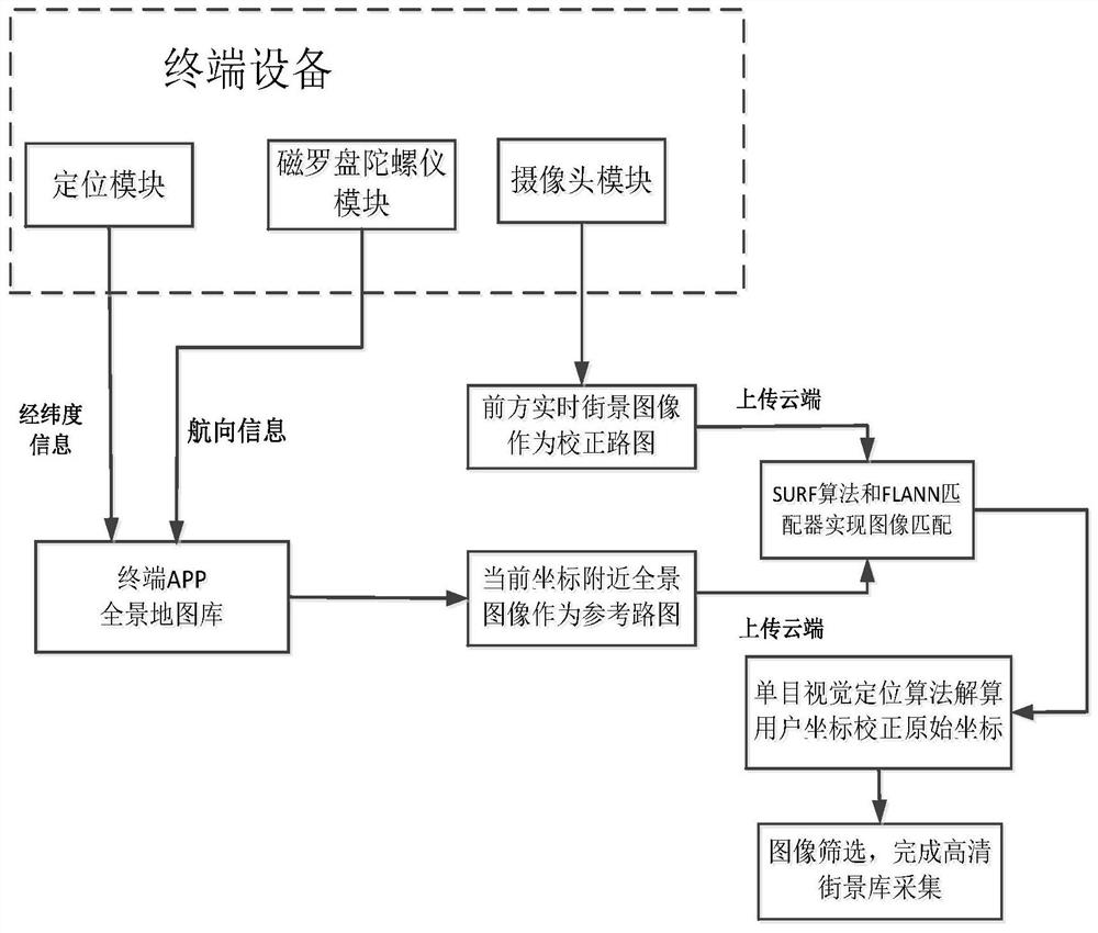
[0033] The present invention uses mobile phones, navigators and other terminals with high domestic penetration rate as the acquisition equipment of the high-definition street view database. Compared with the panorama map library that requires multiple vehicles and multiple digital cameras to collect, it can improve the collection efficiency and efficiency of the database. acquisition cost.

[0034] Since the present invention uses the visual positioning technology based on image feature point extraction and matching, the panoramic map library is used as the basic positioning library, and the data contained in the current panoramic map library is limited to the main roads, so the present invention is only applicable to outdoor positioning and navigation.

[0035] Panoramic map, also known as panorama map, refers to a map that simulates a three-dimensional picture into ...


PUM


Abstract

The invention provides an accurate positioning and streetscape library collecting method based on terminal shot image matching. The method comprises the following steps: acquiring a panoramic image near the current coordinates of a user through map APP of mobile phone, navigator and other terminal equipment to serve as a reference path graph, and acquiring a front high-definition real-time streetscape by utilizing a terminal camera module to serve as a correction path graph; calculating the user actual coordinates by adopting a feature point extraction matching and monocular distance measurement algorithm, and correcting the original coordinates; and adding longitude and latitude labels into the corrected correction path graph, and entering the streetscape library. The accurate positioningand streetscape library collecting method applied to the Internet time based on the increasing position service requirement can solve the problems of small panoramic map library coverage, untimely updating and high collection cost. Furthermore, optional points are increased, and image definition can be optimized when a user is positioned, visual positioning accuracy can be greatly promoted.

Description

technical field [0001] The invention relates to the fields of image processing and precise positioning, in particular to the technical fields of outdoor street scene collection and pedestrian navigation and positioning. Background technique [0002] In recent years, the development of map apps has brought a lot of convenience to pedestrians and vehicles. Map developers have also proposed panoramic map technology that can reflect the real environment of the destination. However, the collection of panoramic maps requires professional image equipment, which consumes a lot of manpower and material resources. At the same time, the panoramic images mainly cover the main roads, and most of the shooting time was one year ago, resulting in the problems of insufficient environmental data coverage and untimely update, which brings inconvenience to pedestrians and vehicles. [0003] At present, the methods applied to pedestrian and vehicle positioning include: GPS positioning, base sta...

Claims


Application Information

Patent Timeline
Patent Type & Authority Patents(China)
IPC IPC(8): G01C21/20
CPCG01C21/20
Inventor 胡强屈蔷
Owner NANJING UNIV OF AERONAUTICS & ASTRONAUTICS
Why Eureka
Try Eureka