Aerial hyperspectral multi-flight-strip image radiation distortion correction method

A distortion correction and radiometric correction technology, applied in optical radiometry, spectrometry/spectrophotometry/monochromator, spectrum survey, etc., to achieve seamless mosaic and improve radiation quality.

Inactive Publication Date: 2019-04-02
中国自然资源航空物探遥感中心
View PDF4 Cites 2 Cited by
  • Summary
  • Abstract
  • Description
  • Claims
  • Application Information

AI Technical Summary

Problems solved by technology

[0003] The purpose of the present invention is to provide a radiation distortion correction method for

Method used


Image

  • Aerial hyperspectral multi-flight-strip image radiation distortion correction method
  • Aerial hyperspectral multi-flight-strip image radiation distortion correction method
  • Aerial hyperspectral multi-flight-strip image radiation distortion correction method

Examples


specific Embodiment

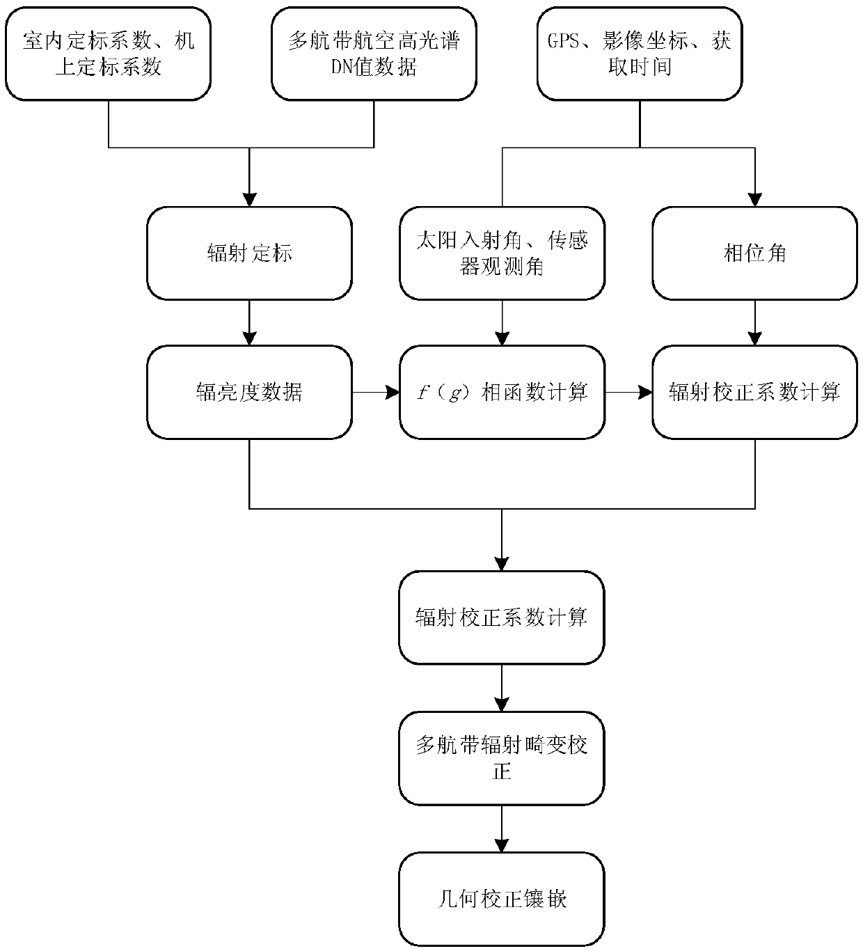
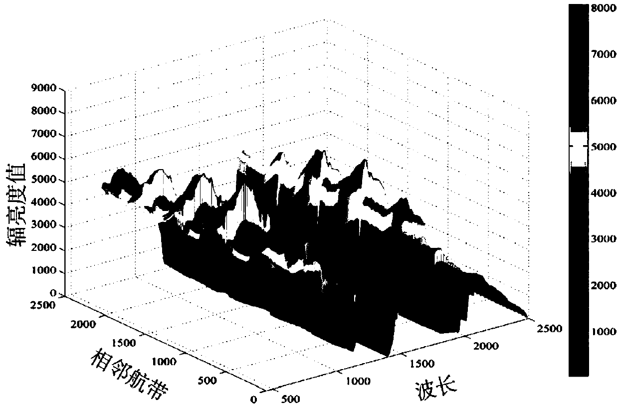
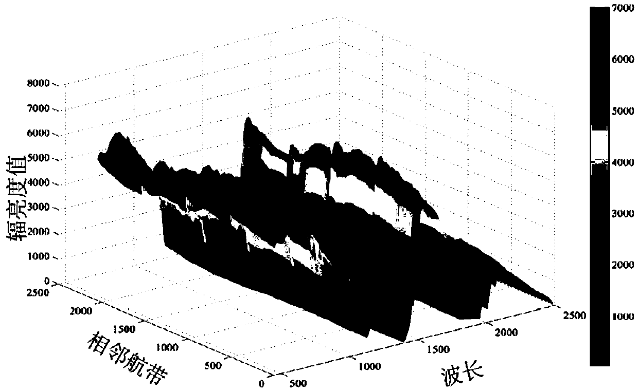
[0077] In this specific embodiment, a radiation distortion correction experiment is performed using HyMap airborne hyperspectral data. The data are hyperspectral data obtained in October 2002 from the China Land and Resources Airborne Geophysical Prospecting and Remote Sensing Center in the Huangshan-Huangshan East area of ​​Xinjiang. The experimental data consists of basic information such as the original DN value, sensor POS data, and flight altitude, and contains a total of 8 flight zones.

[0078] According to the method provided by the present invention, at first utilize on-board calibration coefficient and laboratory calibration coefficient to carry out radiometric calibration to above-mentioned hyperspectral data, convert DN value data into radiance value data; Utilize the GPS file of sensor track, image coordinate , obtain time and other information to calculate the sun incident angle, sensor observation angle and phase angle; put the calculated angle parameters and ra...


PUM


Abstract

The invention discloses an aerial hyperspectral multi-flight-strip image radiation distortion correction method and relates to the technical field of hyperspectral data radiation correction and application. The method is used for correcting a radiation distortion phenomenon generated between multi-flight-strip images caused by factors such as observation angles and light conditions; on the basis of traditional radiation correction, not only the radiation distortion caused by a sensor is corrected, but also a conversion coefficient of the radiation correction under a specific observation condition is obtained through the relation between a phase angle and a radiance value; according to the conversion coefficient, the radiation distortion data caused by the influence of the observation angle, the atmosphere and the illumination condition are corrected, thereby effectively improving the radiation quality of the aerial hyperspectral data. In addition, the method in the invention can carryout radiation distortion correction on the multi-flight-strip aviation data, thereby realizing seamless mosaic of large-area images and providing high-precision data for later quantitative application.

Description

technical field [0001] The invention relates to the technical field of hyperspectral data radiation correction and application, in particular to a radiation distortion correction method for aerial hyperspectral multi-airline images. Background technique [0002] With the continuous advancement of remote sensing technology, remote sensing data sources are gradually developing in the direction of high spatial resolution, high spectral resolution, and high temporal resolution. Since the 1980s, hyperspectral technology has gradually attracted the attention of more and more scholars. At present, quantitative remote sensing technology represented by aerial hyperspectral has been widely used in various fields and has become an important means of earth observation. However, due to the influence of sensors, atmospheric conditions, observation conditions and other factors in the process of aerial remote sensing data acquisition, the data often have large radiation distortion, which s...

Claims


Application Information

Patent Timeline
IPC IPC(8): G01J3/28
CPCG01J3/2823G01J2003/2826
Inventor 于峻川闫柏琨李逸川刘镕源贺鹏
Owner 中国自然资源航空物探遥感中心
Why Eureka
Try Eureka