Ecological environment remote sensing monitoring method

A technology for ecological environment and remote sensing monitoring, applied in measuring devices, radio wave measurement systems, radio wave reflection/re-radiation, etc., can solve problems such as low processing efficiency, inability to perform comprehensive dynamic monitoring, and low precision

Active Publication Date: 2019-04-05
BEIJING AEROSPACE TITAN TECH CO LTD
View PDF8 Cites 27 Cited by
  • Summary
  • Abstract
  • Description
  • Claims
  • Application Information

AI Technical Summary

Problems solved by technology

[0005] The purpose of the present invention is to overcome the above-mentioned technical defects, and provide a method for comprehensively utilizing heat, humidity, dryness, temperature, and water quality remote sensing to monitor the ecological environment, which can solve the problems of low processing efficiency and low precision in the existing ecological environment monitoring methods and problems that cannot be dynamically monitored in all directions

Method used


Image

  • Ecological environment remote sensing monitoring method
  • Ecological environment remote sensing monitoring method
  • Ecological environment remote sensing monitoring method

Examples


Embodiment 1

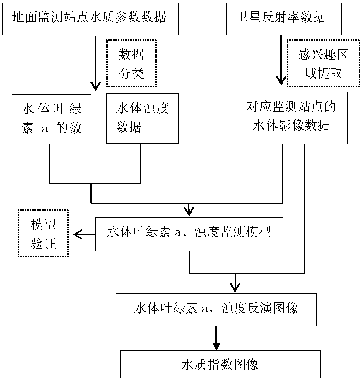
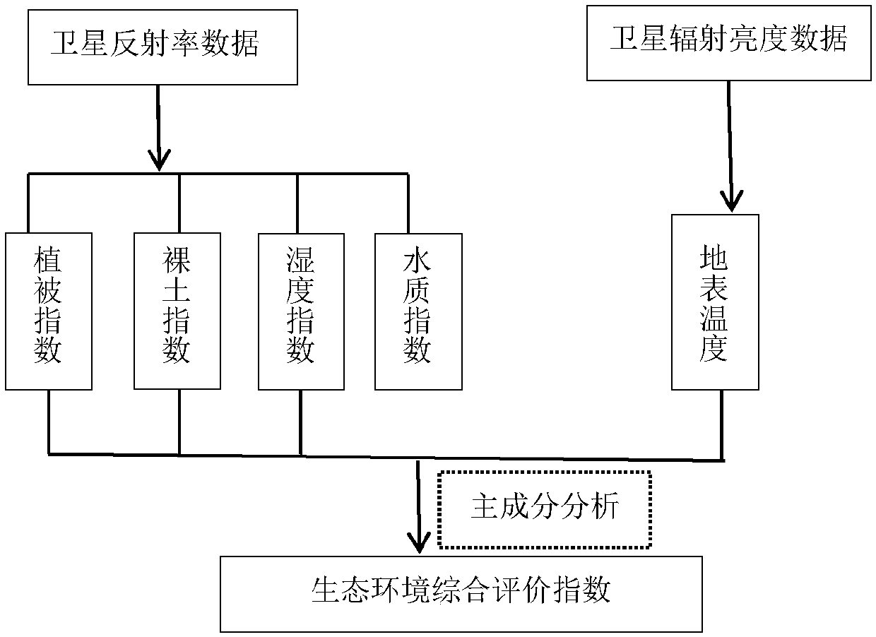
[0102] If the ecological environment monitoring area includes water bodies, such as figure 1 As mentioned above, Embodiment 1 of the present invention provides a method for remote sensing monitoring of the ecological environment, mainly including remote sensing monitoring of water quality environment, remote sensing monitoring of vegetation coverage, and comprehensive utilization of five indicators of water quality index, greenness, humidity, heat, and dryness. Ecological environment remote sensing monitoring method.

[0103] Receive water quality parameter data and corresponding remote sensing data in the monitoring area, the data at least include: chlorophyll a concentration, turbidity and corresponding satellite data and attribute data.

[0104] The attribute data table of the satellite remote sensor includes: the name of the satellite remote sensor for ecological environment monitoring and its corresponding working gain state, band number, start wavelength, stop wavelength...

Embodiment 2

[0177] Such as figure 2As shown, embodiment 2 of the present invention provides a kind of ecological environment remote sensing monitoring system, and described system comprises:

[0178] Satellite remote sensing data acquisition module: used to receive satellite remote sensing data covering the monitoring area, including high resolution GF1, GF2 satellite data, medium resolution Landsat8 satellite remote sensing data and other commonly used satellite data, and classify and manage satellite remote sensing data. Satellite data management mainly relies on the attributes of satellite data, including time query, sensor query, and range query.

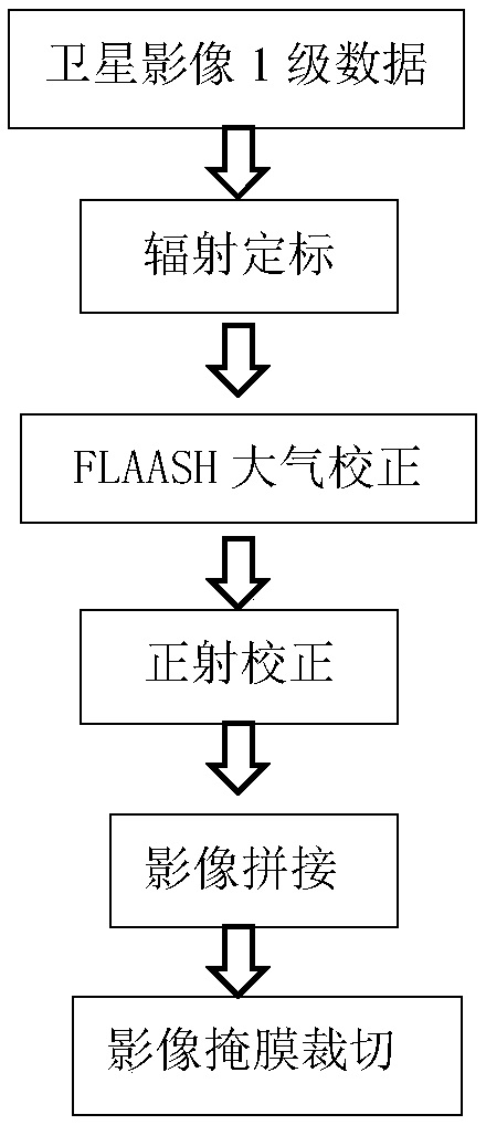
[0179] Satellite remote sensing data preprocessing module: preprocessing satellite data by means of geometric correction, radiometric correction, atmospheric correction, image fusion, image mosaic, image cropping, projection conversion, raster calculation, interpolation processing, data extraction, data conversion, etc. , and put the prep...

Embodiment 3

[0192] Embodiment 3 of the present invention provides the ecological environment remote sensing monitoring method that the monitoring area is the area not containing water body, and described method comprises:

[0193] Step 1) ecological environment remote sensing data processing; the specific processing process is the same as that of Embodiment 1.

[0194] Step 2) Establishing a vegetation coverage model: the normalized difference vegetation index (NDVI) is one of the important parameters reflecting the vegetation index growth and nutritional information. According to this parameter, the vegetation coverage of the ecological monitoring area can be known. The NDVI images were constructed by using the reflectance images of the red channel and the near-infrared channel of the Landsat8 image, and the monthly multi-view NDVI images of the ecological monitoring area were synthesized by using the maximum synthesis method.

[0195] NDVI=(R nir -R red ) / (R nir +R red )

[0196] ...


PUM


Abstract

The invention provides an ecological environment remote sensing monitoring method. The method is used for monitoring ecological environment of a monitor area comprising a water body. The method comprises steps of S1, receiving and processing remote sensing image data of the ecological environment monitor area, and acquiring processed remote sensing data; S2, creating a water quality parameter inverse model, and inputting remote sensing data of step S1 into the model, and calculating water quality index of the monitor area; S3, calculating four remote sensing characteristic parameters of the monitor area: vegetation index, bare earth index, humidity index and ground temperature; and S4, creating an ecological environment comprehensive evaluation model of a water containing body by using a main component analysis method, and inputting five remote sensing characteristic parameters of steps S2 and S3 into the ecological environment comprehensive evaluation model of the water containing body, so as to monitor the ecological environment of the monitor area. In the method, the ecological environment is monitored by using remote sensing images, so that human intervention is prevented, andthe ecological environment is monitored more effectively and accurately.

Description

technical field [0001] The invention relates to the field of ecological environment remote sensing, in particular to an ecological environment remote sensing monitoring method. Background technique [0002] Population growth and the improvement of industrialization level have intensified the contradictions among population, resources, and environment, and ecological environmental problems such as water pollution and desertification are constantly emerging. Accurate evaluation of the ecological environment is conducive to the protection of the ecological environment. [0003] With the continuous development of remote sensing technology, the relevant models of ecological environment monitoring are constantly improving, and the application of remote sensing monitoring technology in the monitoring of ecological environment is becoming more and more common. The existing ecological environment monitoring method mainly adopts the distributed monitoring method of ground monitoring s...

Claims


Application Information

Patent Timeline
Patent Type & Authority Applications(China)
IPC IPC(8): G01S13/89
CPCG01S13/89
Inventor 刘勇姜航徐劲学李磊
Owner BEIJING AEROSPACE TITAN TECH CO LTD
Why Eureka
Try Eureka