Automatic city function partitioning method and system based on streetscape data and transfer learning

An urban function and transfer learning technology, applied in the computer field, can solve the problems of large segmentation scale, strong subjectivity, coarse classification granularity, etc., and achieve the effect of reducing geographic location errors, improving training convergence speed, and accurate classification.

Inactive Publication Date: 2019-04-19
CHINA UNIV OF GEOSCIENCES (WUHAN)
View PDF5 Cites 13 Cited by
  • Summary
  • Abstract
  • Description
  • Claims
  • Application Information

AI Technical Summary

Problems solved by technology

However, the traditional division of urban functional areas is mainly based on field surveys or methods assisted by remote sensing technology or based on social media data. These methods have some limitations:
[0003] (1) Based on the field survey method, there are problems such as strong subjectivity, poor timeliness, and need to consume a lot of manpower and financial resources.
[0004] (2) The method assisted by remote sensing technology usually only obtains the attribute values ​​of the

Method used


Image

  • Automatic city function partitioning method and system based on streetscape data and transfer learning
  • Automatic city function partitioning method and system based on streetscape data and transfer learning
  • Automatic city function partitioning method and system based on streetscape data and transfer learning

Examples


Embodiment Construction

[0046] In order to have a clearer understanding of the technical features and purposes of the present invention, the specific implementation manners of the present invention will now be described in detail with reference to the accompanying drawings.

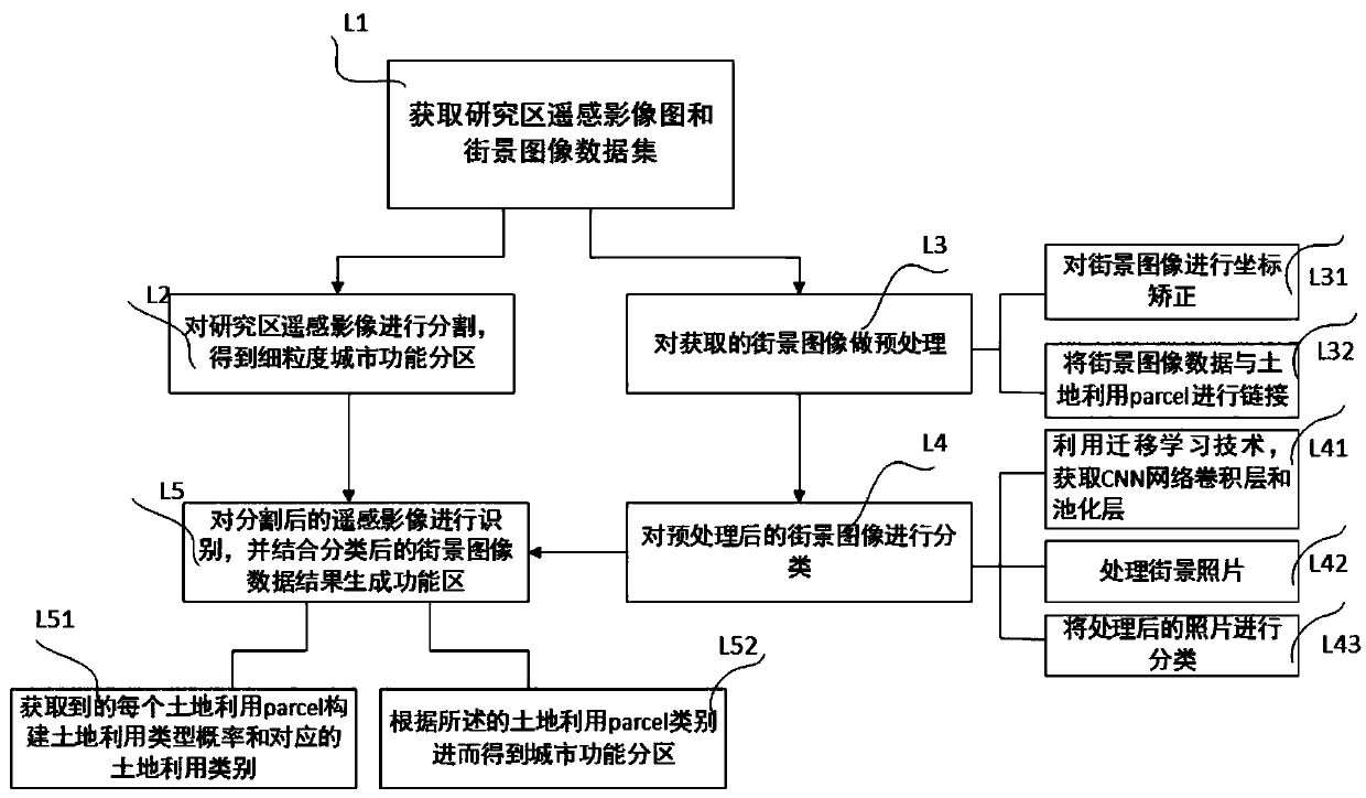
[0047] Please refer to figure 1 , which is a flow chart of a method for urban functional zoning, specifically including the following steps:

[0048] L1. Obtain the remote sensing images and street view photos of the research area from the map website, for example, obtain the remote sensing image maps of the research area from the Google Maps website; download the street view photo data from the street view photo API interface provided by Tencent Maps, and unify the obtained street view photos Name it and adjust it into a unified format, such as longitude_latitude_angle.png, and adjust the pixel size of the obtained street view photos to: 480*300; obtain the OSM land use vector data of the research area from the OpensStreetMap w...


PUM


Abstract

The invention provides an automatic city function partitioning method and system based on streetscape data and transfer learning. According to the method and the system, urban functional areas are automatically identified based on streetscape photos, a deep learning technology and an image segmentation technology, and an urban functional partition map is automatically obtained by using streetscapephoto scene semantic information in combination with classified urban area file data obtained by the image segmentation technology. The method can be used for automatically and accurately identifyingfine-grained urban functional areas, and brings opportunities to urban planning and urban environment development.

Description

technical field [0001] The invention relates to the field of computers, in particular to a method and system for automatic urban function zoning based on street view data and transfer learning. Background technique [0002] Urban functional zoning is an important basis for a series of applications such as urban planning, environmental research, and spatial planning. The rational division of urban functional areas helps to rationally plan and grasp the urban spatial structure, and formulate scientific development plans for the city. However, the traditional division of urban functional areas is mainly based on field surveys or methods assisted by remote sensing technology or based on social media data. These methods have some limitations: [0003] (1) The method based on field investigation has problems such as strong subjectivity, poor timeliness, and requires a lot of manpower and financial resources. [0004] (2) The method assisted by remote sensing technology can usuall...

Claims


Application Information

Patent Timeline
IPC IPC(8): G06K9/00G06K9/62G06T7/11G06F16/29G06N3/04G06N3/08
CPCG06N3/08G06T7/11G06T2207/10032G06T2207/20081G06V20/13G06N3/045G06F18/24
Inventor 方芳余亚芳刘袁缘姚尧阚文泽周顺平
Owner CHINA UNIV OF GEOSCIENCES (WUHAN)
Why Eureka
Try Eureka