A real-time wind speed measurement system and measurement method for arrow-borne three-dimensional height

A real-time wind speed, measurement system technology, applied in fluid speed measurement, speed/acceleration/impact measurement, measurement device and other directions, can solve the problem that the measured data is not enough to meet the actual needs, the simultaneous measurement of wind speeds at different altitudes, and the accuracy of the measurement results. and other problems, to achieve the effect of improving flight safety and operation effect, avoiding inaccurate measurement and high work efficiency

Active Publication Date: 2021-07-23
SOUTH CHINA AGRI UNIV
View PDF6 Cites 0 Cited by
  • Summary
  • Abstract
  • Description
  • Claims
  • Application Information

AI Technical Summary

Problems solved by technology

Low-altitude aerial vehicles such as drones and airships have been widely used and popularized in the civilian field, especially the continuous promotion and application of agricultural plant protection drones. The meteorological conditions of the environment, especially the wind speed, have certain requirements, and the wind speed will also affect the effect of its work. Therefore, the detection of meteorological conditions such as wind speed in the three-dimensional height direction is particularly important; and the current ground meteorological observation stations can only detect The meteorological parameters at lower altitudes are limited by equipment, and the measured data are not enough to meet actual needs
At present, there are three-dimensional height wind speed detection using drones, but the wind field generated by the drone itself will affect the accuracy of the measurement results, and it is impossible to measure wind speeds at different heights at the same time; Tethered testing equipment such as auxiliary tools, but its device structure is complicated, there are many parts that need to be arranged, the measurement process is complicated, it is impossible to quickly obtain meteorological conditions such as wind speed, and the work efficiency is low

Method used


Image

  • A real-time wind speed measurement system and measurement method for arrow-borne three-dimensional height
  • A real-time wind speed measurement system and measurement method for arrow-borne three-dimensional height
  • A real-time wind speed measurement system and measurement method for arrow-borne three-dimensional height

Examples


Embodiment

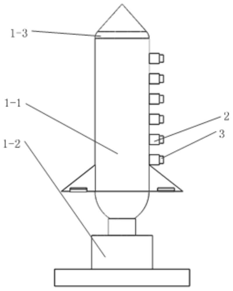
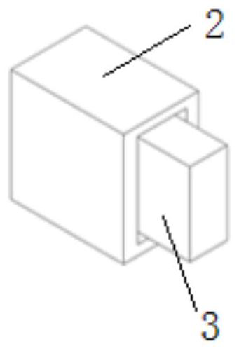
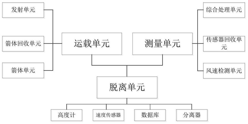
[0028] see figure 1 , 2 , the real-time wind speed measurement system for arrow-borne three-dimensional altitude provided in this embodiment includes a carrying unit 1 , a detachment unit 2 , and a measurement unit 3 . There are multiple detachment units and measurement units, and the measurement units are nested on the detachment unit; through multiple detachment units 2, multiple measurement units are fixed on one side of the carrying unit 3 in a vertical line.

[0029] The carrier unit 1 includes a rocket body unit 1-1, a launch unit 1-2, and a rocket body recovery unit 1-3, and the detachment unit is arranged on the rocket body unit. Wherein, the rocket body unit has a pair of empennages, and the ailerons are provided on the empennage, and the ailerons on the empennage are used to balance the arrangement of the measuring unit on the rocket body unit, and to solve the unbalanced problem of the rocket body unit caused by the separation of the measuring unit, Thereby, the r...


PUM


Abstract

The invention relates to near-earth meteorological detection technology, which is an arrow-borne three-dimensional height real-time wind speed measurement system and its measurement method, including a carrying unit, several detachment units, and several measurement units; the measurement units are nested on the detachment unit, and several measurement units pass through several The unit is fixed on one side of the carrying unit; after the carrying unit carries several measurement units to the corresponding separation height points, they are separated by the separation unit. After separation, each measurement unit moves vertically to the measurement height point to measure the instantaneous wind speed and measure the The measured instantaneous wind speed data is sent back and stored in real time. The invention uses the carrier unit to release the measurement unit, avoids measurement errors due to rapid changes in the three-dimensional wind speed, is conveniently applied to the measurement of the three-dimensional wind speed near the ground, reduces the loss of observation data and improves the accuracy of the measurement data, so that the measurement The data can provide timely guidance for UAV flight and aerial spraying operations.

Description

technical field [0001] The invention relates to near-earth meteorological detection technology, in particular to an arrow-borne three-dimensional height real-time wind speed measurement system and a measurement method thereof. Background technique [0002] With the advancement of science and technology and the development of the technological revolution in the aviation field, the field of aviation at near-Earth space heights has been widely used and valued. Low-altitude aerial vehicles such as drones and airships have been widely used and popularized in the civilian field, especially the continuous promotion and application of agricultural plant protection drones. The meteorological conditions of the environment, especially the wind speed, have certain requirements, and the wind speed will also affect the effect of its work. Therefore, the detection of meteorological conditions such as wind speed in the three-dimensional height direction is particularly important; and the cu...

Claims


Application Information

Patent Timeline
Patent Type & Authority Patents(China)
IPC IPC(8): B64G1/22B64G1/62G01P5/00
CPCB64G1/22B64G1/62G01P5/00
Inventor 李继宇展义龙李一凡郭爽
Owner SOUTH CHINA AGRI UNIV
Why Eureka
Try Eureka