
Hyperspectral remote sensing judgment method for degree of soil salinization

A technology of hyperspectral remote sensing and salinization, which is applied to the measurement of color/spectral characteristics and weighing by removing certain components, which can solve the problems of time-consuming and labor-intensive, inaccurate judgment methods, etc.

Active Publication Date: 2019-05-10
NORTHWEST A & F UNIV
View PDF5 Cites 8 Cited by
  • Summary
  • Abstract
  • Description
  • Claims
  • Application Information

AI Technical Summary

Problems solved by technology

[0005] In view of this, the embodiment of the present invention provides a hyperspectral remote sensing method for judging the degree of soil salinization, the main purpose of which is to solve the problems of inaccurate judgment, time-consuming and labor-intensive

Method used


Image

  • Hyperspectral remote sensing judgment method for degree of soil salinization
  • Hyperspectral remote sensing judgment method for degree of soil salinization
  • Hyperspectral remote sensing judgment method for degree of soil salinization

Examples


Embodiment 1

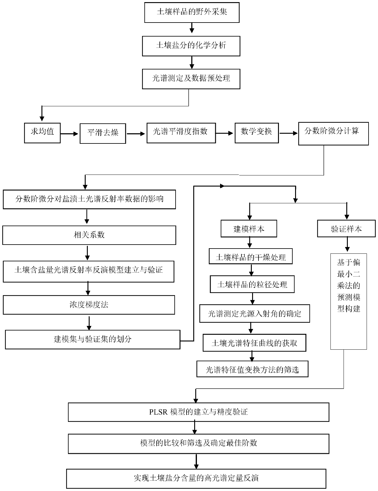
[0061] Step 1: Use a ring knife with a depth and diameter of 5.5 cm and a diameter of 7.5 cm to collect the soil below 5 cm on the soil surface to obtain undisturbed soil samples, and remove the immersed body during collection;

[0062] Step 2: Put the ring knife into a plastic box to seal, number, weigh and bring it back to the laboratory; take a representative soil sample of about 20g from the ring knife and put it into the aluminum box, cover it and weigh it, and record the aluminum The number and weight of the box, put the uncovered aluminum box into the drying box, and measure the moisture content of the soil sample by the drying method under the constant temperature of 105 ° C and 24 h. m , ω m The formula is:

[0063]

[0064] In the formula, M 1 It is the quality of the undisturbed soil sample (including aluminum box); M 2 It is the quality of the undisturbed soil sample (including aluminum box) after drying; M 3 For the quality of the empty aluminum box;

[00...


PUM


Abstract

The invention discloses a hyperspectral remote sensing judgment method for degree of soil salinization, and relates to the technical field of geography. The method provided by the invention comprisesthe following steps: collecting the undisturbed soil samples below the surface layer of the soil as original soil samples; measuring the original soil samples and the weight after drying, calculatingthe moisture content of the soil samples; measuring the spectral reflectance of the original soil samples to obtain an original spectral reflectance; performing SG smooth denoising on the original spectral reflectance; sorting the original soil samples from high to low according to the soil salt content, and dividing a modeling set and a sample set; preprocessing the hyperspectral data; performingfractional differential processing, establishing a soil salinity least squares regression model by using the processed data; comparing RMSEc, 2cR, RMSEp, R2p and RPD, and screening the best model tostudy the soil salt content inversion in the study area; inputting hyperspectral information of unknown soil samples through the optimal model to fast and accurately obtain the salt content of the soil sample, and comparing with the salinization classification standard table to accurately determine the degree of soil salinization.

Description

technical field [0001] The invention relates to the technical field of geography, in particular to a hyperspectral remote sensing judgment method for soil salinization degree. Background technique [0002] Soil salinization refers to the process in which the salt in the bottom soil or groundwater rises to the surface with capillary water, and after the water evaporates, the salt accumulates in the surface soil. It refers to the phenomenon or process in which soluble salt accumulates on the soil surface, also known as salinization. China's saline soil or saline-alkali soil has a wide distribution, large area and many types, with a total area of ​​about 100 million hm2. Mainly occurs in arid, semi-arid and sub-humid areas. Soluble salts of saline-alkaline earth mainly include sulfates, chlorides, carbonates and bicarbonates of sodium, potassium, calcium, and magnesium. Sulfates and chlorides are generally neutral salts, and carbonates and bicarbonates are basic salts. The ...

Claims


Application Information

Patent Timeline
IPC IPC(8): G01N21/31G01N5/04
Inventor 张智韬劳聪聪王海峰
Owner NORTHWEST A & F UNIV
Learn More